Like any good moosefish story we'll start with the references to past stories. Way, way back in time (July 4, 2003 in fact) Tokul and I blitzed up Mt. Catherine before the fireworks started. In the summer you approach from near Windy Pass and it's a short, aggressive little hike. Just right for a summer morning rumble.
Fast forward to last week and a TNAB Lunatic trip on the Nordic Pass trail. We managed to only make it to Rockdale Lake, but now I knew where this great little trail started and the secrets to getting at least to Hyak Lake.
Less than two weeks after the TNAB trip I listed an attempt up Mt. Catherine as a choice for Dan for what will probably be our only day-time snowshoe this season. (Dan's due to be a father of two just before the new year.) Time was a constraint so a trip with only a half hour drive seemed a better choice than more distant destinations.
Unfortunately, we started the day in foul spirits. Neither of us had filled up with coffee courtesy of a little storm that knocked out power to about 1.5 million people in the region. However, we figured that maybe, just maybe there'd be some place with a Coleman stove selling espresso at the Pass. Turns out there were multiple coffee places. The first didn't take credit cards (isn't this 2006?) and the second had no milk courtesy of a little storm... blah blah blah. While I was considering the possibility of pounding a couple of shots over ice to stave off the inevitable headach the milk delivery came and we were saved. Thanks be to Red Mountain Coffee! (We weren't the only ones dying for coffee, either. A snowshoer headed for Hex Mountain (1 2 was fueling up, too.)
We parked in the Hyak lot next to another car in the corner of the lot nearest the trailhead. With a WTA sticker in the back window it was clear they were going where we were going. Sweet. Someone would be breaking trail for us! (One of the toughest parts of snowshoeing is stepping through fresh snow. It's beautiful, but dang hard.)
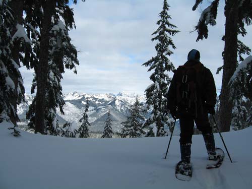
It was 15F, but no wind. The sun was peaking beneath the clouds as it rose in the east turning the eastern slopes of the mountains a brilliant orange.
We geared up, crossed the creek, and discovered we were following skiers. Dang. Etiquette demands we stay off their tracks so we were now breaking trail right next to an established trail. Ugh.
We made great time up toward Hyak Lake, the first landmark. In fact, we made better time than the skiers and caught them under the wood power lines. One of the skiers was Carla who I've hiked with on TNAB outings. She was even foolish enough to invite me on a snowshoe trip up Mt. Kent, but I had to bail. Next time, certainly.
We buzzed past Hyak Lake and crossed the road following blue diamonds with ease. Trying to follow the route in the dark was a bit challenging, but in daylight it was easy to see the diamonds... at least until we crossed the metal powerline corridor. After that it got kind of dicey. We followed a set of tracks down into the Mill Creek drainage, but they turned around. With much determination we started breaking trail back up the hill to where we though the route should be.
Amazingly, we actually found the diamonds again. (On the way back we could see where we had gotten off-route and I don't feel too bad about it.) No one had been this way since the last big snow so we hunted for diamonds on the trees and broke trail through the fresh snow. We passed right by Frog Lake (not much of a lake, actually) and continued up the gentle slope to Nordic Pass.
It had taken about two hours to get to Nordic Pass, but aside from fresh snow and some neat tree views there was little reward. The big payoff would come atop Mt. Catherine, which was still about 1,000 feet above us.
We abandonned the diamonds for a more direct route around the shoulder of Mt. Catherine and ran into some tracks that had come up from the Twin Lakes or Olallie Meadow side. No longer breaking trail, but gaining elevation, we made good time climbing. The first 500 feet of gain came quickly, but then we started a series of false summits.
Worse, the party we were following had turned around on the first falsie at about 4,500 feet. That meant we were back to breaking trail through now deeper snow on a steeper slope. We traded off the lead and plugged up the hill. The biggest gain was the second to last. It seemed terribly high, but probably wasn't. I had switched out one of my poles for my ice axe ('cuz it makes me look cool) so I was hampered in my climbing ability slowing us down.
When it leveled out we saw we were still about 200 feet shy of the summit. Onward and upward until we were at a narrow point on the ridge. The the north and south the slope dropped off steeply. Studying the avalanche forecast showed a "considerable" or "moderate" risk of avalanche in this area so I was unenthused at the prospect of crossing either slope. (Especially since I couldn't see the bottom of either.) Instead, I threaded the thick trees straight up the spine.
Unfortunately, a large rock outcropping blocked my way. Inching around it I rested against a big tree and looked up the last 15 feet to the clear sky above. The snow in front of me was very steep. Poking at it with my axe (see? it came in handy after all!) revealed that there was a couple of inches of windblown snow on top, a thin crusty layer, and powder underneath. The rock that this all sat on was coated in thick ice.
It was time to turn back.
Being so close to the summit means I probably won't try this again during the winter for a long time. There are too many other local peaks that call out for climbs.
We retreated to a relatively flat spot a couple hundred feet downhill and stopped for food. I had already eaten much of my lunch so I fumbled with an orange with freezing fingers. My water hose had frozen long before we were even out of the Pass area so I was short on water. After eating quickly we headed back down. We took advantage of the steep slopes to high-step through the powder turning our snowshoes almost into skis as we slid.
Right at Nordic Pass we ran into Carla and her party again. They had spent the day in Olallie Meadows climbin and skiing the powder there. After lamenting about our summit failure we parted and headed back. Just after we got under way we encountered our biggest challenge.
Although the skiers had made their own trail next to ours for much of the route they had commandeered our trail for parts. Were we supposed to stay off it now that skiers had used it or could we tromp it back down into a snowshoe trail like it was when we made it? I tried my best to stay off it, but the effort of breaking a second trail through the area was a bit much and I succumbed to taking back our trail.
Where the trails diverged we stuck to snowshoe tracks, but that wasn't too often. I figured that since they had skied on snowshoe tracks once it wouldn't be a big deal to do it again... right? This worked until we saw our tracks splitting off downhill while the ski tracks and the diamonds stayed higher on the ridge. Now we were back to breaking trail and taking care not to trod upon the trail they had made.
The rest of the trip out was uneventful. The track became a highway around the metal power lines and it was all downhill. In spite of the good weather we saw only the skiers all day long. If only we could have made that last few feet... <sigh>
Total distance was about eight miles and 2,600 feet of gain. It took about four hours going up and two coming down.