How I learned to look past the pain and enjoy the view
The rangers said the route was packed with snow. Ice-axes and cramp-ons would be needed over most of the passes. I'd need "bars" and water and food and clothes and batteries (and more batteries) and medical supplies and in the end I had 48 pounds in my pack.
Then we added the tent to distribute the load between the three of us. Figure about 55 to 60 pounds. Finally, we were good to go.
But go where?
Initially
we had planned to hike from Rainy Pass on the North Cascades Highway north into British Columbia. We even got permission from our neighbors to the north so we wouldn't be shot crossing the border, but talk of ice-bound passes scared us to a lower, southern route.
We'd start near Darrington at the Whitechuck Trailhead. Jenn was kind enough to drop us off after braving a nasty dirt road and a family of suicidal deer. After one last hug and kiss (well, Dan got that even if Nick and I didn't) and a farewell picture in front of the trail we disappeared into the woods.
I'd never done a major hike like this before and never even backpacked on an overnighter. My training was intense (no? you try carrying 60 pounds up McClellan Butte and tell me that's not intense), but always promised a soft bed at the end of the day. Needless to say, I was a tad nervous about the prospect of five days in the woods and how far behind the others I'd be when/if we finally exited at Stevens Pass some 60 miles to the south.
All that passed quickly, though, as we found a groove and motored up the Whitechuck River valley toward Kennedy Hot Springs. The route was largely uneventful and rather boring. We were under heavy canopy most of the day so in spite of a brilliant blue sky and about 70°F temperatures it was just a day of walking.
At the hot springs we spun around in circles for a while trying to determine which way to go before figuring it out and headed up a 700 foot hill on the last few miles to the PCT. It was on this hill that I pretty much expended most of my energy for the next couple of days. Poor planning, huh? On the upside, I was able to push up to the top in short order which gave me a great feeling of accomplishment.
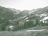
Once on the PCT itself we turned from east to south and made good time walking along the base of Glacier Peak. As we neared the end of the day we emerged from the forests and started looking for a campsite with water close by. We'd hiked about 15 miles by this point and we were all dragging just a bit. We found a good site with a flat area for the tent and a stream right near by, but at only 4,800 feet of elevation it seemed we might as well gain another 200 feet and spend all four nights above the 5,000 foot mark. Good idea, if I do say so myself.
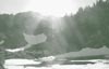
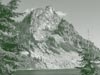
Of course, there was no good campsite at 5,000 feet. Nor at 5,100 feet. In fact, there weren't any good campsites for the next 400 feet so by the time we found something suitable at 5,413 feet and one and a half miles further along the trail we were completely hammered. On the upside, we had a stunning view of Glacier Peak only four miles away.
Glacier Peak is 10,541 feet tall, covered with glaciers (duh) and wasn't on our agenda this time around. Thankfully. It did make up for the couple of small blisters on my feet to see the sun turn the mountain red while a few small clouds floated by.
Oh yeah, we negotiated 40 switchbacks this first day.
Four passes
We
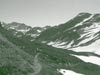
woke not particularly early and prepared ourselves to head back onto the trail to face four consecutive passes before ending near Lake Sally Ann about 13.5 miles to the south. First up was Red Pass, now known (to me) as "that place I thought I'd never get to the top of."
Dan and Nick both hike faster than I do. That's fine, because I can usually keep up, but Red Pass pretty much shut me down. I still don't know exactly what it was that hurt me so as we climbed the thousand or so feet over a couple of miles to the pass at 6,562 feet, but after many, many stops to catch my breath I finally stumbled to the top.
No sooner than I had arrived than Nick and Dan decided we should all climb to the peak that looked over the pass which was only another hundred or so feet, but almost straight up. I dropped my pack to be scavenged by wolves and crazy Texans and followed wearily with but a bar and a bag of coffee beans for nourishment.
Amazingly, just a wee bit of food was what I needed. I soon exited my bonked state and regained much of my composure. Heck, I even took a bunch of pictures (big surprise) as we watched other hikers move up the expansive valley like little ants.
From Red Pass we headed down the other side of the ridge along a drop of about 3,000 feet to the North Fork of the Sauk River. If uphill was a problem for me then downhill was even worse. The pounding on my knees wasn't actually as bad as I thought it would be so I allowed myself to look around at the scenery while rushing down the dusty path which was perhaps as wide as three feet in places. That was probably when I started falling.
No, I didn't fall 3,000 feet to the river, but I did take a wicked tumble. As I began falling forward and to my right (the side with the drop-off) I realized my impending doom and pushed out my right arm. I finally settled face down in the dust with a gash in my palm and a couple great raspberries on my elbow, but otherwise unharmed. Joy.
After that I resolved to be a lot more careful while heading downhill and make better use of my trekking poles. If you've never used trekking poles before let me tell you that they are a godsend. I wouldn't consider a hike of any length without them after the assitance they provided me on this trip. On the uphills I was able to shift a couple of pounds to my arms and give my legs a bit more distance and on the downhill I increased my stability and took some weight off my knees. Yeah, Nick and Dan were jealous, but there was no way I was giving them up. (BTW: Don't get trekking poles. Get snowshoe poles and mud baskets. Two seasons of use for an extra $4.)
We passed through White Pass, drank from Reflection Pond, skipped by the stagnant Kid's Pond, and found ourselves heading down into a valley with a brutal uphill on the other side. Where's Indian Pass? GPS says it's right here, but we're at the bottom of a valley. What's up?
Oh yeah, a pass is a saddle with two or more trails intersecting. Instead of climbing to it we descended into it. This type of pass is far from my favorite. Why? There's no view and immediately following it you get to go back up. Yummy.
From Indian Pass we climbed up to Dishpan Gap. (What's the difference between a "pass" and a "gap?" We think that a gap has no trail intersections, but we could be wrong.) From Dishpan Gap we cruised to Ward's Pass and finally made it to Lake Sally Ann. Once again I was at the end of my abilities as we climbed to the frozen basin at about 5,500 feet.
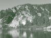
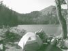
Lake Sally Ann was undeniably gorgeous. We camped on the edge of a cliff looking out to the valley formed by the stream draining the lake. A stiff breeze blew any bugs away from us as the setting sun disappeared over the mostly frozen lake.
I added six more blisters and we conquered 19 more switchbacks.
Rebounding
Day
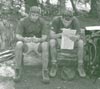
three was to be a shorter hike (otherwise we'd finish in four days instead of five) so we planned about 11 miles with Pear Lake as our destination. Sore, but eager to get moving and energized by a quality camp mocha (espresso (yes, Dan lugged his espresso machine out for me) and Hershey's syrup) we left at about our usual time of 9:30.
The day was characterized mostly by more of the same. The views weren't as rugged as we had seen by Glacier Peak and the hills were of the same caliber as the days before, but after a hard day of passes I suddenly was filled with energy.
The big marker for the day was my climb from Cady Pass (another of those crappy bottom-of-the-hill passes) at 4,000 feet to Saddle Gap at about 5,000 feet without stopping. Don't ask what got into my head for I really don't know. When we left Pack Creek at the bottom of the hill I began a slower-than-normal ascent with the idea that I wouldn't stop as frequently as I had on similar hills earlier in the trip. Dan and Nick disappeared around a few switchbacks, but I plodded along relying on willpower to make it up.
Thankfully, they got out of my way when I caught up to them and were gracious enough to pass me without requiring me to stop. Atop Saddle Gap I was satisfied that given the need (and a bit of extra time) I could maintain a pace over a long distance that was acceptable. Hurray for little victories.
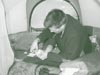
The rest of the day was a slog to Pear Lake which was larger and warmer than Lake Sally Ann. We took some time to sit on the shore, do some laundry, and generally chill in the sun upon our arrival, but as soon as the sun went down the mosquitos and black flies emerged making life outside the tent all but unbearable. Although we cooked outside, we retreated inside to eat and play cards for the remainder of the evening.
At dusk we heard a rustling outside and saw a large deer perhaps 10 feet from the tent. We quietly worked to get out the camera, talking all the while as the deer ignored us. The mechanical sounds of the camera booting, though, spooked the deer and it took off leaving me with nothing to shoot except the moon.
Credit me with another four blisters and another 61 switchbacks.
Lake to lake to lake
We
actually woke early for day four and bailed out of camp quickly to escape the bugs that swarmed around our heads. We planned another easy day (though nothing was easy for me by this time). We wanted to be near the end of the trail at Steven's Pass so our final day would be short, but didn't know how far we'd get. We marked Lake Janus, Union Gap, and Lake Valhalla as possible stopping points. The latter was 12.5 miles down the trail.
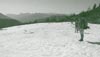
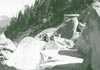
From Pear Lake we descended through an enormous boulder field and across the biggest patches of snow we had seen, though it was only 100 meters across and pretty solid. We passed through the joyless Wenatchee Pass (another bottom-o-the-hill pass) and climbed up past Grizzly Lake to Grizzly Peak where we were again treated to a view of Glacier Peak which we had last seen two days prior.
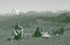
Perhaps the best part about being so far ahead of schedule (we had planned on 12 miles a day each day, but so far had finished more than that on all but one day) was that we were able to relax and enjoy the scenery that so few other people get to see. Who reading this (other than Dan and Nick) has looked across fields of blooming wildflowers to Glacier Peak on one side and turned to the south to see Mt. Rainier? I'd never have though such a vista was possible until I had seen it myself.
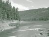
From Grizzly Peak we walked a shoulder between Glasses Lake and Lake Margaret before descending through a tortuous wood full of windfalls to Lake Janus. We filled our water tanks and started cooking a hot lunch complete with cous cous, cheese, and chub, when a group approached us to ask if we were just arriving or just leaving. We assured them they could have the spot when we were done.
We assured the next group that if the first group didn't take the spot, they could have it.
We grouchily assured the third group that if the first two groups didn't take the spot and if we didn't drive them off with pointy sticks for disturbing our lunch they could have the spot when we left, but if they so much as looked at us again there'd be trouble.
We were obviously nearing an access point which allowed larger, less respectful groups to access the trail. Argh.
Although we considered lounging around Lake Janus just to annoy the throngs awaiting our location we eventually relented and headed up the hill to Lake Valhalla. It was a 1,000 foot gain through Union Gap to Valhalla, but gradual until the very end so eminently doable. We arrived at the resting place of the Vikings at around 4pm and set up camp at the far end of the lake which required a perilous scramble along the southern shore, but kept us far from the cretins at the easily-accessed sites on the western edge.
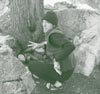
We had a comfortable evening yelling at the picas and playing cards. I tended my feet which were in a deplorable state by this time while we all savored the last night on the trail.
Figure a total of 20 blisters by this time (though some had merged with their neighbors and some even had a second story added to them) and another 32 switchbacks.
Extraction
Our
last day was wholly uninspiring. While the first day's journey through the woods filled us with anticipation of what was to come, walking down the switchbacked hill toward the growing roar of Highway 2 left me with a feeling of "isn't it over yet?" I don't know that I was really ready to be back in the civilized world (or North Bend) and certainly wasn't ready to go back to work.
We climbed down through a boulder field and wide of Nason Creek before paralleling the highway for the last few miles. We totaled 167 switchbacks (more seemed up than down, but that's what perception buys you) over the 60 some miles.
We emerged, dirty, stinky, limping (well, I was) on the north side of the road. Our loving wives were in Leavenworth awaiting our return so we lounged about until they arrived and took us home. Home where the ground is soft and the water still seems too damn hot, but a nice place to be.