Plans abound on the Fourth of July in typical years, but this year there was a lull before the activities started in the afternoon so Tokul and I headed for the hills in the wee hours of the morning. (Ok, it was 7:30 before they left, but that's still early when you're not going to work.)
The drive up to the pass took 15 minutes, but the dirt road from Hyak to the trailhead took another 30 so it wasn't until about 8:15 that we were actually on the trail. Of course, that was only after we drove past it and into Olallie Meadows and realized we weren't supposed to cross the PCT. Oops.
Once we got onto the "trail" (it was more an overgrown logging road) we made quick progress up the hill. The road became an actual trail soon enough and in a very short while we were cresting the hill. Done? Ha! Not yet.
The first false summit was followed by a second and a third false summit. Ugh. The final approach was very steep and passed through a huge field of mountain blueberries which were, sadly, not quite ready for eating. Two weeks more and we'd never have made it to the summit.
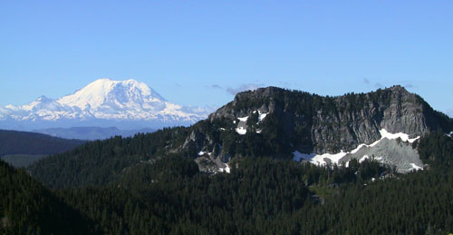
On this trip, however, we got to the top and were treated to 360 degrees of spectacular views under a barely cloudy sky including the rough mountains to the north and Mt. Rainier to the south.
We spent a few moments on top of the world (or at least over 5,000 feet) taking pictures while swatting swarms of mosquitoes. We headed down the 25 switchbacks to the car, grabbed an extra drink of water, then sped home to be ready for the next round of patriotic events.