After a big storm crashed into the Cascades from the west reports of more than a foot of snow and avalanches galore had everyone a tad worried that we (Dan and John) were headed out to conquer Hex Mountain near Ronald on the east slope. We promised we'd be careful (aren't we always?) and headed out bright and early Sunday morning.
After leaving all the skiers (aka: slackers that can't even drag themselves up the hill) behind at the pass we drove to the Salmon La Sac exit, through Roslyn (also known as Cicely, Alaska, to some), through Ronald, and finally to the shores of Cle Elum Lake. The snow had mostly tapered off since going over the Cascade Crest and there were signs we might have a blue-sky day.
We started out well, but perhaps should have considered it an omen that we missed the trail by 300 feet. No problem. The GPS showed us the error of our way (hehe) and we were soon back on track... only to miss the next turn. This time we did a bit of cross country through a pretty little meadow to join back to the trail. Previous to this sample of offroading we were snowshoeing in someone else's trail which is substantially easier than trying to blaze a trail through the three feet of dry powder in the meadow.
Not quite catching on, we continued up the trail toward the summer trailhead for Hex Mountain. At 3,300 feet (we started at 2,400) our trailbreaker had given up and turned back. Now we were breaking our own trail. We switched off frequently so as not to get exhausted. We made pretty good time and were soon standing in the parking lot of the summer trailhead.
Up until this time we were sheltered from the wind from the west, but as soon as we jumped the bank and headed up the spine of the ridge we were face to face with a nasty wind. Below 4,000 feet the winds would gust to about 20mph which wasn't terribly bad. We were able to stay in the trees so although we could hear it we weren't directly affected.
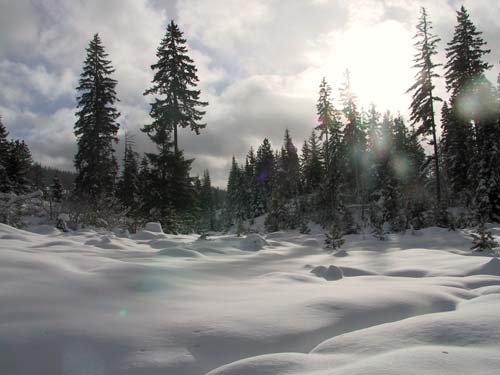
At 4,000 feet we could look at the next portion of the ridge which was completely exposed. The wind had built cornices dropping over 500 feet to the buried creekbed below and whipped the powder dry snow into low lying clouds. The summit of Hex Mountain loomed about a mile away, but still 1,000 feet above us.
We dropped about 40 feet and started to climb again. As we left the cover of the trees we realized just how nasty the wind was on the ridge. 40mph gusts blew the snow horizontally. When the biggest gusts came through we had to turn our backs to avoid the stinging ice crystals. At 4,300 feet we decided we had had enough and it was time to turn back. Specifically, I said, "Dude, we've got to go back or we're going to die up here." "No," said Dan, "we'll die down there," referring to the valley below us. We snapped a few pictures and headed down the hill.
(Seriously, though, we were in no real danger. We always had a tree or 20 feet between us and the edge of the ridge so we were quite safe. Really.)
We made extremely good time on the way down. It's amazing how much easier it is to step into broken trail instead of having to fight for every inch in deep powder. Once we were back in the trees on the lower part of the ridge we ran into the only other snowshoers on the trail. They had recently moved up from Texas and were having a leisurely walk up the hill in our footsteps. After we left them Dan and I had a deep philosophical discussion on how lucky they were not to have to break trail and decided making a new trail was our way of giving back to the snowshoer community. (With the wind blowing as it was, though, it's unlikely our gift was there more than a few hours.)
Hex Mountain looks like it'd be a great little summer hike, though a tad on the steep side. (In summer it's only 1.8 miles to the summit. The snowshoe route is about eight miles.) I doubt we'll try it again on snowshoes. Well, at least not by that route. (The Sasse Ridge trail looks to approach from the opposite ridge... Any takers?)