From the moment I saw Mt. Kent's cliffs from a snowshoe on Mt. Gardner I've had a longing to climb it. When I found a fairly easy route it just remained to con Dan into the trip.
My route followed the McClellan Butte trail to 4,500 feet (about three miles and 3,100 feet of gain) before heading east. On the map, it appeared to be a simple one mile traverse (after a modest 400 foot drop) to the Alice Lakes basin. Then a 700 foot climb up to the summit.
Simple, huh?
Well, the first part was. The McClellan Butte trail was in pretty good shape. There were a couple of muddy bits, but nothing to worry about. Dan, Tokul, and I left the trailhead at 8am with only one other car in the lot.
It took about two hours to get to the last big bend in the trail at 4,500 feet. It's an easily identifiable spot because it's the first place Mt. Rainier jumps up in your face. We had passed the solo hiker that had shared the parking lot with us and knew no one was ahead of us, though we didn't expect anyone to be heading to Alice Lakes or Mt. Kent.
The route, no longer a trail, was bashed through thick undergrowth east of the big bend. When it opened up we were atop a 400 foot high pile of talus. Lovely. We could see where we were headed and there were several more rock slides to cross so we just gritted our teeth and started down. Tokul was not terribly happy about this and whined as we crossed the rocks. She eventually found refuge in a small stand of trees and made good time down.
We popped out of the woods and rocks onto a switchback of a dirt road. The corner we stood on was about all we could legally stand on. The road came out of and quickly returned to the Cedar River Watershed, which is completely off limits to lowly hikers like us.
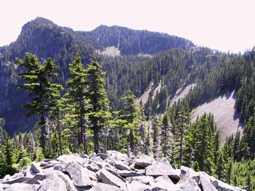
We picked a spot in the thicket in front of us and charged through. We shortly emerged onto the first of three rock slides. The rocks on these slopes were much smaller than the huge blocks of the first talus field. With each step a few rocks would slide down the hill, but in general it was much easier walking. Tokul had no issues and followed close behind.
Between each of the three slides were a few trees that were slowly reclaiming the ground. At the end of the last slide we felt accomplished and fairly happy to be on solid ground... until we realized we were now forced to push through slide alder, blackberries, huckberries, and young trees. Oh, for rocks under foot.
We caught a glimpse of water below us and considered continuing high toward the upper lake, but when we saw the Watershed boundary signs we turned down the hill toward the lake.
Lower Alice Lake is a pretty lake. Quite small, but crystal clear. It's at the bottom of a 700 foot high rock slide that leads to Mt. Kent. Tokul went for a swim and we doused ourselves with 100% DEET to defeat the swarms of mosquitoes that appeared out of nowhere. It'd taken just over an hour to fight our way to the lower lake.
Around the corner is a little puddle and another set of thick woods leading to Upper Alice Lake. We started toward where we figured the upper lake must be, but decided instead to make a bid for the summit in spite of the daunting climb up the rocks.
Turns out it wasn't that bad. Perhaps the promise of getting to the top was enough to encourage us along. It took under an hour to climb the slope. Woo hoo!
Once at the top the views opened up across the South Fork Valley and beyond into the Alpine Lakes Wilderness. We saw tons of goat/sheep sign and hair on the branches and rocks. Dan looked at his watch and realized it was highly unlikely we'd be off the hill or anywhere else in the next 40 minutes, aka 1pm, aka his declared return to Snoqualmie.
Oops. Out came the cell phone for a call to Jenn. He figured at least two more hours to get down and back to the main trail and another hour or so to get back to the car. Given that aggressive schedule we finished lunch and headed down.
I had far more trouble than Dan or Tokul going down, but it wasn't a big problem. Plus, it gave me the opportunity to shoot pictures with subjects other than nature. Dan's only trouble came while rounding the lower lake when he went calf-deep a couple of times.
We decided to stay lower than on our trip out and did much better. The early section along Alice Creek was a bit dicey, but once we got on the rocks we made great time. We emerged on the road at almost the same spot we had departed it in only an hour from the top of Kent.
The final off-trail portion was to climb back up the talus field that had caused Tokul so much trouble. Dan decided to just climb straight up. I guided Tokul into the woods, but they soon petered out and I had to start coaxing Tokul up. She started whining and a couple of times turned downhill. On went the leash and I pretty much pulled her up to the top.
Once there I found Dan again on the phone. Geez. Here we are way out in the woods having a great time off-trail and he can't cut the cord.
Oh. Turns out it was Amy. Dang.
Before I arrived to take over the conversation Amy asked whether I was hurt, how lost we were, what boondoggle I had taken us on. Dan responded well in each instance except he let slip that I was currently engaged in a climb up a talus field.
THAT'S HOW HE GOT HURT LAST SUMMER! (Amy was referring to a climb near Williams Lake up the Middle Fork that resulted in surgery.)
Once she realized I wasn't falling up another mountain we hung up and got on the actual trail. McCellan Butte was clearly a popular destination on a holiday weekend because we saw a stream of folks on their way up. At the trailhead there were oodles of cars. One group, drinking beers, asked where we'd been since they hadn't seen us on the trail or at the top. When we mentioned Mt. Kent they seemed a bit surprised, but left us to drag Tokul the rest of the way to the car and strip away our sweat-soaked gear.
In the end it was about 10 miles and 5,000 feet of gain. The main lesson was that in planning we should use satellite maps to look at specific terrain (such as rock fields) and that the dogs probably shouldn't accompany us given Tokul's difficulty on rough terrain.