This was supposed to be our annual training hike for the PCT, but it was Katherine's birthday weekend so Paul was out and Dan's broken and in California to boot so that left just me and Nick to do stupid things. Ooh, and I do mean stupid.
The plan was to start from the Dutch Miller trailhead at the end of the 25 mile Middle Fork road which has been described as something between barely passable and absolutely horrendous. We'd hike 10 miles the first day (gaining 3,000 feet) to camp at the Chain Lakes. The second day would be mostly down hill for 16 miles to a waiting truck at Cooper Lake.
Friday evening I conned my dear, fishing-obsessed father into acting as shuttle driver to get my truck to Cooper Lake before doing a bit of fishing. Even though we left earlier than expected (3pm thanks to the New Media bosses kicking us out of the office on a sunny Friday) we still only got about an hour and a half of fishing in when you factor in the driving time and dinner at the Brick. Still, the upper Cle Elum river was full of small rainbows and brookies who could no more help themselves hitting a royal coachman than they could swim.
Saturday morning, Nick arrived on time at 7:30. Amy, Clara, and Tokul were already in Kirkland with her parents so I had a very quiet morning putting the final touches on my pack. In the end, even with the tent poles, I don't think I topped 45 pounds. Compare that with 65 pounds on the PCT last year. What an improvement!
It took an hour and a half to get to the trailhead, but that was a heck of a lot better than I had worried it would be. The road from the Taylor River bridge to Dingford has traditionally been extremely rough. So much so that after taking their Subaru up there Dan wisely chose not to risk the trip again relegating that section of the road to a high clearance vehicle instead. The Forest Service, though, has spent what must be a billion dollars on the roads recently because from the National Forest boundary to Dingford the road is smooth and nearly without flaw. (The county section, though, is still a mess with vicious potholes in an otherwise deceptively smooth road.)
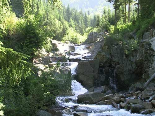
To Dingford was 18 miles and took 45 minutes. The next 7.5 miles to the Dutch Miller trailhead also took 45 minutes of brutal bouncing and technical off-roading in Nick's Trooper. The road had huge mud holes (or what would have been mud holes if the sun hadn't baked them dry), pointy rocks dying for a transmission (with chips taken off them attesting to their height), and killer views across the Middle Fork. The river was way below us for most of the drive, but then suddenly it was there. Clearly there's a huge falls in the river, though we couldn't see it from the car. Surprisingly, there was a Camry parked in the lot so somebody was able to get up there without a truck, but I wouldn't do it.
We gathered our gear and were on the trail by 9:30am. The trail is in great shape with lots of recent work and plenty of flags marking future work. It winds through the woods between the steep slope and the river as the Middle Fork gets progressively more beautiful. You'd never guess what a great river the upper Middle Fork is based on the look of the lower river which is a plodding behemoth rampaging through North Bend.
We pumped water at a crystal clear spring in the middle of the trail home to a frog. The water appeared from one side of the trail and disappeared on the other side. It was the best water of the trip. By 12:30 we were at a split in the trail. To the right was Dutch Miller Gap and to the left was the series of lakes we planned to use for our campsites. We turned up toward Williams lake and 500 feet later voila!
Williams is a pretty lake, but we were planning to camp at the Chain Lakes... or at least we were until the crazy old guy we met earlier in the day told us the Chain Lakes were lousy. "La Bohn Lakes are just a bit beyond and they're really nice," he said before launching into a thinly disguised tirade about the Forest Service's plan to close the road at Dingford. Still, the Chain Lakes were on our way to La Bohn Lakes so we skirted the east side of Williams looking for a way through the solid rock wall that blocked our path.
We stumbled on an old mine shaft mostly full of water about two thirds the way around and happily a little trail heading up into the woods. The trail quickly petered out and we found ourselves on the edge of a huge boulder field. Cairns marked a path of sorts through the field so we started the climb. I was carrying my trekking poles which are great on trails, but lousy on rocks.
Everything was going well until-
Wait. Stop. Why does there always have to be an "until" or a "but" in all these stories? Huh? Really? Why the heck is there always some tragic event?
<shrug>
Everything was going well until the boulder flipped out from below me. Don't worry, it didn't start a rockslide or even move really far, but it did help me to drop a few feet. Now I was face to face with a depression in the field and the pack which I previously thought was really light pushed me into the hole. Sadly, my right arm was extended trying to grab anything that resembled a handhold so it stayed out of the hole bending backward all the time. I dropped my poles, felt my back spasm, smashed my left shin into the rocks, and bruised the hell out of my right thigh. All in about half a second.
"You OK?" asks Nick from about 20 feet above.
"Not yet," I reply as though a few seconds from now I'll be ok. I was pretty sure my arm was broken due to the pain and had to fight back tears and nausea. I pushed back and spun around so now my pack was in the hole and I could cradle my arm. It wasn't broken, thankfully, but perhaps I know a little bit about what Dan feels when his shoulder pops out of socket. DAMN. I sat like that for a few minutes trying to regain my composure before I noticed the blood running down my leg or that Nick and climbed down to check me out. He took my poles and... we started up the rocks again. (You didn't really think a fall like that would stop us did you?)
UPDATE: The fall was officially classified as a "rotater cuff strain," but not a tear. Woo hoo!
UPDATE II: The fall was officially re-classified as a "superior labral tear" that requires surgery. Boo hoo!
It took another hour to get to the top of the cascade of rocks. We looked around to see... more rocks. And snow. We were at about 5,200 feet and the 80F sun bounced off the rotting snow, but at least we were closer to where we needed to go. We trekked on and crested the next ridge to see another ridge. Guess what came after the next ridge?
No, silly, it was the Chain Lakes. About four or five lakes all chained together (get it?) by little creeks. The water came from waterfalls and melting snow. The map and the crazy old guy both said there had been mining in the area so we took the red nastiness coating the rocks by most of the lakes to be a bad thing and decided that although we were low on water we would pass and continue up to La Bohn Lakes. A group of women hikers and a dog were filling up and we did see them later so I assume the water wasn't immediately poisonous in spite of it's red color.
(We actually did fill up at one of the upper Chain Lakes which had no red in it. I thought the water was kind of metallic tasting, but after the spring/frog water on the Middle Fork trail nothing would taste good.)
We climbed another few hundred feet to crest the next ridge (and the one after it) to peer down on the biggest of the La Bohn Lakes. Gorgeous, defintely. A good campsite? Yeah... no. Everything around it was solid rock except for two exposed knolls. We chilled at one, but then started thinking about what would happen if it rained (going down the boulders would be perilous), the wind kicked up (we'd find ourselves in a flat tent at 6,000 feet), or needed to get water (it looked way too far down to the water). In the end, we had a tasty snack of peanuts and turned around.
The way down was a lot easier than the way up. Another group had followed us up and made camp near the Chain Lakes in probably the only spot available. We actually found a real trail that switchbacked down the wooded part of the hill so we didn't have to worry about the boulders on the way down. The trail dumped out right at the very same mine shaft we had started up at. Oh well.
We camped on the northern edge of the lake. Dinner was a tasty Beef Stroganoff (freeze-dried, of course) and beefy-pork top ramen. Between the two we got almost 100% of our RDA for sodium which is actually good because I had almost none the rest of the day. Looking back I had eaten grapenuts for breakfast, a mocha on the way to the trailhead, and little more than half a bar, a handful of peanuts, a strip of fruit leather, and about eight liters of water. Unlike previous hikes I didn't have the dehydration blues, but did have to contend with a very sore body. We went to bed around 8:30 as the sun was still setting. (8:30? Really? Yeah, even though it was only 10 miles or so the climb up and down from La Bohn Lake really took it out of us as did the wicked nasty heat.)
Nick woke up at some ungodly hour and tried to convince me we should get ready to go. He admited it was earlier than 6am so I went back to bed. Unlike previous mornings on the trail I didn't have to spend more than a few minutes prepping my feet. I had only one very minor blister where a toe sleeve had slipped off so I was a happy camper.
We had cocoa and various other snacks for breakfast and were on the trail by 8am. Heck, we were actually at the junction with the trail to Dutch Miller by 8am! As usual, the first climb of the morning is always hard for me and this was no exception. The Gap was only a 600 foot climb along the tumbling Middle Fork, but I was beat and took almost half an hour to get up there. Ugh.
We crossed from the west to east side of the Cascades with the sun blasting us in the face. The source of the Middle Fork is a lake high above the Gap, but I dunked my head in the pools at the base of the waterfalls for refreshment anyway. Just a hop, skip, and a jump away we were at the source of the Waptus River, aka Lake Ivanhoe. It's a gorgeous lake with sheer rock walls and water falls dropping into it. Since we had only just begun the day and had a ways to go (16 miles total on the second day) we trucked on past the deep blue waters with only a few pictures.
At the outlet was a rickety old bridge that looked like Galluping Gertie down in Tacoma frozen in time. One side seemed stable enough so we crossed there and continue downstream. The river dropped away from us and in the distance, five miles and 2,000 feet away we could see Waptus Lake. The trail down was hot and dusty and full of nasty switchbacks. I'm certainly glad we went down it instead of up, though going down wasn't much of a picnic either.
Our trail intersected the PCT for about half a mile before diverging again to follow the lake shore. We stopped for water briefly, but continued at a quick pace. Horses can ford the Waptus at the outlet of the lake, but the foot bridges are a ways down stream which added about a mile or so. We were now definitely in horse territory, unfortunately, so the trails were beaten to dust and covered with horse piles and flies. Lovely.
From Waptus Lake we had to climb up to Waptus Pass, about 1,200 feet up. I again fought with the hill and the heat to get up, but with much of Nick's patience did make it to the top just in time to head back down the other side to Pete Lake. The trail really degraded and we saw the first horses on their way up to Waptus Pass.
When we got to Pete Lake, or more specifically the junction with the Pete Lake trail, we decided to just head to the truck rather than stop at the lake. We were only five miles away and it was just a 300 foot drop to the parking lot. No problem, though it sure seemed like we'd already hiked way more than 11 miles.
This last bit was no fun at all. No views, little water, and tons of horses. As we got closer to Cooper Lake and the campground there we saw more and more families who clearly thought a short hike to Pete Lake would be a good afternoon activity. I wonder how many actually made it. We stopped one last time for water and were swarmed by flies. I pumped only a liter in order to get going as quickly as possible and shortly we were back at the truck.
I had several nasty blisters, probably from overdoing it. Turns out it wasn't 16 miles at all. More like 21 miles. Oops. Although 21 miles is still a mile short of my daily record (22 set on the first day of the PCT last year) it was still way more than I had intended and my feet were paying the price. We had hiked for over eight hours without much of a break except maybe a few minutes here and there sitting on logs. I only took my pack off to pump water.
On the drive back we stopped at Safeway and Burger King in order to get some food and soon found ourselves back in North Bend. It took another three hours to go up and get Nick's truck from the trailhead so I got home after 9pm. Nick called shortly after that to say he'd made it out safely as well.
All in all, a good trip in spite of my fall and the bad planning that resulted in an extra five miles. My feet are still torn up (just in time to do some hiking in Vermont), but they will heal. My boots are completely thrashed, though. They are separating from the sole so although I was trying to baby them through the rest of the season it looks like I'll need new boots sooner than later. Dang.
My recommendation: Hike from the Dutch Miller trailhead to Williams Lake for the night. The next morning, hike up to the Dutch Miller Gap and maybe to Lake Ivanhoe, but then turn around and come out the way you came in. There's just nothing to see on the rest of the trail.