This is a pretty close approximation of my packing list for our Arizona trip:
T-shirts
Shorts
Swim trunks
Sandals
Camera
Snowshoes
Ice axe
Crampons
Gaiters
Puffy
Hardshell
Balaclava
Gloves
Long underwear
Sleeping bag
Bivy Sack
Amy took a look at my list and told me I was doing it wrong. I asked her if I should bring my helmet, too. She shook her head and walked away.
It's true that maybe I overpack sometimes. Usually it's not 50 pounds of gear that seems anathema to the reason most people go to Arizona.
You know, Arizona where the temperature (except when we're there) gets no colder than 70F? Arizona where you lie by the pool? Arizona where your biggest concern should be carrying enough water?
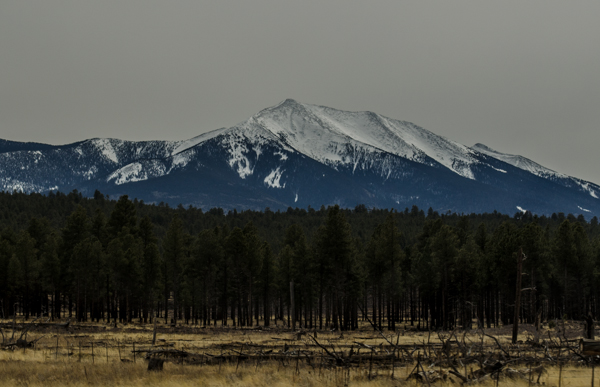
This time I was completely off the rails and headed for Arizona's highest point, Humphrey's Peak at 12,633 feet above sea level. Luckily, I wasn't going solo. I'd found some other similarly affected folks to go with me.
Jes: Arizona native with volumes of knowledge about peaks large and small. She'd climbed Humphrey's several times in summer. She also provided us the recommendation to go to the White Tank Waterfall.
Chris: California climber with tons of experience around the world. He'd climbed Humphrey's once before in winter. He's the co-host of In Ice Axe We Trust, the podcast I appeared on in October and that Jes has appeared on multiple times.
Jon: Arizona native. Hikes with Jes a lot. Doesn't do social media. Nerd. We got along great.
So how'd I get set up with these folks? Twitter. I know, I know. One of these days I'm going to meet someone online that's going to ruin my life. If it hasn't happened by now, I think I'm gonna be ok. Besides, I'm probably the one that's going to ruin someone else's life.
Thursday evening, Amy and the kids dropped me off on the side of the freeway just north of Phoenix. That's where I was scheduled to meet Jes for the two hour drive to Flagstaff. We picked up Jon one exit further along. That night we slept in the parking lot of the Arizona Snowbowl.
Yes, Flagstaff has a ski area. Yes, that means the groomers were going pretty much all night long. Beep. Beep. Beep. Beep. Rumble rumble. Beep. Beep... Beep Beep. Still, I slept ok except when I was sure something was snuffling around my bivy. (Jon heard it, too.) Jes missed out since she was sleeping in her truck. Chris hadn't arrived yet. (Wait. What time was this? Dunno, but Chris didn't arrive from a seven hour drive until about 4am.)
We started at the leisurely hour of about 7:30am. The trail was well trod with only a few inches of compacted snow. We made pretty good time for the first bit in the trees. At a talus field we found a set of prayer flags on our side and an orange ribbon on the other. Clearly the trail crossed the rocks here.
I demonstrated proper trekking pole technique and managed to avoid all the voids in the lightly snow-covered rock field. Even Chris, the standard bearer in the war between ice axes and trekking poles had to admit they were handy in this situation. (I'm an equal opportunity tool user. I had an axe strapped to my back for later.)
Beneath the orange flag on the far side we couldn't find the trail. Nor was there another flag in sight. Clearly, though, the trail must go up. If we followed the rock field up we'd find the trail again. (Clearly, anytime I use "clearly" I'm being sarcastic and it's clearly going to lead to disaster.)
The rocks petered out and we were left with knee-to-hip deep snow. No problem, I just put on my snowshoes... oh wait. I left them in Phoenix. After packing them all the way from Seattle, I decided the extra weight would be a waste. We had so little snow this year back home and the one time they honestly would have come in handy and I'm left postholing my way up a mountain. Not my finest hour as a Tubbs Ambassador.
Breaking trail in deep snow, especially wet snow like we were in, is exhausting work. We traded off to prevent any one of us from getting too hammered. Worse than the wallowing was the three firm steps followed by a sudden and unexpected descent to the hard pack beneath. Gradually, we found our way to harder snow and our pace picked up.
At another rock field I spied "something shiny" on the far side. Getting closer I could see it was metal. Lots of metal. It was a wing. Whoa. We'd stumbled on the site of a B-24 Liberator that had crashed in WWII. It was somber to think of the final moments of the crew before they smashed into the hillside. Had there been much more snow we would likely have passed by without noticing. Much less snow and we'd have been on the actual trail.
Above the crash site the trees opened up and the snow became harder. Chris and I readied our axes and put on crampons. Jes and Jon got out their axes and rented crampons, but... how do you put these things on? I chuckled and got on my knees to help these silly southwesterners with a piece of mountaineering gear they should have already... Hey. Uh. How do you put these things on?
They weren't full crampons, but only the front six points. The instructions were a cross between Lego and Ikea, but without as much sense. I tried a bit, but they came off when Jes started climbing. We eventually got them mostly on or at least on enough that they wouldn't fall off. We did the bare minimum ice axe training (and I mean minimum, even omitting the fact that you should switch hands so the axe is always on your uphill side) and then started up.
We were at about 11,000 feet and I was starting to feel it. A lot. I've never felt the effects of altitude, even at 14,000 feet on Mount Rainier, but this was destroying me. I had a headache, a touch of dizziness from time to time, and a little bit of nausea, too. It was manageable, but I felt like I was really, really slow. Chris waited for me a lot.
When we finally reached the summit ridge we knew we had only a bit to go. There are four false summits on the summer route, but we'd cut one of those of with our direct approach. We painstakingly picked our way across the ridge with exposed rocks everywhere. It grew windier as we climbed the last summit, but upon reaching it we had all the southwest to see.
North was the Grand Canyon, just visible. South was Agassiz, Humphrey's sister on the wrecked crater rim. (Did I mention Humphrey's is the highest point of an old volcano?) Everything else looked so flat. Everywhere I climb the summit I stand on is just one of many. Sometimes it's the tallest around (Rainier, Hood, South Sister), but there's almost always mountains nearby. Humphrey's stood almost alone.
We snacked, ogled, and layered up. Pretty quickly, the wind made it genuinely unpleasant so in spite of the views we headed down. Even the descent, usually much easier than the climb, was hard. The snow was softening so postholing was more of a concern. We opted to head down the summer trail and found it to be much longer, but a much gentler option than the way we'd come up. We even got a few glissades in.
What I appreciated most about this trip was seeing yet another aspect of Arizona. In the trees and on the summit I felt like I could have been back home. Looking around, though, and it was clear I wasn't in Kansas... er... Washington anymore. My guides were awesome and showed they are capable mountaineers. I know next time I head to Arizona I'll be trying to set up another adventure with them. And if they ever come to Washington, I hope they'll give me a call, too.
More takes on this climb:
In Ice Axe We Trust podcast - Listen live on March 26 at 6pm PDT.
Jes' post on this climb
Chris' post on this climb