Surely, you remember the plan, right? Climb six big peaks in Washington before I get old. Last year I got Mt. Adams and earlier this year tagged Mt. St. Helens. To stay on track I needed to get to the top of Mt. Rainier this year.
When we started planning it was me and Scott and Rich. We did some backyard crevasse rescue practice with Rich, but life being life meant that Rich had to drop out. Two people on a glacier is a bad plan, but luckily Scott recruited a couple of TNAB hikers to come with us: Tom and JK.
Our first attempt was scratched almost a week before it was scheduled thanks to a late season snow followed by high temperatures prompting a special announcement from the avalanche forecast folks. The mountain would not be fit for climbing. Instead, Scott and I climbed up Mailbox Peak. When we got our first views of Rainier Scott pointed out that it would be right about that time that we would have been summiting. Needless to say, I was none too pleased.
Two weeks later the weather was looking mildly ok. Certainly not the bluebird days from our first window, but doable. Scott returned from Whistler early and we met Tom and JK for the two hour drive to the Park on Friday afternoon. It was cloudy when we left home, but when we got beyond Enumclaw there was more blue than white in the sky. Good things to come?
At the ranger station we filled out forms, paid our dues, and got some last minute advice on the route. The ranger seemed out of place dealing with the computer and the credit card terminal, but clearly enjoyed seeing folks like us get on the mountain, though he felt our three day trip was a little short. A guy just behind us, though, was having a tough go since his party wasn't all present and the ranger proclaimed that as a government employee he didn't get anyone's money, but he did have a little bit of power he could lord over people if he was so inclined. We left before his inclination was fully expressed.
It's a short drive from the ranger station to the White River campground where we'd park. We made it longer, though, when we saw a bear on the side of the road and circled back for a photographic extravaganza... with our lousy cameras. All the good gear was packed in the back so we tried our best with iPhones and Blackberries. I definitely captured the bear's similarity to a large brown blob, but that's about it. (Notice there are no pictures of the bear.)
The trunk, barely able to contain our gear, finally let loose all over the parking lot. We divided group gear and shouldered our heavy packs for the short evening hike. We're all accustomed to fast night hiking, but we opted for a more leisurely pace to the Glacier Basin backcountry campground. It was only a few miles and not even 2,000 feet of gain, but with loaded backs we allotted a couple of hours.
After feeling like I had the hang of my mountaineering boots on a snow-free trail I left my regular boots at home. I was the only one in plastics and I hoped the discomfort on dry ground would be erased by the comfort up higher. (Plastics rarely get wet or cold, but are pretty inflexible making hiking on a regular trail a jarring experience.)
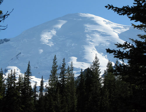
We arrived at Glacier Basin right on schedule and after poking around a bit we settled on a site right by the trail, but close to the food hangers (a tall pole with hooks for hanging food away from curious animals) and views up the Inter Glacier.
Before I could get settled and take pictures a fog rolled in and I figured that was the end of our clear skies. We made dinner and melted snow for the morning. Some time while that was going on the fog cleared and the moon lit up the hills. Dare we hope for good weather?
We woke a little after the sun and packed up after breakfast. The pack always seems to feel heavier the next day and this was no exception. We were granted blue skies again and liberally applied sunscreen. After getting cooked on Helens I was particularly careful to ensure I was evenly covered.
With a thick covering of snow that started well below Glacier Basin it was hard to see exactly where the glacier began. Though not usually thought of as a particularly dangerous glacier, we wanted to be safe and rope up when prudent. (Plus, the sooner we roped up the sooner the rope wouldn't be attached to my pack.)
Half a mile from camp, while tromping up through the snow, I saw a set of prints that weren't human. They kind of looked like a goat. I pointed them out to Scott, then looked around. On the flank of Mt. Ruth was my first wild goat sighting. Yee ha! Since failing to spot them on the Ingalls Lake trip last Fall goats have been my nemesis. I guess now I need a new one.
Shortly after seeing the goat we roped up. It's about the same spot Scott and I roped up when we climbed to Camp Schurman just under a year ago. Then, the snow was much less and our plan, in case of a crevasse fall, was to hold on and cry for help. Not exactly ideal, but it wasn't a deserted route. This year I felt far more prepared. Aside from more people on our team with four Rainier summits between them I'd memorized the steps for performing a rescue. Scott and I had practiced it on Mt. Margaret and even that false rescue had cemented the steps in my head.
Due to my inexperience on glaciers I clipped in to the rope second. Scott led and was most likely to fall. I'd get to arrest the fall and JK and Tom would be in charge of setting up anchors and most of the rescue. Plus, I'd be able to yank on Scott to tell him to slow down. Second position rocks.
We climbed pretty much straight up, getting used to the rope and how we worked as a team. There were no open crevasses on our route, which pretty much followed the glissade track. We made decent time and were soon at Camp Curtis about to descend to the Emmons Glacier.
Rainier was fully exposed at this point. We could see the tracks of hundreds (thousands?) of other climbers up the main route and a few tiny black specks heading down. Clouds were few and far between, but wind was up high. Below us we could see a few open crevasses, but nothing threatening our path. We easily skirted the edge of a couple and stepped over another before arriving at Camp Schurman.
Last year Camp Schurman was our destination. It had the feeling of a summit on a day hike. (And at just over 9,000 feet that's a decent summit.) This time it was just another stop on the way to the top and seemed miles below our destination. (Interesting note, it is almost exactly a vertical mile below the summit.) We looked around and got lucky with perhaps the best site in the "campground" of snow. Scott and I set up in a big, walled area and only had to smooth the floor and dig a pit for the vestibule. Tom and JK got the spot right next to ours after its occupant left. We set about melting water, making food, and resting. I got about an hour's nap, but the sun turned the tent into an oven limiting my snoozing.
Waiting to go was hard. I spent time packing my gear and double checking what I'd be taking up to the top. The tents and most of the overnight gear would stay at Schurman, though we had agreed to split an emergency bivy and stove between the four of us. Deciding what to wear was a challenge as well. Too much and I'd sweat even in the cold and then chill out when we took breaks. Too little and I'd freeze even when climbing and then really suffer during the breaks. I settled on several shirt layers and my hard shell, but the down coat went in the pack. I stuffed fleece pants into my dry bag, too, and hoped my legs wouldn't get too cold with just a base layer, shorts, and waterproof pants.
After gorging on food in the hope it would digest before we started the climb I finally fell asleep about 7pm. We had multiple alarms set for 11pm, but it was Scott getting ready that actually woke me up. It surely didn't seem like it took an hour and a half to eat a small meal and gear up, but it was 12:30 Sunday morning when we finally took our first steps up the mountain.
The moon was up and nearly full, but all I recall seeing was the cone of white created by my headlamp. There seemed a swarm of rope teams starting out. Scott set a good pace that wasn't going to win any sprints, but would hopefully get us to the top. We were spread out along a 50 meter rope so we didn't talk much to each other. In fact, I think I talked more with other teams as they passed us or we passed them (there was lots of leapfrogging).
On a regular hike (or climbing the stairs at work) I've practiced rest-stepping where I'd take a step and rest, then transfer my weight and repeat. At lower elevations it was always a challenge to force myself to wait. Now (and increasingly as we got higher) the pause was forced upon me. At about 11,000 feet was the sweet spot where I wanted the rest with each step and it the rhythm of the rest step just worked. Step, rest, step, rest.
We were above Little Tahoma when the sun finally rose. Probably around 11,500 feet. The slopes turned pink and then dusky red against the dark blue sky. We were making good time and had seen a few teams drop away. Above us we could see faster teams nearing what looked like the top, but really wasn't. We took more breaks to drink and eat and just rest. Headlamps came off, but all our layers stayed on. The wind was picking up.
Down below 10,000 feet we had deep steps already kicked for us. Here the snow was hard. The spike of the axe would usually penetrate the crust, releasing a puff of powder that was stolen by the wind. The steel squeaked as it slid in. Sometimes the snow would reject the axe and it almost bounced off the surface. A second thrust was required to get any purchase. These areas of hard snow were usually easy to spot because the only prints would be 10 points outlining a foot where even our crampons barely dug in.
More teams were struggling as we passed 12,000 feet. We leapfrogged with a team with a member suffering dry heaves. When they'd stop for a rest (fairly frequently) she'd put her head close to the snow. I tried it once and was surprised at the amount of snow being blown within a foot of the ground. Higher it wasn't present, but my helmet was being sandblasted when it went below my knees.
At 13,000 feet I was higher than I've ever hiked. From 11,000 to 13,000 seemed to take forever. We were traversing to the west and our rate of climbing decreased, but the effort was far less. We crossed a soon-to-be-open crevasse in this stretch. The snow was light blue and my axe went through the bridge. We stepped long across without any problems.
To our right was Liberty Cap. We'd joked that maybe we'd tag that since we were up here anyway, but the prospect of dropping elevation to the saddle and then climbing out (both ways) was appalling. It's a good thing we were only joking.
At the bergschrund we took care and made sure everyone on the team knew when one of us was crossing. The bridge was steep enough we used our axes to climb. Looking at pictures you can see a crack forming. That route might not be there for much longer.
Higher still we were following wands marking the route. The steps were more labored. The breaks were more frequent, but not much longer. It seemed harder to recover anything when we stopped. Just below the summit we got to a section of exposed rocks. Tiny volcanic rocks under a fragile crust of snow and ice. A team coming down assured us we were almost there. The only sound was the screaming wind (now about 50-60 mph) and the clank of axes and the tortuous scraping of crampon teeth on the rocks.
We crested a little hill and a sudden cloud bank enveloped us. Views opened and closed as the wind whipped it around. We could see the summit hill, but it looked miles away. Then the clouds broke and it was clear the summit was just a few feet away. The last few feet were quick, but anticlimactic. It was 9am.
The views weren't there. We could barely see the crater rim and the way to Point Success on the opposite side. Liberty Cap was only just visible. There was no benchmark to stand on and no shelter to be had. It felt like a real mountain experience. Tom's nose was half white with the early stages of frostbite so we headed down after only a few minutes to shoot pictures. A few hundred feet below the summit the wind was much less and Tom's nose was back to a normal color. I tried to take a summit shot, but my batteries failed and instead of taking the picture the camera shut down.
Climbing a mountain is half up and half down and unfortunately, we had the down part to go. 5,000 feet of it just to get back to camp. We reversed our order and Tom led down. Some sections were remarkably easy. Others were much harder than going up. Far, far below we could see Steamboat Prow and if I squinted I could see a few specks of color that were our tents at Camp Schurman below the rocks.
We passed a couple of teams still heading up, but saw as many if not more who were turning around short of the summit. Crossing the bergschrund a team leader was apologizing to his team that they wouldn't make it, but they all seemed ready to turn for home.
I hadn't noticed all the wands on the way up, but heading down we could see a ton of them. Some of them were off the route we had come up and we had to consult GPS tracks to be sure we were heading in the right direction at least once. On my pack I had a big batch of wands that Scott had fashioned. Later we realized we should have been placing them on the way up to ensure our route was well marked.
Much lower we started seeing skiers. They were effortlessly (or so it seemed) zipping down the mountain faster than I could imagine going. What a temptation when we would see pitifully slow progress over the next four hours.
As we neared Emmons Flats (a little camping area 300 feet above Camp Schurman) clouds rolled in and hid everything. The wind picked up again and blew them away, but then they were back. We dropped our packs and unbuckled our harnesses and were happy to be back at camp. I had trouble getting too thrilled, though. I couldn't get the idea of the slog back to the car out of my head. The ranger's admonishment about our short-duration trip came back to my head. It truly would have been awesome to get to lounge at Camp Schurman for the rest of the day and head out the next morning.
We didn't sleep, but did spend a couple of hours relaxing and then packing up. Shouldering full-weight packs was terrible, but we had only a small climb ahead of us to get from the Emmons onto the Inter and we were in no hurry. Fresh faced climbers were arriving in camp and we wished them luck even as it seemed the weather was changing.
And it was changing fast. When we go to Camp Curtis at the edge of the Inter Glacier we could see little. The entire basin was full of clouds pushing their way up the mountain. We started down into the gray, following mushy tracks in the snow.
When we found the glissade chute we gave in to temptation and sat down. One by one we disappeared into the fog. We dropped an insane amount of elevation in a very short time and wound up near the bottom of the glacier. My GPS clocked me at a top speed of about 13 mph. JK's pack was too wide for the chute so he held his pack in front of him as he glissaded. Apparently, in Norway backpacks ride you. (And later we found out that bronchitis was also accompanying JK on this trip.)
It wasn't long from the end of the chutes to Glacier Basin and only another three miles to the car, but those three miles, and especially the mile and a half with no snow felt terrible. My boots rub on the front of my ankles so I was a bit sore there when we were back at camp. I opted not to take off my boots for fear I'd not want to put them back on. (Not that I'd have a choice.) Each step was less pleasant than the last until we were in the parking lot feeling the hard concrete with every bone in my body.
My pack was unceremoniously dumped on the ground and I grabbed my clean clothes from the car. A bit of water splashed in my face and I felt renewed. Unfortunately, sitting in the car for a few hours gave me time to tighten up and when we stopped for dinner I was a ball of pain. Luckily, I snoozed a bit back to my car and, also luckily, didn't sleep at all from my car to home.
All my gear inside, I grabbed a shovel and started excavating around our septic tank so the guy coming to look at it Monday morning wouldn't have to get too dirty. It's not like I was going to get any nastier. Three days of sweat and grime covered me and a shower was just around the corner anyway.
Looking back I don't know that I'm eager to climb Rainier again via the Emmons route. Just a few days afterward I started thinking some of the other routes would be fun. Maybe even some from Paradise. I always felt that side of the mountain didn't feel as wild as this side, but now that I've gotten my fill of wilderness I'd be ok with the shorter route. Of course, I've got three more peaks on my list before I'd think about returning to Rainier. Maybe it'll make an appearance on the second version of the list along with non-Washington volcanoes.
Stats:
Friday night from White River Campground to Glacier Basin: 3.4 miles and 1,900 feet of gain.
Saturday from Glacier Basin to Camp Schurman: 2.8 miles and 3,900 feet.
Sunday from Camp Schurman to the summit to the White River Campground: 10.1 miles and 5,500 feet of gain.
Bonus features:
More of my photos
Scott's photos
Tom's photos
JK's photos