Last year Jeremy and I climbed to Camp Muir at 10,000 feet on Rainier to experience what it was like to hike at that elevation. I'd been that high only once before, but the hike wasn't strenuous and it was years ago. The climb to Muir is accurately described as a slog. Sure, the mountain is gorgeous and almost on top of you, but it's just one foot in front of the other without much concern besides breathing. I'm sure the lousy weather didn't help much, either.
So imagine my delight when the 30% chance of thunderstorms predicted for this trip turned out to be 100% cloud free. It almost made getting up in the wee hours easy. (I said, "almost," because it's never easy.) I picked up Scott a little after 5:30 and we were on the road south with a trunk full of gear.
An hour and a half later we were at the White River campground on the north side of the park. The day-use/climber's parking lot was crowded, but we found a spot. I changed into hiking boots and started looking at the boots Scott brought for me to try. Real mountaineering boots. Big, heavy, and orange. They fit well enough that I threw them into my pack (thank goodness for that big pack) and soon we were tromping along the three mile trail to Glacier Basin.
The Glacier Basin trail is one that was severely damaged in the 2006 floods. Large sections of the trail were completely washed away so the new trail spends some time early on weaving through the flood's debris. Still, it was a pretty easy route to follow. We established early in the trip that it wasn't to be at TNAB pace (Scott's a regular Thursday night hiker), though the gain was so gradual we probably could have. We saw a bunch of bear poop (and in fact others got great pictures of the source of that poop on the same weekend) as well as various little rodents and birds and a few more than a few bugs.
At the Glacier Basin campground there were only a few tents and people milling about. It was about 10am and we'd seen glimpses of Little Tahoma (that bump on the left of Rainier when viewed from Seattle) and the summit itself though the latter was covered by a lenticular cloud that apparently frustrated the heck out of climbers who were on the summit.
We passed the sign that indicated the trail was not maintained beyond that point and ran into a couple of folks maintaining the trail. (Oh... they meant it wasn't maintained by paid workers. It was the volunteers that deserved our cheers beyond the sign.) We got some great advice from the volunteer and continued on. The way was a little steeper, but not too bad. I saw some marmots... um... playing, but they ran off before we could get too close.
By this time the wide valley of the White River had given way to a narrow snow-filled valley. Mt. Ruth was on one side and cliffs below Burroughs (I think) were on the other. There was a trail that traversed the basin, but when we got to the snow we followed the established tracks and started heading up. The volunteer said we should make our decision about roping up at the two big rocks he called "Rope Up Rock."
(Wait... ropes? Is there something that you failed to mention?)
Yeah... this trip was my first on-glacier trip. (No, the tour on the Columbia Ice Field doesn't count.) That meant harness, rope, crampons, the aforementioned big-foot boots, and a helmet. I may not be a mountaineer, but I like to play one on the weekends. After just a moment of oh-no (it looked like the new boots would be a touch too big for my crampons) we stepped onto the snow with Scott in the lead. He's been up Rainier already and even took a class about glacier travel so he was the expert. (And before you get all freaked out just know that (a) we were on the Inter Glacier, which isn't considered terribly dangerous and (b) my life insurance is all paid up.)
We even had a plan that Scott described as something like "if someone goes through the other digs in, holds on, and screams like a girl for help." (Refer to item (a) above.)
At 7,600 feet we're not sure we were really on the glacier. The snow was pretty firm and we made... time going up. (Good time? Nah, probably not. I don't really do fast. Plus I was trying to figure out the whole rest-step and compression breathing thing. Scott was very patient with me.)
We climbed mostly straight up to climber's left (like the new terminology?) of a prominent rock and then around the top to bypass a crevasse. A couple of other climbers were practicing crevasse rescue there (no girly screaming) and after a couple of pics we continued up. (They mentioned they'd seen some rocks come down so we put on helmets.) Above that crevasse the only danger we saw was a glissade track marked with red wands. It looked like anyone sliding that way would dump right into the crevasse.
As we climbed Mt. Ruth was on our left. The summit looked like it was a just a few feet above us so I planted the idea to tag it on the way back. We had a choice to go over Steamboat Prow on a rocky route that was described as "exposed, but safe" or step onto the Emmons Glacier for a short way to work around Steamboat Prow. Although the Emmons is a "real" glacier with "real" crevasses we heard the route was well marked and very safe so we went that way. To get from one glacier to the other we had to cross a little ridge. Since the rock crossing (at Camp Curtis, another spot you can camp when climbing to the summit) was short we did it without taking off our crampons. If you hate the sound of fingernails on a chalkboard I'd highly recommend taking off your crampons when crossing rock like that.
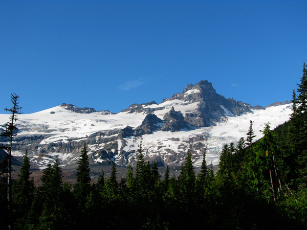
Looking down on the Emmons we were faced with the immensity of the glacier. It stretched for miles with huge crevasses below us. Little Tahoma was not so little from where we stood and Rainier itself (technically, "Tahoma") was a gleaming white monster. The clouds that had been obscuring the summit in the morning were gone and the sun reflected off the snow and ice almost painfully.
Back on snow we followed the footprints and crossed our first snowbrige of the day (over a crevasse) and then shortly after did a little hop over another. Looking down there was no bottom. We didn't linger on the edges even around the tiny cracks. It was a short walk to Camp Schurman around the corner where we stepped off the snow, unclipped, and had a chance to bask in the glory of the mountain.
Freed of crampons, but burdened by a hat, gloves, and a fleece, we wandered around taking pictures and eventually talking with a climbing ranger named Phil. (I think. Why don't I write these things down sooner?) At Camp Muir you feel like you're in the mountains, but here I felt like we were way out there. The summit looked within easy reach and civilization was miles and miles away. Camp Schurman felt like the wilderness even if there were strings of climbers coming down from their summit bids and their footprints clearly marked the snaking route up the mountain.
After about 45 minutes of lounging and watching a big rock fall on the Winthrop Glacier we roped up for the hike out. When (not if) I climb Rainier it'll likely be up this route rather than from Camp Muir.
We jumped the few crevasses and were back on the rock ridge separating the Emmons and Inter glaciers, but this time without crampons. (Woo hoo!) Instead of getting back on the snow we followed the rib down past a couple of ther sites at Camp Curtis and down to the saddle leading up to Mt. Ruth. I suggested dropping my axe. Scott suggested we drop our packs. Scott's smarter than I am.
The only dicey part of approaching Mt. Ruth from this side was a short scramble that was moderately exposed. In regular boots or shoes it wouldn't be a problem. I was concerned the big mountaineering clunkers (that had worked great in the snow) would cause me issues, but in the end caution got us above the block and we were able to traverse to a blocky talus field and to the summit. While the drop to the Inter Glacier looked trivial (why didn't we bring our packs?) the Emmons side was hundreds of feet down if not 1,000. Amazingly, there were a few little flowers among the rocks and we took care not to tread on them. Their life is hard enough.
Pictures, always the pictures, and then back the way we had come. The scramble was again interesting (going down rock is always more "fun" than up), but obviously nothing bad happened. I popped the lens out of my sunglasses and did a bonus crawl to retrieve it before we shouldered our packs and surfed the scree back to the Inter Glacier where we reroped and headed for home.
Below the big crevasse where they were practicing rescue we found the top of a glissade chute. On the way up we'd seen folks sliding down while roped, but we decided that wasn't necessary. Heck, half the people coming up weren't roped. Scott went first, flying over the edge and out of sight. I followed busting past people on the way up.
This was easily my longest glissade at about 1,500 feet of elevation loss in five minutes. Luckily, my bum essentially went numb after the first few hundred feet (I was in shorts, of course) so it was all about staying in control after that. At one point I did get going too fast and rolled over, but I was able to use my axe to right myself and continue on. We wandered the last few hundred feet to the bottom of the snow and onto real ground below.
I was out of water, but got a half liter from another party on their way down. They probably felt they owed it to us since it came from a Nalgene Scott plucked from the glissade route. It was tasty.
I switched back to my normal boots and declared the mountaineering boots to be good, but not good on rock. Perhaps I had them on wrong, but my ankles were a tad tender courtesy of the unforgiving plastic. Walking on a trail in them would not be fun. (Scott had even fancier boots that were a good compromise between regular trail boots and moutaineering boots.)
We made quick work of the trail out, though it felt like it would never end. Day hikers (wait... aren't we dayhikers?) were heading up to Glacier Basin with tiny packs and maybe a bottle of water while we, along with the real climbers, packed monsters on our backs and lots of pointy sharp things like axes and crampons. Back at the parking lot it was a relief to drop packs and change into fresh clothes for the ride home.
The total trip was about 12 miles and 5,300 feet of gain. Although it was cloudy when we got back to the trailhead most of the day was spent under blue skies with little if any wind. It's hard to imagine a better trip on the mountain without standing on top.