(Most of the pictures in this story are bigger and worth clicking "Zoom.")
If I were only five years older... I might have vivid memories of Mt. St. Helens erupting in 1980. But, no. Instead, I remember what my parents have told me about them being one of the last cars allowed to drive over some mountain pass as the ash was falling. My sister and I were staying with... someone (presumably). I remember little bottles full of ash that probably came from a fireplace, but were supposedly directly from the eruption. And, of course, thousands and thousands of trinkets made from "Official Mt. St. Helens Ash!"
The volcano never really played much of a part in my life. There was no fishing nearby so we didn't vacation around there. You can hardly see it from I-5 so on the rare trips we made south it probably didn't make an impression. The only really vibrant memory I have of the mountain was during one of the latest eruption cycles when it and the ensuing web site traffic storm it generated put a crimp in a training trip in Vegas. (It did serve as great fodder for a paper on web site availability, though.)
And then I got old and started working on my bucket list. It is one of the six peaks in Washington designated for climbing before I croak/turn 40. Mt. St. Helens was supposed to be one of the first to tackle because of its low elevation and modest effort. Planning was more difficult, though. The first trip was cancelled due to weather. So was the second. And the third. So this was officially try number four if you don't count half-baked ideas like turning our two-day trip on Mt. Adams into a one-day trip with a try to get leftover permits for Mt. St. Helens the next day.
With time running short Scott and I bailed on the idea of waiting for the "perfect" day and settled on a day that was "good enough" or at least not likely to get us killed.
We left early (expletive early, as I recall) and stopped in Woodland for coffee and food. Then to Cougar to get our permits. Finally to the trailhead. Almost completely free of snow it was an easy drive on paved Forest Service roads. Except that one spot with the HUGE hole that threatened to eat the poor Honda that has seen so much abuse driving me and my gear around while the SUV lives the easy life transporting kids. Hm... maybe the "easy life" is really the Honda who doesn't have to deal with kids as often...
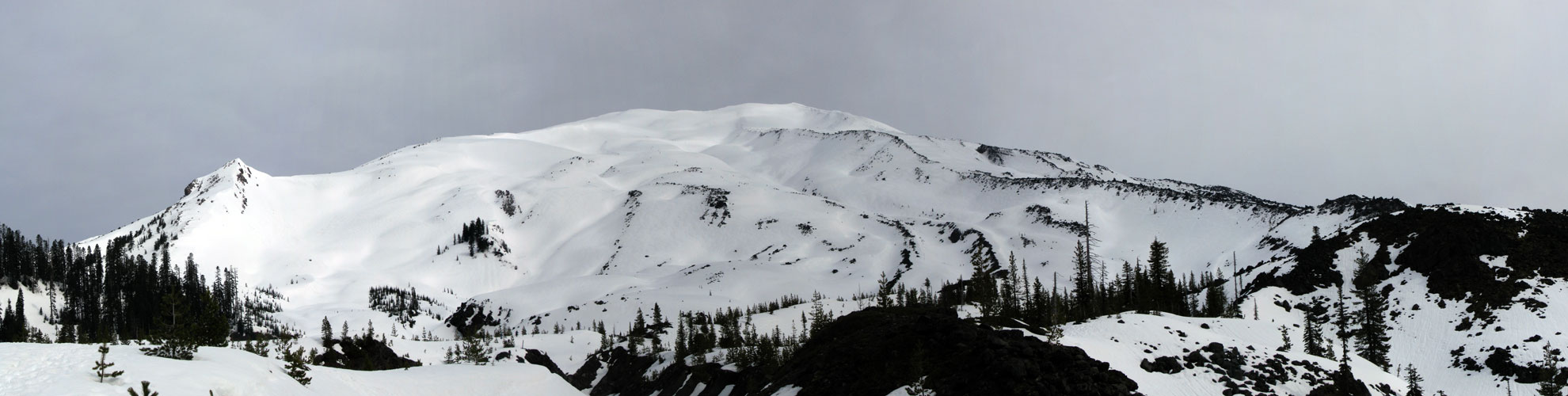
The trailhead was half full of cars. Thanks to the relative lack of snow there were only a few snowmobilers fouling the air and regulations would soon have us parting company. We started up the packed-snow trail through the woods. It twisted and turned through the trees with nary a view. We passed a quarry and made only modest elevation gains before finally getting peaks through the trees of our destination. Against the cloudy white sky it was hard to make out (and harder to take pictures of), but the clouds were supposed to burn off so perhaps shutterdelay was best delayed.
When we finally broke out of the trees completely the low mass of the mountain was before us. Without trees or (many) rocks on the higher slopes it was hard to get an idea of what was ahead. The tiny black dots that hardly moved were climbers already well up the slope. We followed in the footsteps of a few hundred others and made pretty good time. The snow was firm so no need to put on snowshoes (as has been the case lately), but I had a feeling that since I was carrying the new 'shoes I was darn likely to put them on at some point.
From the south the mountain didn't really feel all that much like a shattered volcano. It was just a big flat-topped peak like so many before it. Although climbing in the snow, whether kicking steps ourselves or using previous steps, was far better than climbing in the loose ash and pumice (or so I've been told) it was a slog up. The views changed very slowly. The rim was always way out there and only rarely obscured by a local highpoint. Plod slog plod slog. Up.
The snow changed from well consolidated and slightly wet to a few inches of fluff over a hard base. As we traversed through untouched snow little rollers took off downhill. The sun was shining brightly enough that we needed sunblock, but my hasty application left much to be desired as I would find out later. The final climb to the crowded rim wasn't hard, but the anticipation of looking into the steaming crater made it seem a long time coming.
This was Scott's third summit, but certainly the view couldn't fail to impress. I couldn't look straight down into the summit what with people falling in and not coming out (alive) so instead I looked right at the sheer cliffs dropping down 1,000 feet and to the left at overhanging cornices and over the crater to Mt. Rainier wrapped in clouds and the steam rising from the cracks in the snow in the crater itself. Ooh... steamy.
As much as the idea of a climb up a loose slope sounds lousy I bet I'll be back some time in the not too distant future to see the crater and the rim without all the snow. Blanketed in white it was hard to appreciate the devastation wrought by the eruption. It could have been flowery meadows insulated from the cold for all I know. Of course, a return trip isn't going to take the place of a new destination any time soon (certainly not before the bucket list is done) so it'll be a few years... maybe when the kids are ready. 2015 for the 35th anniversary?
Getting down sounded easy. The initial glissade from the rim was fast, but not as long as we might have hoped. The descent was a series of short glissades and marveling at people heading up through the increasingly sloppy conditions. Who knew getting up so early would pay off so well? (Um... we did. That's why we did it. Duh.)
Unfortunately, the slopes petered out and we were back to walking like chumps. Skiers were easily passing us, but at least the snowboarders had some issues on the flat terrain, too. After a few too many postholes we put on snowshoes and I'm left to hope that in those conditions no snowshoe could have performed better. I'd hoped the fancy new 'shoes would let me walk up walls, but all they did was slide like the old Atlas 'shoes. I'm holding out for better test conditions next season.
The drive from the trailhead back to Woodland was (seemingly) much faster with only a single stop to check out at the climber's register. There are a series of caves in the area that I think would be fun with the kids in a few years. It seemed about an hour off the freeway so it's not trivial, but we could work it into a trip south, I think.
Rather than settling for lousy food we searched through Woodland and found the Eager Beaver drive-in. It was pretty much Scott's Dairy Freeze and that's a good thing. Except no slushies. I hope they work on that.
Total distance: 12 miles and 5,600 feet of gain. And only four more (buckety) mountains to go.