If I asked you what the five volcanos in Washington are my guess is you'd answer me like this:
Mount Saint Helens (correct)
Mount Rainier (correct)
Mount Baker (correct)
Uh� Mount Hood? (wrong: Hood's in Oregon)
Are you sure there are five?
Most people outside of Yakima don't remember Mount Adams even though it's the second highest in the state. And almost no one outside obsessive peak baggers would think of Glacier Peak. You can see it from Seattle, if you know where to look, but because it's in the middle of the Cascades and hard to get to most people don't give it much thought.
(In case you can't tell. I'm not like most people. I'm broken.)
Turns out, Glacier Peak was the last on my bucket list. Since it was at least a three day trip it was hard to schedule. Weather canceled an attempt last year and with this being the last summer before I turned old the pressure began to mount.
Until I determined that if I didn't summit I just couldn't turn 40. Sweet. Either way I win.
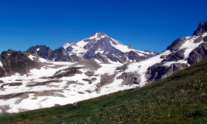
Plan plan plan. Drive drive drive. Start hiking at 9:30pm on Thursday night. We arrived at the Mackinaw Shelter in two hours, threw down tents and bivies, and were asleep by midnight. Up at 5:30 and on trail by 7 for a long day. Up 26 switchbacks to White Pass (yes, I counted), high traverse above the headwaters of the White River, and finally we get a view of our goal.
Holy� That's still a really long way away and it looks pretty high.
And say goodbye to green. "White Pass" was full of lush green with just a few remaining patches of snow. From here, though, it was rock and snow almost exclusively. Now it was starting to feel like an epic trip.
We crossed fields of snow, skirted the dying White Chuck glacier, hopped over sole-sucking (see what I did there?) quicksand, and scrambled up loose piles of rock. By early afternoon we were at Glacier Gap, our base camp.
And it was hot. Real hot. The others crawled into tents to escape the sun. But me? I was so smart I saved a few ounces thanks to taking just a bivy sack. But a bivy sack wasn't going to do anything for me in the hot sun except cook me. So instead of getting in, I cobbled together sleeping bags and rocks and rope and anything I could to create a sun shelter. Darn sun kept moving and so did I. I got little sleep, but at least the sun charged my phone. (Adventure Nerd! That's me.)
We (me, Scott, JK, and Matt) had met up with the other team (Chris, Steve, and Nico) at Glacier Gap. They had been a few hours ahead of us all day. Turns out we had both been at Mackinaw the night before, but they were asleep when we arrived and departed while we were still snoozing. We briefly debated pushing for the summit that afternoon, but decided the snow would be too soft. Plus, we had until Sunday to get home so no rush.
The rest of the day was spent lounging around, avoiding the sun, and, because I clearly hadn't done enough climbing during the day, climbing a couple hundred feet to a little peak just south of camp. Sunset was glorious, but we were on the wrong side of the mountain to get much in terms of alpenglow. Bummer.
At 3am we woke for the climb. With seven of us, you can imagine there were no shortage of leaders so we made a few detours in the dark looking for the best way to get on the glacier. Finally roped up, we started the slow, careful climb. From camp, we could see a section of brutally crevassed ice just to climber's right of Disappointment Peak. We'd figured we'd have to stay close to the peak to get around it because there was no way we were crossing it.
Oh, how naive we were back at camp. We weren't going around the broken ice. We were going across it.
Thankfully, there was a "safe" crossing well trod that weaved through the cracks in the ice. We didn't linger. Above, we crossed the rest of the Cool Glacier until we were back on dirt and rock. The final 800 feet were up a sandy ridge and through a bowling alley of loose rocks that seemed delicately balanced so just the merest disturbance would send them cascading down.
So close to the summit, the fever took hold. Up until this point I kept the possibility we wouldn't make it near the front of my mind. With only 100 feet to go, I let the reality of a five year plan coming to fruition to consume me, filling my legs with adrenaline. Scott, the only member of the team that had been with me for all five of the volcanos lamented that I'd get my fifth and final before he would. Given I normally trail him, it was sweet indeed.
Views from the summit were awesome, as expected. The official NOAA forecast had called for a possible storm, but Matt, a recovering weatherman, had given us a custom forecast that said we were good through Saturday night at least. In Matt, I shall trust. (Take that Renner!)
Pictures and high fives and it was time to descend. The bowling alley was pretty gnarly, but only one person was still on his way up and well off to the side. We stayed together to minimize having to drag a body down to camp. The snow was starting to soften and the teams still climbing the glacier were having a harder time than we did. It was a great validation of our decision to get an alpinish start rather than an afternoon attempt.
Back at camp, we retreated to our shelters for some rest. The other team took off in hopes of getting back to Mackinaw before the end of the day. We had a more modest destination of White Pass so we didn't leave until much later.
There were sections of uphill on the way back, but nothing too bad. We were at White Pass with plenty of time before dark to enjoy the bugs that weren't present anywhere else. Clouds were gathering on the horizon, but Matt gave them only a small chance of delivering any rain. I had the luxury of cached Cokes along the trail. Four of them, in fact. On the way up I heard heard this song in my head.
48 ounces of Coke in my bag. 48 ounces of Coke. Cache one here, it's better than beer, 36 ounces of Coke.
In the morning, the clouds pushed up the North Fork of the Sauk valley below us, but then retreated. Just as Matt said they would. We promoted him from weatherboy to weatherman. He earned it.
The last 10 miles to the car was long, dusty, and not much fun. It hadn't been fun on the way in, but the excitement of the climb ahead made it tolerable. I tried to count switchbacks, but came up with only 19. Apparently, I'm bad at math. I did clean out any remaining berries, though.
Finally at the car, we refreshed in the river and then returned to civilization. I felt older already, but accomplished. And already planning my next bucket list. All the volcanos in Washington? Pah! No challenge. How about all the volcanos in the Cascades? (Good thing I'm giving myself 10 years for this list.)