A well known Snoqualmie Pass peak that hasn't suffered my footsteps? Really? Actually, there are a bundle of them, but few are as easily approached as Red Mountain and even fewer are regulars on the TNAB schedule. So imagine my displeasure when forced to choose between TNAB to a new destination and the first night of the Pine Lake Park concert season. Throw in near perfect weather (for either event) and you can see me struggling to decide.
On the one hand is a new (to me) tower of rock promising a snowy approach through the Commonwealth Basin and a scramble on loose rock that is best done with noggin protection. Hard to resist, huh?
On the other hand it's the first night of the girls' favorite summer activity. They dance and twirl and we all eat ice cream bites while enjoying the tunes. Equally attractive.
Why oh why couldn't it have been WNAB or even TNAB, but on Tuesdays? (Have you forgotten what TNAB stands for? It's the Thursday Night After Burners. Does the WNAB thing make more sense now or are you still thinking about women's basketball?)
In the end Nana and Papa were going to be at the concert and it's a two month season. TNAB was likely to begin repeating summits I've already tagged or don't hold a ton of interest for me so hiking won out. Barely. (In fact, I had already changed my status on Facebook when Amy convinced me it really would be ok to abandon the family.)
As usual, it was a mad scramble to get out of the house early enough to meet the crew at the trailhead, but this time it was a little easier since Amy and the kids were also packing and they left a little before I did. (Although I'm officially a bus chump now I drove so I'd be able to get home in time for the hike. The bus is lovely and all that (can you detect the sarcasm?), but it takes an extra half an hour to get home.)
At the trailhead were many of the usual TNAB folks. We started quickly up to the upper PCT trailhead and after only a little confusion were back on trail. (Um... don't you guys do this every year?) Although I've been up the Commonwealth Basin numerous times (2001, 2006, 2007) it was always in winter. In fact, I'd been up to Red Pass on snowshoes, but not to the summit itself.
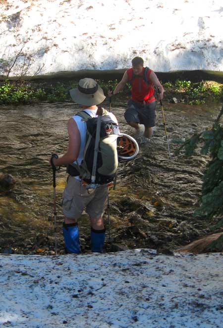
Even though it's the middle of July the basin is still thick with snow. Perhaps three or four feet of it. There's a barely discernable track across the hard snow roughly following Commonwealth Creek gaining almost no elevation as it weaves between big trees and across semi-frozen swamps and over small creeks swollen with melt.
We had to cross Commonwealth Creek, but couldn't find a suitable place. Although there were none of the 10-foot high snowbanks to descend the water looked awfully cold. The bulk of us decided to trust in the mighty Gore-Tex and our gaiters and ran across the creek. Even though I could feel the pressure on my calves I remained dry. Poor Kirk, without gaiters, took his boots and socks off and walked across. He let us know that one's toes go numb very quickly in nearly frozen water. (Chris, ever the rebel, found a log across the creek. Cheater.)
Geared up again we pushed further up the valley to the next crossing. We found a couple of logs in a jam that seemed like a crossing, but it wasn't attractive enough to abandon our search. (Except Chris, again, who leaped across without regard to the risk. You might recall that it was Chris who fell into the Pratt when he and I set off to climb Russian Butte.) In time we realized that was our best bet and returned to cross there. It turned out to not be as bad as we had thought, but nobody was looking forward to finding and crossing it again in the dark.
After crossing yet another creek on a dodgy, rotting log we were finally to the beginning of the real climb. Somewhere there was a trail with bundles of switchbacks. It's the old Cascade Crest trail that was replaced by the PCT, but is still in great shape. Unfortunately, we weren't anywhere near it as far as we could tell so we did what any good TNAB team would do. Go straight up until something got in our way. Then we turned.
As we crested the spur that headed up to the ridge we were relieved to find the trail. Although the basin was still snowed in the upper stretches that had received some of the sun of early summer had melted out so we kicked into gear and made great time to the tarns at Red Pass, though they were still almost completely frozen. Now came the fun part and out came my helmet. (And this time I wasn't alone. Rich brought his helmet, too.)
On the loose rock there's a sort of trail, but it's a little hard to find and once found is fairly hard to follow. Once again it was straight up until you couldn't go any more. I had Tokul with me so I let her direct our route. She doesn't really dig scrambling and rocks, but did pretty well. The rest of the crew (renamed TNAB: Trundle Not, Amigos Below) also avoided knocking any big rocks loose, though there were the inevitable calls of "ROCK!" as we climbed higher.
At the summit we had an amazing set of views that extended down into the Middle Fork valley and back to the South Fork valley (aka I-90). It'd been hot work to get to the top, but once there we cooled quickly and it got chilly. Pictures, drinks, food, and it was time to head down. We had much better luck finding the trail down the scramble and even Tokul looked to be enjoying herself, though she was clearly relieved when we were back on the snow at the tarns.
For some reason a group of the hikers decided they'd run down the switchbacks, but I abstained. (I only run when chased.) We agreed to meet up at the bottom of the switchbacks so we could head out together in the dark. Tokul took off with the faster hikers (of course) and when I got to the bottom I found that two of them, with Tokul in tow, had headed back early.
We had come in by the Commonwealth Trail, but in the dark the PCT, though longer and with a bit of additional gain, seemed a better choice than crossing creeks and navigating postholes by headlamp. I found myself zoning out on the hike back. It was late, getting up at 4:30 was taking a toll on me, and the PCT just isn't that interesting so close to Snoqualmie Pass especially in the dark.
Tokul came over to say, "Hi," when we returned to the parking lot and we were quickly on our way home to a quiet and sleeping house.
Total distance was 7.5 miles with 2,800 feet of gain and another peak scratched from the to-do list.