I had been trying to get Dan out for a nightshoe, but he had a date with his wife. (A date? What's that? Oh... yeah... busted again.) He did suggest that he would be available in the morning, though. I just needed to be home by nap time.
A little after 7am we left the house with Tokul and Juneau in the back. Our destination was Cave Ridge. It's a high point between Guye Peak and Snoqualmie Mountain. When you look at the three peaks Guye Peak stands up just north of Snoqualmie Pass against the backdrop of Snoqualmie Mountain. It's hard to tell, but Cave Ridge is actually about 100 feet higher than Guye Peak, if not as dramatic.
We started up the Commonwealth Basin along the Pacific Crest Trail. Last time it was dark, but for this trip the sun was blazing even though it was only 28F.
We booted up to the PCT trailhead with snowshoes in hand and stopped before getting on the trail proper. However, the snow was firm enough that we strapped the snowshoes on our backs rather than on our shoes and headed north.
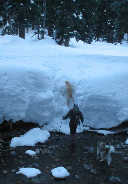
The trail passed quickly and in no time we were at the creek crossing. I had figured that each year the crossing point would shift up and down the creek, but it was in the same spot as the previous year. Without snowshoes it was easy to climb down the steps that had been cut into the bank. The trick to crossing the creek was to step on rocks an inch or so below the water. The exposed rocks were coated in an invisible ice and uber treacherous. Only the dogs had a problem getting out of the creek.
As we started down the trail again a party of three skiers stopped at the crossing. They were headed for Snoqualmie Mountain, but hadn't been there before. They opted not to cross and continued on the east side of the creek. We didn't see them again, though I had hoped they might lead the way to Snoqualmie Mountain.
We followed an established trench along a ridge heading mostly north. I was looking for a creek valley heading up to the saddle between Guye Peak and Cave Ridge, but we must have missed it. We wound up at a saddle between the shoulder of Cave Ridge and the ridge we were on. We side hilled a bit, but wound up dropping down to skirt the bottom end of a small avalanche slope.
(Now's a good time to point out that the danger level was "low" with special attention required on south facing slopes in the afternoon.)
We crossed one at a time with no problem and started up the ridge in the trees. The snow was still hard enough to kick steps with no postholing. The dogs had the easiest time and made good time up the steep slope while Dan and I labored under the weight of our extra gear. At about 4,500 feet we started punching through the snow and put on snowshoes.
We found a set of tracks heading around the east end of Cave Ridge, but they crossed another short avalanche slope. We looked straight up, but cliffs prevented that route. With a little creative navigation we stuck to the trees and had only one exposed crossing with a safe run-out if something unlikely happened. Once in the trees on the other side we had no problem getting to the more moderate slopes above.
The snow had an icy crust so every step sent little chunks of ice skittering across the snow. We passed what I think were a couple of little ponds, according to the maps. It was a little hard to tell exactly which summit was the true summit, but we settled on one with great views and dumped our bags.
Tokul and Juneau spent their time running back and forth between whoever had more food exposed. While taking pictures and drinking in the views I realized that we weren't actually on the summit. I pointed this out to Dan who seemed unconcerned. He was content, but I decided it was worth a few minutes to tag it and see what there was to be seen.
I headed off with Tokul in tow. It took just a few minutes to get there. The views were only marginally better and almost exclusively Snoqualmie Mountain, which dominated the view north. I had left my camera on my bag (dang) and Dan made the most of the opportunity with a few too many arm-length shots.
When I arrived back at the bags we packed up and started down. Rather than retrace our steps we followed the established trail down the west side of Cave Ridge. It was a far more moderate descent than if we had gone down the east side and was much closer to the route I had mapped out at home.
The trip down was, as usual, quick. I was on the lookout for where we had missed the turn, but never saw it. Back in the basin we put the snowshoes back on our packs. We could hear Commonwealth Creek, but never got back to the crossing we had used earlier. It became clear the tracks we were following were not at all connected with our route up or the PCT on the other side of the creek, but clearly they must have come from somewhere.
The trail wound us up at the Sahale Ski Club, which is a private ski area of sorts. It has a tow rope, though it wasn't running and the place was deserted except the three guys who made it clear we weren't welcome walking across their property. Hmph.
I got home as the kids were finishing lunch and in plenty of time to help get them settled for naps so overall it was a really successful trip.
Total distance was 5.80 miles with 2,330 feet of gain. Car to car was about four hours.