The evening hiking season is growing short. Sunset was at 7:37pm, which meant that almost anywhere we went, even with a good pace, coming down would be in the complete darkness. Ah, but the destination was one that's been on my list for a long time so at 5:20pm I kissed the girls goodnight, got Tokul in the front seat of the 'onda, and we were off.
Rampart Ridge is above an area I've been a lot lately. I've been to Rampart Lakes twice (October 2005, August 2006) and Lake Lillian a bunch (1, 2, 3, 4). However, the high point of Rampart Ridge at 5,870 feet had always been a "wouldn't it be nice to got there? too bad there's no time," kind of spot.
I got to the trailhead by about 6pm and saw two cars. One was familiar since it belonged to one of the other TNAB regulars, but the other was unknown. I got boots on and Tokul and I set off down the trail... er... up. The trail to Lake Lillian is a steep trail gaining about 1,000 feet in a mile. Some sections are especially steep since a huge tree caused an organic reroute of the trail over the winter.
Before we even really started up I looked up and saw a sweaty hiker waiting for me to pass. I popped an earbud out of my ear and apologized for not realizing he was there. "Oh, that explains it," he said (or something like that) as The Crystal Method was still ringing in my head. The climb to Lake Lillian was uneventful except that I set a new world's record for people with my name. 18 minutes to the Lake Laura trail and nine minutes more to Lake Lillian for a total of 27 minutes. Yee ha.
Tokul dove into the water and I rinsed the sweat from my face before we continued on. As usual, Tokul had some issues crossing the rock at the southeast end of the lake. There's supposed to be a way around and over the rock, but I've always been too lazy to look for it seriously.
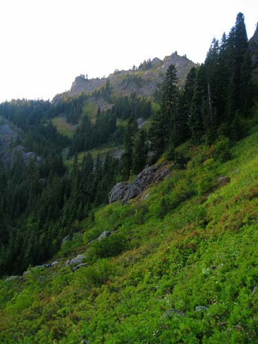
We climbed up the gully to the saddle on the ridge above. On the way we passed through patches of tasty blueberries, but where we needed them most, in the dusty gully, they were dried up. So sad.
There's a trail junction with one trail traversing across the slopes toward the Rampart Lakes and another, less traveled trail that climbs steeply. I'd been a little way up the hill the last time I'd been out this way and I knew the trail continued beyond where I stopped so that's the way I headed.
Looking down on Lake Lillian was cool, as always, but with the sun dropping toward the horizon I didn't spend much time. (I did gaze at Lilly's namesake lake long enough to see a string of TNAB hikers making their way along the shore.) The trail faded away at one mini peak after another, but always reappeared after a short search. We followed the line of the ridge around to the northwest until we were looking down on Gold Lake about 800 feet below us.
Around here I realized we weren't following the official TNAB route. There was no way even the wacky TNAB troops would be up for heading this way in the dark. Still, it wasn't too hard to make good progress. Had I continued running the ridge I would have wound up at the destination, but I saw a trail in the valley below and decided it'd be safest and best if we dropped down. It wouldn't do to wind up on the wrong side of a little gully forcing us to go back and then down.
From a saddle I could hear someone above and looked up to see TNAB vets Larry and Dan silhouetted on the peak. Tokul and I were soon at the base of a big pile of rock that looked really unlikely for Tokul. I tried a way around, but she balked at even the "easy" approach so I tied her to a branch and hoisted myself to the top. It was about one hour and 34 minutes since I left the car.
Below us to the west was Gold Creek and Gold Creek Pond where we snowshoed last season with the girls and with Gregg. To the north were the Rampart Lakes and Alta Mountain (among other peaks). The whole area was full of rock and brush that was just dreamy.
The rest of the hikers, 11 in all, trickled in. Soon the summit was crowded, but I'd taken most of my pictures earlier... except the nearly full moon rising through the smoke of the Polallie Fire near Cle Elum. Wow.
When it came down to head down it was already pretty dark. Tokul and I were near the middle of the pack, but I drifted toward the back taking pictures and picking blueberries for the girls. (I always feel bad and guilty when I'm hiking without them.)
The route down stayed off the ridgeline and followed a trail past a series of tarns (some dry) until it intersected the Rampart Lakes trail. The gully down to Lake Lillian was fairly treacherous. I could see lights strung out down the 400 foot drop fuzzed by the fine dust kicked up.
After pushing and pulling Tokul across the rock on the shore of Lake Lillian we started down the trail to the cars. At a junction the hiker in front of me waited to make sure I made the right turn. I waited for the folks behind me. Sensible and polite. That's what TNAB is all about. (Um... yeah.)
At the cars we counted and came up three short. Oops. We tried cell phones, but about half the hikers' phones didn't have reception and there was no guarantee any of the overdue folks had theirs on. Did they have GPS? Well, maybe, but why would they look at it on an established trail? Headlamps? Maybe.
Wouldn't they notice they were going the wrong way? Yes, definitely.
Half an hour later, just as we were about to send someone to the end of the trail we figured they were on, the hikers stealthily emerged from the trail. They had indeed missed the turn at the fork and were on their way out the official trail. (In fact, that's the same thing that happened to me and Dan when we first hiked to Lake Lillian years ago except we were trying to go back along the official trail and we wound up coming down the unofficial trail.) They realized they were in the wrong place when they crossed a new talus field and the trail started going uphill.
Their exta bit of time on the trail meant we got to the North Bend Bar and Grill just after they closed the kitchen. However, the waitress recommended we take our big bill over to the Porterhouse a couple of blocks away. I was skeptical since I didn't remember another restaurant or bar so close, but followed anyway. When the lead car pulled over next to the Shanty Tavern I was ready to drive home, but then we saw the Pour House (its real name) and pulled over there. The atmosphere was more energetic than the NBBG and the food at least as good. We'll probably be back.
The total trip was just over four miles with 2,300 feet of gain. The only regret I had was that it was dark by the time I got there so I didn't get a chance to really see how great a spot it was. Needless to say, I'll be back there.