Dan and I had made a trip to Lake Lillian in November 2002, but we took the official trail over Mt. Margaret, past Twin Lakes, and finally descending to Lillian. I'd always heard there's a "secret" route up to Lake Lillian that doesn't waste any time with gentle grades, but does pass by several big waterfalls so when Nick and I were looking for a trip we picked this.
I had to do a bunch of digging online (and some begging of more in-the-know hikers) to figure out the route, but when Nick arrived at the house at 8:15 I had it in the GPS and on paper. We drove east over Snoqualmie Pass and then... (you didn't really think I'd reveal a "secret" route here, did you? If you think you deserve it drop me an email.)
We had to park the car about a mile short of the unofficial trailhead due to snow. Somebody in a big truck had continued, but Nick didn't have faith his little Subaru would clear the snow so we donned snowshoes and started up on foot.
The snow was awful. Kind of like walking in a great big snow cone. At the "trailhead" we realized we had little chance of finding the trail so we just forged ahead. We knew we had to follow the creek up to the lakes, but whether we should be on the west side or the east wasn't clear. We chose the east side and worked up through a clearcut.
We crossed a cascading torrent of water that we originally thought was the main creek, but turned out to be the outlet from Twin Lakes. Dang. From there we continued pushing up the hill until we heard a waterfall off to the left. The falls was one of several we expected to see and was marvelous. It was a short falls that became a cascade.
Since we clearly couldn't follow the creek up over the waterfall we looked at the wall on each side and chose to stay to the east. We found a notch in the wall and climbed up to it. Nick got to a spot that was dicey to say the least. From his vantage point he could see that there was an easier approach if I crossed below and came up from the other side. That worked for me, but Nick had to take off his snowshoes and flip them up to climb up the rocks.
Once Nick had re-shoed we started through the meadow and soon came to another waterfall. This one was a simple curtain of water and much higher. After checking it out we looked for a way over the wall that separated us from Lake Laura. No notches, no easy climbs, nothing. However, looking a ways to the east we could see it looked like if we traversed across the base we could go around. Unlike most of our other navigational decisions, this one panned out and we had a relatively easy climb.
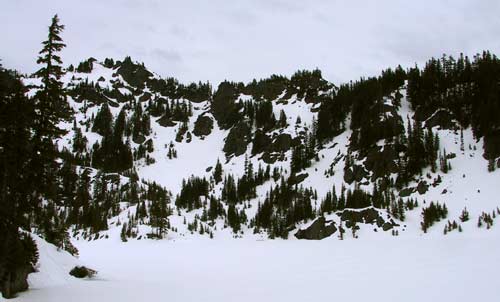
We took a quick glimpse at Lake Laura, but it was a ways below us by now so we chose to save it for another day and continue up. We had about 300 vertical feet to climb, but had to circle way around Laura's bowl to the east due to some very impressive looking cliffs. The snow was very slippery in this section, especially where it was in the open, so we made very slow progress. Eventually we crested the ridge and were on the shores of Lake Lillian. (This is right about the same spot the official trail gets to the lake.)
There was about four feet of snow at the lake, but it was melting fast. We could see just the touch of blue around the edge of the lake signifying the ice would be giving up soon. The scramble around the highpoint that separates where we were lunching and the outlet was covered in snow so we chose to leave that for next time.
The way back down was more of the same. The snow was lousy, but worth a shot for glissading since it was so steep. I had my avalanche shovel/sled so I tried that, but couldn't really get going until the snow I was sitting on broke free and started down with me. More snow piled up between my legs, which shouldn't have been a problem as I should have been wearing pants, but I had on only shorts and gaiters. Ugh.
The only other excitement was when I lost my footing and began a 15 foot uncontrolled slide in the trees. I was sliding on my right side (meaning I wasn't interested in using my still-recovering shoulder to arrest the slide) and picked up speed before heading for the ledge. I slipped off the edge and fell... two feet. It certainly seemed a lot farther down when I was in the air even if I never really left the ground.
In the end we saw four or five waterfalls (it depends on whether one of the run-off streams could be classified as a waterfall) and gained about 1,500 feet. The actual hike was only about two miles each way, but it felt much more than that.
I got back to my house just in time to get everything cleaned up, get a shower, start laundry, and head to the in-laws where Amy and the bugs were holding court. Hurray for a short, but intense climb. I can't wait to do it again when there's no snow.