On August 7 a well-respected hiker died in a climbing accident. The news sent shock waves through the members of the hiking community. On August 13 fourteen people climbed Big Snow Mountain to place the Ed Miller�s Traveling Summit Register Memorial at the summit.
A week later I convinced Dan that we ought to go up and get it to keep it on the move. After all, it's a "traveling" register so it shouldn't sit anywhere for too long. Amy got home from her morning walk Sunday morning at about 9am and after moving the carseats into Dan's Subaru (so Amy could take the kids to NanaPapa's) Dan and I set off out the Middle Fork road to the trailhead.
The first 10 miles or so are on county and Forest Service roads. Pretty good. 30 minutes to the Taylor River. The next seven or so miles is passable on Forest Service roads and took about 30 minutes. The last six or seven miles are on a Forest Service road that is scheduled to be decommissioned as early as this Fall. The road is notorious and took an solid hour.
Of course, that might have been because we stopped to pick up chicks. For much of the last section of the road we were following a newish Subaru wagon. At about a half mile from the trailhead we found the two women in the car getting their gear ready. We asked where they were going (since there was no obvious trailhead where they parked) and they admitted they weren't up for driving any further.
Since they were looking at a long hike up the Dutch Miller trail and another mile on the road wouldn't help them out much I offered them a ride and they accepted. (The Dutch Miller trail was the site of two day hike with Nick in 2004.)
Once we found our trail (an unofficial scratch disappearing into the trees) we parked and told our new friends they'd be walking from here. We probably saved them half a mile on the way out. They still hoped to get to Williams Lake (about seven miles up the trail) even with the late start of 11am.
There was one other car where we parked (another Subaru, are these things free or something?), but none of the crowds I had expected on a day as nearly perfect as it was. Blue skies, not too hot, just about perfect.
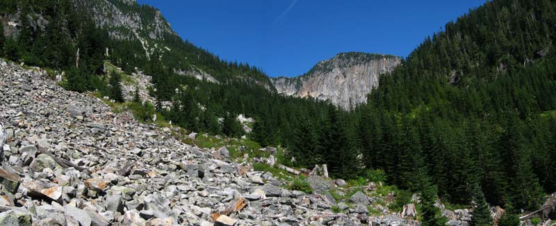
We started up the trail through the second/third growth forest and the trail quickly gained elevation. The trail gains about 1,400 feet in the first mile and a half before arriving at Lower Hardscrabble Lake at the base of Big Snow Mountain. Well before we arrived at the lake we could see the mountain looming above. As we climbed the forest became more mature. We crossed a talus field marked with cairns almost every 10 feet to ensure we didn't lose the route across the rocks. On the other side of the talus we started finding blueberries. Mmm... tasty.
At the lower lake we followed the western shore across talus (sensing a pattern yet?) and finally across a meadow/swamp at the north end of the lake. A group was packing up after a night or two at the inlet, which was clearly the choice spot to camp at the lake. I asked if they had gone to the summit, but they said they were only at the upper lake. The trail was hard to find (info I had heard from others, too), but it was marked with a ribbon. If you get to the waterfall you've gone to far.
So after passing a marmot who gave us the evil eye (and caused the auto focus on the camera to freak out) we stood at the waterfall looking for a ribbon. Oh, yeah. There it is. On the south side of the creek from the upper lake. Still, I couldn't really find a trail. Two other hikers were also looking around for the trail without much luck so I started up what might have been a trail only to have it peter out. I circled around and tried again and got a ways up before getting Dan to follow. Then the others found the trail on the other side of the creek. Dang. We climbed through the brush to a flat spot in the creek and crossed there and were back on the trail.
It was under a mile and we were at the upper lake. The upper lake wasn't much compared to the lower lake. It was smaller and its views were more closed in. The couple were there and we talked a bit. Nate and Lauren (probably wrong) were from Seattle and Woodinville.
Oh, where in Woodinville? Just on Bear Creek. Really? I grew up near there and my father still lives there. No way! Way!
She lives literally next door to my ancestral home. Freaky. They were snacking so we headed off with the expectation that they'd catch us pretty quickly.
In fact they did. As we rounded the lake and the trail faded away they caught up with us. I found another trail heading in the right general direction from the inlet to the lake so we followed that into the meadow due north of the lake. Lots of blueberries, but no obvious route up and the GPS showed we were off track.
Being off track here wasn't a big deal, though. There was only one really feasible way up and it was up to us to pick our way through a monster talus field gaining 1,000 feet in under a mile. Our new friends made quick time and disappeared around a corner while Dan and I made slower progress. It took an hour to get to the saddle. The views behind us were good, but nothing compared to the views to the north when we crested the ridge.
From where I sat to eat my sandwich I could see Gold Lake in the foreground and in the far north Glacier Peak. In between were hints of lakes and peaks too numerous to name. Dan arrived a little after I did and sat to eat while I studied our route to determine where we had to go next.
From where we sat, at the saddle between points 6131 and 6006 it was another mile and 900 feet of gain to the summit of Big Snow. In between were snow fields, granite slabs, and a jumbled landscape of rocks. Almost nothing green could be seen outside the narrow cracks filled with tickles of snow melt. Patches of brilliant green moss jumped out from behind the rocks. The water was crystal clear and ice cold.
The big feature was a nearly flat, huge slab of granite criss-crossed with cracks and littered with football-sized rocks. Perhaps that's why it was dubbed the "football field." We crossed and started into the rougher landscape leading higher.
Dan decided he had had enough and made a temporary camp while I continued on. Normally, I wouldn't keep going by myself when I knew there was some scrambling ahead, but the other two hikers showed up again. Their dog had slowed them tremendously on the talus and we had passed them all the while believing they were way ahead of us. Off the talus they blew by me, but I felt more secure knowing they were around if I needed help.
We crossed another snow field and a smooth granite ramp that seemed to lead to the sky. The final scramble to the summit was steep, but otherwise not challenging. The others were already sitting near the summit and discussing the names of peaks on the horizon. I had printed a labeled panorama and shared it with them. (The pano wound up in the summit register for others to use.)
I signed the normal register and opened the memorial register. A film canister of Ed's ashes shared space with a notebook and one of his pictures. (He was well known for his amazing photos.) The notebook was full of heartfelt notes. I added a regret that I never really knew Ed and packed the register into my bag.
The hike back to Dan was uneventful. I looked for a tarn that I had seen in photos, but couldn't find it. (I'm pretty sure it was below and to the north a bit.) I got back to Dan and we found a spot with running water to fill up our resevoirs. While I filtered the others came past and chided me for filtering. After all, I'd been eating the snow that was melting to make this water for the last hour after finishing the last of the three liters I had brought from home.
The way down was generally uneventful. Descending talus is never fun and a thousand feet of it was really not fun. As we hiked from the upper lake to the lower the sun set over the summit ridge. At the base of the waterfall I found the trail we came down on was indeed marked with a ribbon. Lesson to those who go this way, stay to the north of the creek by the waterfall.
Back at the truck we said goodbye to Nate and Lauren who also raved about the trip. I threw my camelbak into the back seat so I could continue to drink on the two hour drive out (I would consume a full six liters of water) and found a set of keys about to slide into the seat. As we passed our morning's passengers' car I hung the keys on an extended wiper for them to find when they returned.
The climb took four and a half hours from the car to the summit. (An hour to the lower lake, an hour to circle the lower and climb to the upper, an hour up the talus, and an hour and a half from the saddle to the summit.) It was only two and three quarters of an hour to get down.
The total distance was just over nine miles (courtesy of our repeated detours off the usual route) and about 4,000 feet of gain.
We got back to the house at about 9pm. It didn't seem right to put the register and Ed's remains in the garage so I put it just outside the fence where it was near the river. (A day later I moved it to the tip of our island with a better view upstream.) It'll stay there until it makes another trip to a summit some time soon.