|
|
|
Granite Mountain and more
posted by John : August 11, 2010
prev
zoom
next
For detail work only
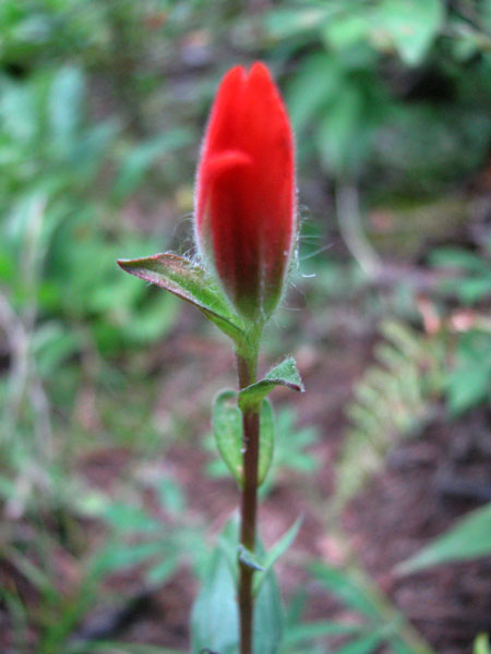
Indian Paintbrush was just coming out to play.
I had another day of bachelorhood and although I'm sure I should have sat on the couch and watched inappropriate movies I conned Eric into heading back into the woods. After the previous night on Mt. Washington we were both keen to take it a little slower. Something relaxing. You know, like Granite Mountain.
Except not Granite Mountain. We'd go most of the way up, then go cross country to see if Denny Lake would be a good camp spot for Eric and his daughter.
Here's Eric's brief, but accurate description of the trip:
It went quick up, slower up, "Arggg, burrito, bad", really slow up, "Mmm, berries", then schwack up, up, then schwack down, down, "Ooo, pretty", more down, then schwack over, over, then "%*#@&%$!", then schwack up, up, up, "Ohhh, so that's the gully, dang it", then scramble up, "East Granite!", pic, pic, scramble down, over, up, up, up, "Lookout!", pic, pic, M&Ms, pic, pic, then headlamps and down, down, down, and down.
I'm not one for brevity, so...
It was hot and muggy down low. Then there were a couple of not-quite-ripe huckleberries. When we got to the meadows we'd find a bush here and there that was fully ripe with sweet, tangy fruit. Oh, glorious huckleberries, why must you be limited to only a one month span of time?
At the far east end of the long traverse just entering the meadows we left the trail for the ridgeline. It looked so easy and in the grand scheme of things wasn't really that hard. However, after Mt. Washington the day before and the 2,000 feet we'd already climbed it was occasionally a challenge to remember to step carefully.
At the top of the ridgeline we realized it wasn't a well defined ridgeline. That meant we couldn't just look down and see where we needed to go. It was very pretty, but the trees and brush were a little thicker. Really pretty, but thicker. We stayed to the more open areas following game trails and phantom trails here and there. Human or deer? Feet or run-off? Beats me. We dropped a ways and decided we'd dropped to far, though we were still above the elevation of the lake. We climbed a bit while continuing north(ish), but soon realized it was getting too late to continue while we were making so little progress. Our exit was up to the ridge to see what we could see.
The ridge top was beautiful with clear views in almost every direction. There was a fire ring (boo!) and a little bootpath leading along the ridge to a high point (East Granite?). Naturally, we went that way. Along the way we saw a huge gully that led directly to the lake. Clearly, this was the gully that had been mentioned in reports. Next time...
On East Granite we looked around, slapped some mosquitoes, and decided a quick summit of Granite was in order. I'd missed the TNAB visit to Granite to conserve energy for slightly more ambitious destination so I was happy to get there again. No snow this late in the year, though, so we'd take the trail through the basin.
We side-hilled down to the trail (clearly the best way to attain East Granite) and then my legs threatened rebellion when asked to start back up the final stretch to the summit. My usual route (with snow) is along the rocks on the south ridgeline, descending into the basin only when glissades are available. Although there was some snow left it was just a tiny patch and I left it for some other weary soul to sit in it. The last bit seems like you're miles away from the lookout (while it's out of sight) and then you turn a corner and you're there.
I snapped a few photos (of course), ate some M&Ms (duh), and dug out my headlamp for the trip down. Eric had professed his lack of confidence in getting to the top in a reasonable time, but he was right behind me. The way down was pretty much just like Eric wrote, "Down, down, down, and down." Nothing more to add to that.
We skipped any after-hike treats at the Pour House (or anywhere else) because I had to be up early.
Total distance including the up and down and around and schwacking and cursing and final retreat: 8.3 miles and 4,100 feet.
|
|
|


