Was it a good choice or divine punishment?
This was supposed to be my annual backpack trip with Clara, but we pushed it by a week. There were lots of other reasons, but it's hard to point at those when I got the chance to go on a climb of Kaleetan Peak by risking Clara's trip by delaying it to the last weekend in September. (Of course, I'd point to the fact that we had delayed until the second-to-last weekend of September because of the whole 3day thing.)
And why was I so keen to climb Kaleetan? Well... hard to say. It's the second highest peak in the Snoqualmie Pass area, but I've already climbed Snoqualmie Mountain that beats it by a few feet. It's got a nice mix of official trail and climbers tread and scramble through forest and meadow and rock. Really, though, it was one of the few long, ambitious trips of the season with some of the TNAB folks that wasn't confined to just a couple hours of daylight.
When we made the call it was looking pretty nice for Saturday. By Friday the forecast was for cold, clouds, fog, rain, and other really nasty things when climbing up high. No surprise. The last time this group tried for Kaleetan they were forced to cancel due to a lightening storm.
When the dog got up at 4am it was pouring rain. When I got up at 6am it was merely misting. I checked email since teh Interwebs rule our lives and saw that at 1am Josie has sent an invite to carpool. Ok, looks like we are still on. At 7:10 I was at Trucktown waiting... and waiting... and waiting.
I called, but went straight to voicemail. Hm... maybe this isn't going to happen after all. At 7:20 I left a message and drove to the trailhead. Nobody there but a couple of boyscouts looking none too pleased at the idea of going into the woods. Well, crap. What to do now?
Sweet! The phone's ringing. Apologies were profuse and when they arrived I said hi to the three from TNAB (Josie, Scott, and Joseph) and met Todd and Tom. (Nope, no dogs. Sorry, puppies.)
Finally ready we started up the easy Denny Creek trail at usual TNAB pace. Of course, it was Saturday so we slowed after a bit. Quickly enough, though, we were at Hemlock Pass. This was where we departed the trail for Bryant Peak. This time we continued to Melakwa Lake. Last time I was there it was much better weather and the I remembered the lake as huge. It was, however, actually pretty small. I think.
We couldn't see anything beyond the rocks on the shore. So instead we looked at maps and I pondered Melakwa Lake as a destination for a kid overnight, but dismissed it since it'd probably be too crowded.
After some fairly awkward moments involving a pepper we shouldered our packs and started up the unofficial trail, past the lavy, and climbed toward our first peak. The trail is actually pretty good for a bootpath and led us through patches of huckleberries. I was accused of not only gorging, but also of passing along my love of wild berries to the kids.
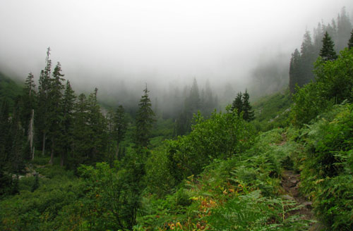
As we climbed higher we left the forest and found open slopes with a beautiful gray background. Sigh. No views. At all. Lame.
Still, when we arrived at Point 5700 we hung out around the big cairn for a bit and marveled at the freaky spider that was still hanging around. (Actually, the cairn was below the summit of Point 5700.)
The trail continued along the ridge up and down, but with nothing serious. Until, suddenly, we were looking for the trail that wasn't there along a nasty rocky ridge. Joseph poked around until we saw the trail dropping into the basin. Oh yeah... I remember that detail in the trip reports. This was where we had to lose a bundle of the precious elevation we had paid for in sweat.
So down we went. It was a slippery, nasty trail. We used veggies to belay and there was some butt scooting, but in general it went well. At the bottom of the serious slope we contoured through the basin crossing talus and scree until we found a number of trails splitting up.
We chose one and started up. I think they'd all get back up to the ridge, but ours worked well. From there it was easy to follow a more well defined trail to the base of the summit. Now it was time to put on the helmets we'd carried for the last six miles. Happily, they weren't really necessary. The rock in the gully was very solid and cries of, "ROCK!" were few.
At the top there was nothing to see. No, no. Not true. There was a terrifying drop off on the other side of the actual summit, but after taking a look over the edge I retreated to the safety of the rocks below it. As the others came up we took pictures and had snacks and lunch and had to duck as a hawk tried to land on the summit before it decided we wouldn't be good at sharing.
The climb down was almost as easy as going up. I stopped frequently to play with the camera, but I didn't have a lot of luck so had little to show for the delay.
No surprise, the trip back was a lot easier. It was mostly downhill, except of course climbing back up to the ridge on the slippery trail. And then it started raining. Just a bit at first, but then picking up. Then it was pouring. Lovely. At least we were off the rocks.
Below Point 5700 we met a pair of hikers who were still heading up and cautioned them about continuing to the summit. With the rain and the likelihood it was only going to get worse it didn't seem like a good plan. Plus they'd likely be coming down in the dark. We left them pondering their choices as we continued down.
At the lake we paused for more snacks and were able to actually see the lake and the trees on the other side. We saw a few people on the far bank, but nobody on our side. As we hiked back up to Hemlock Pass (our final uphill) we saw a few other groups who seemed terribly unprepared for the conditions. I'm sure we looked over prepared, but I'm not sure that's really possible.
The long hike back down the Denny Creek trail took longer than it should have probably due to the steady rain. We made the cars just before 5pm, which translated to about 9.5 hours on the trail with maybe an hour of total break time.
Mr. GPS and TOPO claim the route was 12 miles long with a total gain of 5,647 feet, though hat seems a bit high.
Now I'm just hoping next weekend will be sunny so I can claim this was a good decision.