For the record, yes. I do, in fact, compose trip reports and such while I'm hiking. Most of it doesn't wind up actually in the story since I forget most everything in favor of phrases like "Why am I doing this?" and "Am I going to die here?" and lately "Dang, my feet hurt." Still, I couldn't help thinking about what would wind up here in preparation for forgetting it all.
But back to Saturday... er... Tuesday. Oh heck, jump back to Sunday when I took the girls to Baker Lake. Two days later I was home for the day and took Henry up the trail past the falls. Thursday night was the TNAB BBQ on Rattlesnake Ledge. All in all a great week except that on the rather pedestrian Twin Falls trail I somehow managed to get blisters on both heels. I haven't had blisters fo a long time and certainly not from a minor trip like that.
Still, Saturday was a rare all-day, no kids hike so I wasn't going to let burning pain in every step dampen my spirits. No, it would take the weather to do that. All week it had been gorgeous, but starting Thursday night the clouds began rolling in. Typical. I considered calling Daryl and David and telling them we were going even if it was pouring rain, but I left it up to them with only the hint of belittlement should they decide to bail. (Yes, smarty pants, belittlement is a word.)
On Saturday we met at Starbucks in Issaquah since both of them are Plateau Peeps and Amy was already down there and she was heading to Kirkland after anyway. It didn't bode well that David couldn't find the Starbucks ("There are 15 Starbucks in Issaquah!" he claimed, but technically, there are only nine.) However, since he wasn't navigating it didn't seem that big a problem and we were on the road by 9:30.
I rarely hike outside the I-90 corridor because it takes FREAKIN FOREVER to get anywhere else. In fact, it took us two hours to get to Stevens Pass, though we did tour my former homes. On the way to the mountains the weather got worse and worse. A few blue-sky sucker holes opened up, and I had hope, but it was soon washed away by a few raindrops outside Index.
But wait! There... just (and I mean "just") over the pass! Hey bluebird, what's the word? BLUE SKIES! Nothing but blue skies, do I see. Yee ha! Rescued from an early Autumn for a last summer hike we turned onto the Smithbrook road and David tried out his fancy new "truck" and found it performed pretty well on the dirt road. Of course, Daryl pointed out that the Smithbrook road was actually smoother than my driveway so we probably didn't prove much. We made a quick stop to buy a Forest Pass because mine was safely stowed in my truck back at Starbucks.
Finally at the trailhead we geared up and started up the very, very steep trail switchbacking up through a typical east side forest. Unlike the woods on the west side there was little undergrowth and the smell of dry pine hung in the air while the dust we kicked up filled our lungs. Or at least mine and Daryl's. I don't think David was breathing hard enough to get dust in his and anyway there was nobody in front of him kicking it up.
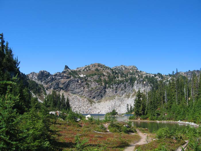
The trail climbs hard and fast gaining about 1,400 feet in a mile before turning to the east on a long traverse. The forest gives way to patches of huckleberries and fewer trees before arriving at Minotaur Lake. Along the way we met only three others. Two were hunters who claimed to have seen a bear and a doe, but shot at neither. The other was a hiker on her way down just below the lake. Strange since there were tons of cars at the trailhead.
Pictures I'd seen didn't do justice to the beauty of the lake. Cliffs lined the north end of the lake with talus along the northwest side. Trails ran to both sides, but reports from others led us to to the east side rather than the route described in books that was more of a scramble to the west.
Over a little hump we met two others with a dog who were gazing down at Theseus Lake, which was perhaps more beautiful than Minotaur. From 500 feet above it the lake was a dark blue with green around the edges and ringing a small island. In the distance we could see smoke from the Domke Fire. We took a few pics of them and continued up through the labyrinth of trails (ha!) with only a few wrong turns. We met one more woman on her way down, but after that we were all alone as we headed up the mountain.
The trail weaves through huckleberries, heather, and huge blocks of granite scattered about. We found a couple of dry tarns and a dry creekbed and views that got better and better the higher we went. At an intersection we wisely chose the path to the west and quickly gained the summit. As we crested over the ridge a cool wind hit us and our sweaty shirts became quite the liability, though the non-stop sun kept us from getting too cold.
All around we could see mountains too numerous to count. To the west the clouds were flowing in from the Sound, but were shredded by the peaks before they got to us. My favorites were Mt. Howard, Glacier Peak, and Mts. Daniel and Hinman, both coated in glaciers. We could just make out the outline of Mt. Rainier to the far south.
I looked for a summit register and was disappointed when I couldn't find it. Daryl mentioned that he didn't see the benchmark (the bronze marker officially stating the elevation) and it occurred to me that maybe we weren't on the summit. In fact, that spot right over there looked just a tiny bit higher. Want to go? No? Losers!
In just a few minutes I had dropped down to a saddle and found another trail up to the true summit. I signed into the register and took a picture of the false summit. The trail that we didn't take to the east looked like it might get up to the true summit, but it was hard to tell for sure. I still think taking the fork to the west was better.
Back on the false summit we surveyed our options for the way down. Books described a scramble route down the west side of Minotaur Lake and it seemed like it'd be hard to get there from the summit. We did see a trail heading out of a dry tarn a ways below and decided that would be our attempt to be adventurous.
After eating and lounging in the sun with the ladybugs that were plentiful we reluctantly packed up and headed down. At the tarn we headed to the west above the lake, but the trail petered out at a short talus field. We looked over cliffs down to the lake, but couldn't find any reliable way down so after a 15 minute detour we retreated to the known trail.
(Looking up from below it's really good we didn't try to force our way down the cliffs. They were at least a couple hundred feet tall and there didn't appear to be a way down. The scramble route actually jumped to the other side of the ridge and traversed the steep slopes to the west.)
As the sun slowly reclaimed the western shore of Minotaur Lake (and the primo campsites there) we left the lake basin and started down the steep trail. As much fun we had getting up going down was even less. Knees ached and the trail seemed to be steeper than ever. Still, it went quickly and we were back at the car before we knew it. It had been about two hours to the summit and about an hour and a half, including our aborted trip around the lake, down.
We had some post-hike refreshments and climbed back into the truck for the ride home. Although we had come in from the west we decided going back over Blewitt and Snoqualmie Passes would be quicker. It also meant we could stop in Leavenworth for a Bavarian Wonderland dinner. (And as a side bonus I could get dropped at home rather than in Issaquah!) Dinner was decent if not good. We met some folks from Oregon City who were up for a long weekend and some geocaching. Daryl couldn't quite buy into the idea, but they were nonetheless excited by the prospect of taking Frank the Wonder Dog out with their GPS.
I got home around 9pm to find everyone fast asleep. After a quick shower I crawled into bed myself and looked forward to a morning of tight muscles and raw heels.
Total distance was about 6.5 miles and 2,900 feet of gain.