Perhaps a month ago I started looking for partners to accompany me on a more aggressive hike. I'd hoped to get up around 10,000 feet on Mt. Hood, much of it on snow. Alas, I couldn't get anyone to join me so I cast about for lesser trips since I don't do crazy stuff by myself.
Luckily, I saw a trip report from a non-technical, snow-free hike on Mt. Hood that would get me up close and personal with the mountain without violating my rules about being stupid. With a good forecast (and a backup hike in case it rained) I threw my gear in the truck when we left North Bend Thursday afternoon in good spirits.
Friday morning my alarm went of at 5am and I popped out of bed. Amy, Henry, and Lilly were all sleeping in the same room with us at Grams and Gramps and I did my best to not wake them. (Clara was sleeping in the living room with Nana and Papa.)
Staying quiet meant I wasn't on the road until about 5:30. Starbucks took a few more minutes, as did gas, but then it was easy going with no traffic as I headed east toward the mountains.
Around Sandy it started raining. My heart fell as I pictured a sodden march through the woods with no views. Had I brought my backup hike plans I would have bailed on Hood and headed for the Gorge. As it was, I had no real option except to continue.
The road up to Lolo Pass was paved, but with unmarked sections of gravel where the road had washed out. Although I got a few glimpses of blue sky I didn't trust in them. After all, they're called "sucker holes" for a reason.
I was supposed to follow Lolo Pass for 10 miles or so, but at about mile four I saw a sign indicating trailheads and camping was to the right while I buzzed by on the left. Uh oh. I continued on through the clouds and found I had made the right decision at Lolo Pass when the paved Forest Service road dropped off to the right. (What's up with paved Forest Service roads in Oregon? Huh?) The next turn I was supposed to make was 0.3 miles before I was expecting it so I passed it by. Finally, I realized my mistake and returned to the gravel road and pulled into the Top Spur trailhead with two other cars that hadn't been driven since at least the previous day.
It was 7:30am and just over the trees I could see blue sky above a thick layer of clouds. Wow. Could I really get a day of blue while Portland was stuck under a marine layer? On previous trips I'd see the clouds blow in and rise up the hills so I hurried to get my gear on and start up the trail.
The first mile or so is the Top Spur trail. It's just a short connector from the parking lot to the Pacific Crest and Timberline Trails. The trail was lined with blueberry bushes that were covered with green fruit down low, but nicely ripe berries higher. There was little underbrush so it was a nice stroll up to the main trails.
I turned onto the PCT after about 15 minutes and then was immediately at the four-way intersection of the PCT and Timberline Trail. Reading the book it described two ways I could go. Left on the Timberline would be the most direct route up the mountain. Right on the PCT would take me along the shoulder of Bald Mountain with some spectacular views of Mt. Hood and down along the Muddy Fork of the Sandy River.
I turned onto the PCT and started down the hill. My maps were less than ideal since I don't have the TOPO maps for Oregon (wah wah wah) and couldn't get to REI before the hike I was using a couple of spotty maps from an online site. The PCT drops pretty quickly and I was surprised, but the trail seemed to be heading in the right general direction. I cursed when I hit switchbacks that weren't on the map. Dang. Down, down, down, should I really still be going down? And isn't the real route over that way? (The other way?)
I stopped and reread the book's description. It still sounded like I was on the right trail. I read a description from the portlandhikers.com site and realized I was on the wrong trail. Worse, I had to regain the 500 or so feet I'd lost on my way down the PCT. At 8:30 I was finally back at the intersection after a 45 minute detour of a mile or two.
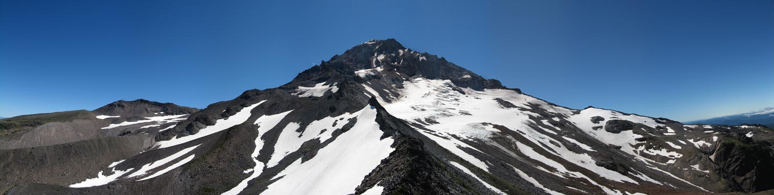
Finally on the right trail, I filled out a permit at the wilderness boundary and continued uphill around the flank of Bald Mountain. I popped out of the woods and had a brilliant view of Mt. Hood, though backlit by the sun. There was almost no snow on this side other than the glaciers, which is a definite contrast to the other times I've seen it.
The trail ducked back into the woods and, right where it was described in the online guide, I found an unofficial trail connecting back to the other fork of the Timberline Trail that would head where I wanted to go. The online guide was amazingly detailed and hardly missed a beat. I had no problems following the trail at all.
The trail climbed through a mature forest with almost no undergrowth, then followed a narrow ridge through a younger, denser forest. At 9:30 I crossed the first small meadow and got another view of the mountain. I pounded a bar, adjusted my boots, and continued up. A little while later I crossed another small meadow and started to head down before climbing again.
I crossed a splashing creek covered with moss and green leaves backlit by the sun. Knowing I was going to need extra water I figured this was a beautiful spot to spend some time so I pumped a liter of water before continuing.
Shortly after I crossed another creek with beautiful blue blossoms still tightly wrapped. Pretty much everywhere I looked were flowers in bloom, too numerous for me to remember all of them. About the only favorite I didn't see were trillium. I guess I can't get it all.
As I continued I'd get peeks at Mt. Hood, which seemed either very close or very far away. The light played tricks on me distorting the distances.
I passed the "ponds" that were really just puddles and could look up the ridge and see the cliffs below the McNeil Point shelter. There was a shortcut trail up there, but it was a scramble and fit into the category of things I didn't do by myself. The regular route continued along the Timberline Trail a little while longer before turning up slope through an alpine valley with stunted trees and yet more flowers.
Flowing on my left was the outflow of the Glisan glacier, milky white and fast. The little valley was mostly devoid of trees, but sporadic tufts of green sported spots of color.
The trail crossed a couple of slopes that usually have snow, but with the hot weather were bare rock. Up high there were few trees. On some of the ridges were ghost forests full of dead trees bent by the wind and bleached white by the sun. Still following the directions from the online trail guide I arrived at the McNeil Point shelter. According to the guide it was built when the Timberline Trail was supposed to go near there, but when it was built lower down it was left stranded.
I had great views up the mountain over a wildflower bonanza and down the way I came. I could clearly see the ponds, portions of the trail, both meadows, and Bald Mountain. I had time and energy so I ate my pbj sandwich and continued up. The trail was narrow and about a foot below the surface, but easy to walk. Up higher it got deeper and steeper more like a staircase than a trail.
Almost at the top, about 1,000 feet above the shelter I started when I saw another hiker above me. He was looking through binoculars so I wasn't sure if he'd seen me so I said hello and stopped to chat when he clearly wanted to. He was way more experienced and talked about climbing Hood and his normal haunts in the North Cascades. (I'm always shocked when people talk about how they'll drive from Portland to northern Washington for a hike when I'm loathe to leave the Snoqualmie valleys.)
I left him and continued up to the high point at almost 7,000 feet. Right in front of me were the Sandy and Glisan glaciers and a spine of crumbly rock leading up the mountain. Cathedral Ridge, a popular climbing route was off to the left a bit and Barrett Spur, the high point on the west side of Hood was a mile or so away.
I dropped my gear since my climbing was done and sat down for a few minutes of rest. It was about noon so I figured about three hours of actual hiking to get this far not counting time talking with the one hiker I had seen and my silly detour down the PCT. I took many, many pictures before deciding I needed to head down. McNeil Point was a great place to hang out, but Amy and the kids were expecting me back in Portland.
The route down was the same as up, but with 29 times the hikers. I talked with one guy who said the next ridge over (Yocum) was his favorite, but it was way too long now that the bridge was washed out. We also talked about blueberries and huckleberries and whether they are the same or different. He contended that blueberries were cultivated while huckleberries were what grew in the wild even if they were blue. And the pink berries in our backyard? Also huckleberries. I'm still not convinced, but you can bet I'll look into it.
I pumped another liter of water lower down to ensure I wouldn't be dry and stopped a bunch to pick whateverberries. By the time I got back to the car I had a big bunch of them, but a wind gust blew them off the top and all over the ground. I guess the girls wouldn't get a sample after all.
The drive back was uneventful and quick. I had a craving for salt so I stopped for a Slurpee and a bag of chips, but got back in time for dinner. I don't think I made it past about 8pm before I was falling asleep with Henry on my lap. He and I slept very well that night.
Total mileage with the detour and everything was about 14 miles and 4,500 feet of gain.