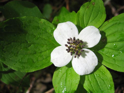
Bunchberry is one of my favorite flowers and was all along the route to Kanim Falls.
Wow. It's two days later and I still ache. A hike hasn't beaten me up like this since... the last time I tried to go up the North Fork. Hmph.
At 9am it wasn't raining, but the forecast called for "showers and possible thunderstorms" so I had a bag full of Gore-tex in the back of the truck as I waited for two new hiking partners to show up. Both were waterfall fanatics and agreed to the trip to Kanim Lake so they could take pictures of the falls where the North Fork of the Snoqualmie flows out of Kanim Lake and over a 200 foot cliff.
The falls were neat and everything (wow, understatement of the year, it was spectacular), but I wanted to get to Kanim Lake. Way back when (um... 2003) we slipped a little bit of water from the source of the South Fork into the baptismal font for Clara.
In 2005 we used water from Lake Lillian and the headwaters of the Middle Fork of the Snoqualmie for Lilly.
Now you can see why we had to have a third kid. There are three forks of the Snoqualmie. Duh.
By 9:20 Anthony and Bryan were in the truck and we headed up the North Fork county road. Just about everything bad that can be said about a road should be said about this one. While the county and the Forest Service are shining up the Middle Fork road the North Fork is developing huge holes. Worse, a key bridge over the river is being replaced and the upper reaches of the drainage will be closed to all but a few with special permits. (Yes, I have a permit, but nobody to hike with me up there.)
An hour later we were at the end of the road. Literally. We parked, geared up, and headed down into the woods. Last year I conned Dan into a trip into these parts and we started from the same spot. The first part of the trail was just as I remembered it, but with more flagging so the spots where you could easily take a wrong turn were pretty well eliminated.
The trail goes through new growth forest with lots of underbrush and then enters older forest where the floor is barren and little light gets through the canopy. This isn't necessarily a bad thing. It made it easy to follow the faint footpath and flags along the river.
This trail, however, ended at the river headed up toward Paradise Lakes. That was the route Dan and I took last year in an attempt to get up to Lennox Peak only to be denied and eventually risk life and limb (nah, no chance we were losing just a limb) to get home through brush taller than we were.
So the three of us poked around on the edge of the forest looking up the valley. Our choices were to jump in the river and walk upstream (actual route advice I gathered while planning the trip) or cross a ferny meadow. We chose the ferns and started our bushwhack proper.
Half way across we stopped to admire the waterfalls coming out of Paradise Lakes. From down here they looked massive and the two waterfall guys set up to shoot pictures. I took pictures of them taking pictures. (When commenting about cameras they both agreed that although I had just a point-and-shoot at least it was a Canon.)
Right away it was clear that fallen logs were our friends. They provided a (usually) solid surface to walk through the brush on. The only hard part was getting on and getting off. We used logs throughout the trip and I don't think anybody actually fell off one.
After the ferny meadow we were back in the forest, but it was different now. More light got through so we saw more underbrush. Bunchberry and Queen's Cup were blooming and looked great. Every once in a while the rain would stop and the sun would poke through to light up the flowers that sparkled brilliantly.
As we continued the going got tougher. From the low flowers we saw thimbleberry and salmonberry. Then blueberry bushes with thick woody stalks and finally, the king of all brush: Devil's Club. Oh how we hate thee, Devil's Club. The thorns pierced all but the toughest of clothes and the tiny black tips break off under the skin and almost guarantee an infection.
Just as we got our first glimpse of Kanim Falls the sky opened up and the rain began in earnest. We took shelter under some trees and had lunch. We had made perhaps a mile in two hours. Not bad, actually. Not good, but not too bad.
From our lunch spot we decided to head down to the river where we hoped to find a rocky shore we could follow to the base of the falls. To get there we had to fight maples and alders and holes hidden by bracken. We emerged from the brush and I believe my exact words were, "Where's the freakin' river?"
The tiny trickle in front of us didn't sync up with the vast quantity of water falling over the cliffs around us (we were surrounded by waterfalls at this point) to say nothing of the rain. As near as we could tell, most of the river was underground. In fact, as we walked upstream just a little way the river disappeared completely. It magically bubbled up from beneath the rocks and off it went.
On the upside, we were on rocks now. Mostly. It was easiser going as we pushed toward the falls. Don't get me wrong. It's not as if the only hard part was getting to the river, but climbing over talus was a lot better than wading through brush.
We climbed higher and closer to the base of the falls until we were stopped by alders and Devil's Club. It seemed a good spot to stop so the guys got out their tripods and I bashed a hole through the brush to the talus field to the north that led to the base of the cliffs.
When we were planning the trip we identified a couple of challenges. The brush, the weather, and the cliff. Info we had gathered indicated there was a steep, but hikeable route up the 200 foot cliff and that in spots there was a rope that could be used to assist. I even had some rough idea of where it was.
Unfortunately, it wasn't there. We found hints of a trail and steps that looked too uniform to be natural, but always they petered out and we were left pulling ourselves up the hill with the help of the blueberries we had been cursing shortly before. 400 vertical feet short of the lake we made the smart decision and gave up. My GPS showed we were too far to the north, but I still think the route might go.
It took four hours to go about a mile and three quarters and gain 1,200 feet.
Back at the base I traversed to the base of the falls to get some of the water. It was remarkably cold and clear for a mountain stream.
We followed the rocks to the source of the river bubbling out of the ground and then charged back into the brush. We probably spent too much effort trying to retrace our steps rather than just finding the best route out. All along we'd discover pieces of what looked to be a manmade trail, some even with potential footprints. (Heck, Anthony thought he heard voices on the way up.) However, until we got back into the forest and saw flags we weren't following any path other than that of least resistance.
The way back was about three hours.
At the car I changed into dry clothes and we sped home.
Now I ache and my legs are bruised and cut even though I had pants on. My shoulders and arms hurt from pushing aside branches and hauling my pack and I've yet to get all the Devil's Club thorns out of my fingers and one is starting to turn colors.
And in the back of the fridge is a liter of water labeled, "Kanim."
(Total distance was 3.5 miles and 1,200 feet of gain in seven hours.)