Way back in June of 2000, when Tokul was just a wee pup, we took her up Rattlesnake Ledge and then to see Tokul Creek, which of course was named after her. Where Tokul Road (also named after our dog, sheesh) crosses the creek there's a bridge and a little pull-out. We had parked there and scrambled down the bank to play in the water. On the way out we noticed a sign for a trail heading into the woods called the Tokul Creek Forest Trail, but that was the last time I thought about it.
When casting about for an easy, but new trail for the girls I recalled the Tokul Creek Forest Trail and thought it'd be worth a go. Clara opted to go shopping instead of hiking (the first of many such confusing choices, I'm afraid), but Lilly was too young to make any such choice so I packed her and Tokul into the car.
The trail starts just beyond the bridge with an old sign and a kissing gate. The gate was so tight I scraped the sides with the backpack as I pushed through. On the other side were some overgrown picnic tables and a bunch of blown down trees. After navigating the branches the forest opened up a bit and the trail switchbacked down toward Tokul Creek.
There were lots of trees down across the trail, but none were too problematic. The trail drops quickly, bottoming out at an impressive Douglas Fir. The creek was still a ways below and it was clear the trail was just going to head back up to the Snoqualmie Valley Trail and the trestle/bridge over the creek that I could see through the trees so with Lilly's approval we followed a faint trail heading down toward the creek.
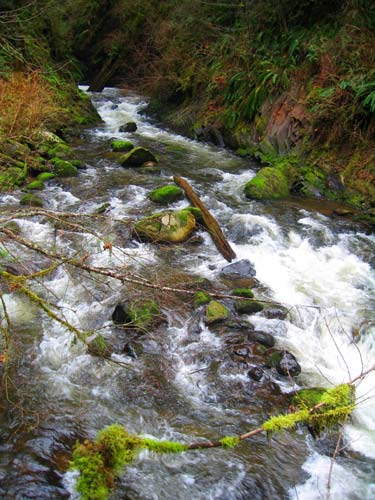
The way down was slippery and we had to backtrack a few times, but in general it wasn't too hard to get to the creek. We wound up right below the joining of two channels and a tributary. After bumping Lilly into some branches I tried to go under (stupid backpack) I popped her out and we followed up the side channel to a cool little gorge. There was a small beach with loads of rocks for Lilly to throw and Tokul had a blast splashing about.
Preparing for the arduous journey out (it'd been a full quarter mile to get to this point, after all) Lilly had a bar or at least about half the bar before Tokul snatched it from her hands. Lilly didn't mind, though, so after we passed the attack branches we saddled up and were soon on the Snoqualmie Valley Trail and the big trestle over the creek.
The trestle was high enough that it made me a little dizzy looking down to the creek, but it was probably no more than 50 feet or so. Nonetheless, it was a good view up and down the creek.
On the far side we found a very faint trail switchbacking up the hill. If it went back to the car it'd make a perfect little loop. Since it was only a short detour if it dead ended we headed up. At the top of the hill it intersected with an old road that ran into another that finally turned back into a trail. There were some flags that I thought were going in the right direction so I followed.
At the base of a small hill the trail headed off to the east (I wanted to go north), but a really, really faint scratch went up the hill. I followed and found it just ended at an old geocache. Bummer.
However, from the vantage point I could see through the open trees well enough to get back to the road, which wasn't more than a coupld hundred feet away even if there was no trail. (Of course, there was a trail, it was just closer to the creek.)
Overall, it's a neat route. Really short, but with a gorgeous creek and plenty of spots for exploring and playing and all that. A mile for the loop is probably pushing it a little bit, but 350 feet of loss and gain seems about right. Definitely worth another visit on a day when we could get into the water ourselves.