The plan was pretty simple. Meet up with the TNAB Lunatics, hike toward Annette Lake, summit Silver Peak, marvel at the views, come down, go to bed.
Great plan. Lousy execution.
It was perhaps a tad ambitious to attempt a 3,728 foot climb in six miles in the middle of winter... at night. I'd been on Silver Peak twice before (July 2003 and June 2006), but both times it had been via the PCT on the east side of Silver whereas this approach was from the west side.
Nonetheless at 6pm I found myself on the bridge over the South Fork just downstream from the Annette Lake trailhead. In the summer Annette Lake is packed. The Forest Service has a huge parking lot to accommodate the throngs and even then you often have to park on the side of the road.
On a Thursday night in the winter, however, there was no problem finding a place to park. Not that we could get to the trailhead. Snow and ice made it sheer folly to try to drive off the bridge at the I-90 off-ramp. I parked by three other cars and started gearing up.
Carla, who was lending me crampons for the trip, came over and told me nobody was bringing snowshoes. Back in the car they went. All packed up I wandered into the midst of the group. In addition to Carla I'd be hiking with Chris, Mark, and Jeff. All were TNAB vets that I'd hiked with before.
The road to to the trailhead was mostly ice. Carla had her crampons on already so she had no problems, but the rest of us slipped and slid much of the way there. As we started up the trail we quickly realized it was far too icy to be without traction aids. I got out my borrowed crampons and realized (with help) that I didn't have the required welt on my boot to attach them properly. No problem, though, Chris lent me his universal crampons (that didn't require a welt) and he stepped into Carla's.
While we were working on this Dan and Larry, two other TNAB hikers, came down the trail. They had been up a ways, but had turned back due to the icy conditions. It was only when we were ready to go that I realized that Jeff didn't have crampons or an ice axe or even poles. Jeff regularly does hardcore trips, but rather than bravado it was a lack of warning that resulted in him going forward in just his trail runners.
The route was easy to follow. Even with the snow and a couple avalanche chutes the route to Annette Lake is very popular. Add to that the fact that it hasn't really snowed much in the last few weeks and we were walking along a well packed and somewhat ice-covered trail. Only Jeff had much difficulty as the rest of us had between 10 and 12 sharp metal points on each boot thanks to the crampons.
The trail switchbacked up the hill, over Humpback Creek, and across the Iron Horse trail. The sign marking the Annette Lake trailhead was all but buried, but there was little doubt it was the trail. There were no views along the trail. The moon (a day from being full) wasn't yet over the ridge so even had the trees opened up there wouldn't be much to see.
Shortly we were at the gully we wanted to follow to the summit. This trip was only possible because the avalanche danger was as close to non-existent as you can get in the winter. The snow was consolidated and quite hard. As we followed the gully up we had to kick steps into the thick crust with the crampon's toe points to get a foothold. I should have had my axe out, but poles made it easier to climb so I stuck with those.
At the top of the first chute we crossed back into the trees and traversed while climbing slowly until we came to the next open slope. Once again we turned straight up and kicked our way toward the summit.
Unfortunately, time, sore heels (a common problem in crampons), and a need to be conscious at work the next day conspired to convince us we ought to turn back. We were at about 4,500 feet and about 1,000 feet short of the summit. We figured it'd take us at least another hour to get to the top and we were already about two and a half hours in.
Looking down I was confronted by the steep pitch and elected to swap poles for axe. I had taken no more than a few steps in the awkward crampons (my first time using them) when one of my heel points caught the crust and I started to fall.
It always amazes me that after only one time practicing self-arrest techniques most of the concepts come flashing back when they are needed. I wound up sliding about 15 feet down slope before I came to a stop with my pick buried in the snow. Good times.
I got up and started down again. I realized that if I stepped first with my heel and broke through the crust I'd be in better shape... mostly. I had another fall and another arrest that again reassured me that I could handle myself on a fairly decent pitch. As we cut through the trees I did pretty well and I didn't fall at all on the second slope. Jeff, unimpeded by crampons, did a sitting glissade down much of the second slope making me almost consider taking off my crampons to follow him. (Glissading with crampons can be dangerous. If your points catch the snow you can turn and break an ankle. Not that I'd know anything about that.)
Back near the bottom of the slope where we would pick up the trail for the slog out we carved seats in the snow and sat down. I broke out the hot chocolate, but Mark trumped it with birthday cupcakes for Carla. (Carla shares a birthday with Amy and Grandpa Jack. Hey... that means Amy and Grandpa Jack share a birthday, too! Freaky.) In addition to the sugar hit there were beers and a bottle of Wild Turkey that somehow was mostly consumed by the time we left.
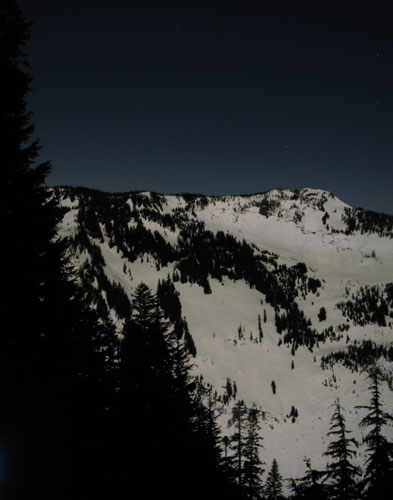
I shot loads of pictures as the moon finally rose over the ridge. The full moon at this time of year is called a "snow moon" because it usually appears over snow. At least that's what NPR said. regardless, it was majestic as it lit up the slope we had struggled up in the dark and Humpback Mountain was bright to the west.
After about 45 minutes we all began to get chilled. I had even put on my emergency wool sweater and was considering getting out my fleece pants when we decided to go.
We left the moonlit slope and entered into the dark woods. The snow had hardened significantly since we passed through a few hours earlier and Jeff had a harder time without crampons. Of course, even with crampons I went down (after I'd put away my axe, of course) and started sliding down a small hill. Back came the training and I dug in my toes and popped back to a standing position. SWEET!
At a series of switchbacks we left the trail to cut off some distance by heading straight down. It was a blast heading down the slope instead of up or even traversing, but we started to get a little antsy when the trail didn't reappear. I was sure it was below us as we started looking for the trail in earnest. Chris was leading and headed down and to the north. When the contours turned to the northeast we headed more down on the assumption that we had to run into the trail eventually.
Yeah... right. Jeff took the lead at a little creek crossing and started back up the hill while traversing. We had to bash through some brush, but amazingly we found the trail ABOVE us, not below us. Dang. Oh well, now we were back on the trail.
We continued on the trail making good time until we came to another set of switchbacks below the Iron Horse. With a pretty good idea of what was ahead I charged down the hill cutting switchbacks. The slope petered out and I wandered through a mostly flat area until I ran into Humpback Creek... except I needed to know where the bridge was. Clearly the bridge must be upstream so I started following the creek to the south.
Of course, after a while the others came to their senses and reined me in. We headed downstream, which I was sure was wrong. We'd wind up at the South Fork and then we'd have to follow that downstream to an unbridged crossing of Humpback Creek. That's when I'd chuckle under my breath and think, "I told you so." All was going well until we found the trail. WHA?! Happy I hadn't been more adamant the bridge was upstream, I followed the rest of the crew down toward the cars, stopping only to try to shoot some pictures of Humpback Creek from the bridge.
In the trailhead parking lot the moon was so bright it was like being under the night skiing lights at Snoqualmie Pass, but without the threat of being run down by a snowboarder. (Of course, there might have been a bear or jaguar or something, but I think snowboarders are more dangerous.)
Only a few minutes later we were back at the cars and 15 minutes after that I was at home. It was just before midnight and just after midnight after I took the trash out to the paved street.
Even though we didn't summit it was a great trip. "Epic" was one description courtesy of the climb up the slopes and the off-trail adventures, but definitely a trip I'd like to try again, though maybe in the daylight.
Totals were 5.26 miles and 2,664 feet of gain. Both of these numbers are from TOPO (the mapping software I use with my GPS) and don't take into account our detours as we went off-trail, but it's probably pretty accurate. We peaked out, so to speak, at 4,541 feet. The summit was 1,064 feet above us at 5,605. It'll be there when I try again.