When I first heard I'd be spending the week between Christmas and New Year's in Sun River in Central Oregon I flashed back to Snowhouse II. We had rented a house in Sun River with the Grays and Irvines and snowshoed and skied around Mt. Bachelor. Five years later I was looking forward to snowshoeing all over the place. Although the bulk of the trips would be with Amy and the kids I had one more aggressive trip planned with a local.
I had fumbled around with guidebooks and trip reports looking for a good place to go that would be challenging, but not death defying. My first suggestion was South sister, but at 10,000+ feet and a LONG approach that was clearly not realistic. A few other busted pipe dreams later I was at the corner store meeting Gevin to head to Paulina Peak. (That's Paul-eye-nah Peak, not Paul-ee-nah.)
Paulina Peak is the highest point on the caldera rim in the Newberry Crater National Monument. At just barely under 8,000 feet it promised a challenging, long trip into the kind of terrain I rarely get to experience in the central Washington Cascades where peaks typically top out under 7,000 feet.
Gevin delivered us to the 10-mile sno-park by about 9am. There were a bundle of snowmobiles around, but we would be following the ski trails, not their groomed trails. Gevin would actually be skiing, but since I've never been able to get the hang of cross country skiing I stuck with my trusty snowshoes. I broke trail next to the established ski track. The snow was light and powdery, likely due to the single-digit temperature.
The first three miles of the trip gained slow elevation from the sno-park to Paulina Falls. The outlet from Paulina Lake splits into two channels and spills over a ledge as a pair of waterfalls. Icicles lined both falls and the river channel below was full of ice-covered boulders.
From the falls we quickly arrived at the lake or at least the summer parking lot. It was around here that we saw the first snowmobiles since the sno-park. Ugh. To be honest. I was bummed. I had hoped to be done with the snowmobiles miles before, but it wasn't too be. Ok. All done. No more complaining. Thpth.
From the lake lot we found a sign showing the route to the Paulina Peak and started that way. Pretty quickly we were on a well marked and trod route heading up. (Trod by snowmobiles. ARGH! (Ok, I promise. No more.)) For the first few miles it was mostly a slog. The views were restricted by the trees lining the route as it switchbacked up the inside of the caldera and the snow was just like the snow I see all the time. However, from time to time a peek of the mountains to the west (Bachelor, the Sisters, Broken Top) would open up and it was clear it was going to be great.
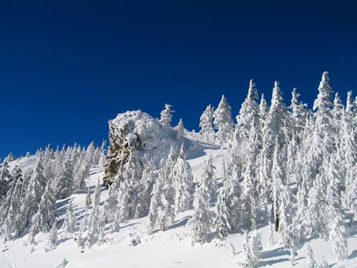
Oh yeah. Did I mention the weather? Perfect blue skies. So blue they were almost black. Wow.
As we crested the rim of the caldera and continued to climb the trees were coated with ice and snow. Against the dark of the sky the trees almost glowed. Gevin and I were well matched on the uphill. The only problemw was an almost overpowering need to stop and take pictures of each new view.
From a distance we could see a high point, but GPS indicated it was farther away than what we were looking at. When we arrived it was clear we weren't at the summit. However, it looked like there might be some views on the other side of the rocks where we were so I climbed up over the ridge and stood in between two huge rocks coated with ice. The snow in the saddle was sculpted by the wind into knife edges and a hard crust.
After way too much time taking pictures I turned back and saw our true destination. Like a little model made of styrofoam a building stood against the blue sky among a few trees below a final high point.
We started up again and while Gevin continued on the broken trail I cut the switchback through new snow and trees bowed under the weight of the season's ice.
The overlook, driveable on a dirt road during summer, provided views of the Cascades, both lakes, and the high desert. A short way above was the true summit, which of course, was where I had been trying to get to all along. Gevin went to check out the shelter and I climbed up to stand on the high point at just under 8,000 feet.
We could see ski tracks heading down, but their route was extremely steep and a little reckless to us. Instead, we got out of the wind behind the shelter. The windward side of the shelter was thick with ice that looked like the decorations at the top of Roman columns. Out of the wind and in the sun it was actually quite pleasant. We had some cocoa and a bite to eat before starting down.
At the next switchback I could see a way down through a meadow that would cut a bundle of distance off. Gevin headed down the way we came up while I broke new trail down the gully through ice-laden trees. We met up right where we thought we would and continued down together.
Gevin clearly had a massive advantage given his skis. I had to continue marching along and even though it was downhill it was still a very manual process. Gevin was able to glide along using gravity to his advantage. There's a lot of skill required (I've tried three times and I could never get the hang of it) and a bundle of muscles in use, but as he disappeared around corners while I continued the march it was clear he was going to be doing a lot of waiting for me.
He did an extra bit of waiting when I realized I was in the midst of my second equipment failure of the trip. My sunglasses frame had broken at the summit, but a snowshoe failure was a much more serious problem. I could squint or pull my hat down low over my eyes, but without a working snowshoe I would be in real trouble.
One of the rivets that holds the footbed to a couple of straps from the binding had sheared off. The shoe was still functional, but at risk of complete failure if the straps completely unraveled. I dug through my pack for something I could use to complete a field repair and found the lanyard from a little flashlight in my emergency kit. It took about five minutes and it wasn't tight, but it was stable and looked like it would serve to get me the remaining five or so miles down the mountain.
By the time we were at the lake I was tired. Really tired. Breaking through the snow crust with each step became a real chore. As we headed back toward Paulina Falls I was thinking of little other than not falling too far behind. At the Falls I was thrilled to see the light was better than when we were there earlier in the day. I was even more thrilled when Gevin suggested we should follow the snowmobile road from the Falls back to the sno-park.
Gevin dropped me at Snowhouse by 5pm just as dinner was being served. Although I was required to eat standing at the bar instead of seated at the table with the clean-smelling folks I considered myself lucky to have seen the brilliant views I had and been able to enjoy dinner with the family.
I made Gevin promise to get in touch with me when he came up near home, which he does somewhat frequently. (Heck, he even knew where North Bend was.)
The total distance was about 14 miles and 2,440 of gain.