In the Big Book of Not Quite Ideal Plans (available by the 2007 holiday buying season) starting a big day of hiking at 2:30am with a call from work appears on the first ten pages. (Coincidentally, the next entry is building a major freeway interchange over a river in the middle of a city. Go figure.)
After squeezing in an hour of sleep after work was taken care of I got up at 5am to head to the trail. I had to be back by 3pm so time was of the essence. Happily, the Starbucks was open and had piping hot breakfast sandwiches to accompany my caffeine. Surprise, surprise, no one else was crazy enough to be on the road at 5:30 so I made spectacular time heading through Portland and out the Gorge.
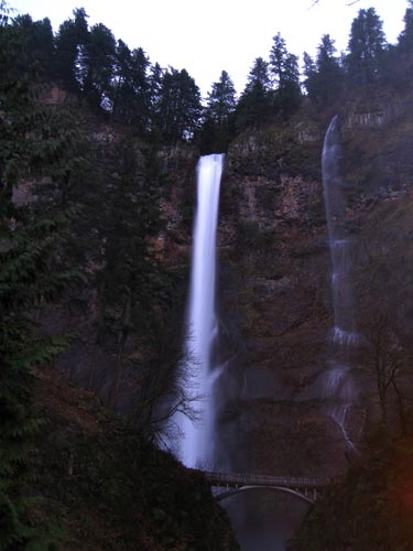
Unfortunately, I made such good time I found myself in the Multnomah Falls parking lot in the pitch black at a little after 6am. Dang. (True, I had my headlamp, but I wanted to see what I was hiking past so I opted to chill in the car for a short while until I could see my hand in front of my face.)
An hour later I was on the trail. The first half mile was on the "Return Trail" that runs along the highway from Multnomah Falls to Wahkeena Falls. The heavy rains had both waterfalls roaring. The trail wasn't at all muddy... because it was paved. (WHA?!) Both these waterfalls are major tourist attractions so the pavement shouldn't have been such a shock, but it wasn't exactly what I had in mind.
From just a few feet above sea level the trail up Wahkeena Falls climbs steeply to Lemmon's Lookout (named for a fallen wilderness fireman) and then even more steeply up the Wahkeena gorge. All the creeks in this area are deep in troughs they've carved from the volcanic rock making them dark and mysterious.
An hour from the car I turned off the trail toward Wahkeena Springs. Just a short way down that trail I found Wahkeena Creek springing (get it?) from the ground. SWEET!
(It's important to note that although I could see the general contours of the land I had little idea what names like "Wahkeena Springs" or "Angel's Rest" would look like. Although I talked with some folks about the area, I didn't have a good feel.)
From Wahkeena Springs the trail descended as it traversed to the west toward Angel's Rest. The first part of the trail was beautiful. It passed through a mature forest with little undergrowth. Unfortunately, the trail too quickly left this and entered into a snag forest full of dead trees and salmonberry bushes. Hmph. Although the trail followed the edge of the ridge there were no views to be had. Double hmph.
As I pondered abandonning the trail and turning back I saw a sign pointing to Devil's Rest. I knew that trail was just a short distance from Angel's Rest and continued with renewed energy... except it wasn't the trail I thought it was. Dang. Just as I was really wondering whether I'd wind up back at the river I passed another trail to Devil's Rest and shortly thereafter Angel's Rest.
Along the trail I was thinking I'd tell others to bag Angel's Rest because the route there was pretty lousy. However, upon arrival I changed my mind. Angel's Rest is a rocky finger jutting away from the ridge and towering 1,000 feet above the Columbia River. Darn cool. The trail runs all the way out to the end.
The wind was really howling by this point. At Angel's Rest I felt like I was being pushed around. As I returned to the forest I kept my eyes on the dead trees above and the branches that had already fallen across the trail.
Like the Angel's Rest trail the Devil's Rest trail started out really nicely. It climbed gently through mossy maples and huge old trees covered in green. Unfortunately, it too deteriorated and soon I was walking up an old logging road. Devil's Rest was the high point of the hike at about 2,400 feet, but there was no view from there. (My Portland contact had warned me of this telling me that I'd arrive there and say, "Uh... am I here?")
It had taken an hour from Angel's Rest (three hours from the car) and I was in need of a bit of snack. I'm a sucker for Starbucks' chocolate chip cookies and when they're cold they're even better. Fueled up, I started toward Multnomah Creek. The trail runs along the ridge, but by now the clouds that had threatened all day were thick and there were zero views where there should have been at least something. Then it started to snow. Yay.
I stood under a tree studying my map. It looked like I could jump onto a road and skip a big downhill and an even bigger uphill. I had a fleece hat on and my hood up over that to ward off the snow, but there was no mistaking the sound of antlers on a tree. I shouted a couple of times and decided it was time to move along.
The trail dropped quickly and pretty quickly I was back on the main trail, just 0.4 miles from the Wahkeena Springs turnoff. I met a couple from Minnesota who were considering heading up to Devil's Rest. I gave them my opinion and headed toward Multnomah Creek. (I don't know if they went up or followed me at a distance.)
When I arrived at Multnomah Creek, an hour after leaving Devil's Rest (amazing how each leg was almost exactly an hour, huh?) I looked at my watch. It was about noon. I was supposed to be back by 3pm or 4pm so I had plenty of time. It looked like I was only about half an hour from the car so... I headed upstream.
Multnomah Creek was roaring. The trail followed the creek closely. Too closely, in some cases. A sign points to the "high water trail" for those times when the creek flows over the trail. Luckily, the water wasn't quite that high so I was able to walk on the rock shelf next to the water.
The creek received contributions from countless little waterfalls cascading into the torrent from the cliffs above. I was so entranced by the beauty I was surprised when I came to the Multnomah Basin road. I had intended to following the suggestion of my Portland contact, Jeff, and heading to Nesika Lodge and Cougar Rock, but that trail branched off the high water trail I had passed on. (Dang.)
I looked at my watch and considered making a stab at Larch Mountain, but since it wasn't on my map and would be at least another three miles out and then six miles back (to say nothing about the vertical gain) I saw a trail on the map that climbed to a point at 2,000 feet. The Franklin Ridge trail wasn't too special, but there were some cool sights as trees emerged from the mist, but overall... (Looking at another map it appears that right where I stopped on Franklin Ridge there's a trail that spurs off (I followed it a short way, but it was in poor shape so I turned back) and heads right toward Nesika Lodge -- my original destination. ARGH!)
If you were counting (I was) you'd realize I'd seen two people all day. Cool. Now, however, I was heading straight into the teeth of the world. First I saw a couple. Then three more. Then the state of Montana. I gave up standing to the side as people were climbing the hill and saying hello. They were all pissed at the rain and the hill and not terribly interested in making friends.
Multnomah Creek had a few pretty cool waterfalls upstream from the big falls, but my camera chose this last point to fog up so I had few quality pictures. (The battery later failed and something inside got foggy, but we'll pretend that didn't really happen.)
Back at the car I started peeling off my gear. Boots, socks, rain pants... everything was steaming after six and a half hours on the trail. Later I'd tell Amy I was bringing home a "special kind of funk." That funk would sit in a plastic bag in the car for the next three days.
Total distance was 14.07 miles and 5,091 feet of gain.
BTW: Leaving a bag of sweaty, wet clothes in a car for three days is on page 24 of The Big Book of Not Quite Ideal Plans.