At the beginning of July Daryl and I picked out July 30 as the target for an all-day hike. We had to plan that far in advance due to Amy's intense training schedule for her walk. Sure, it was a gamble since nobody can predict the weather that far in advance, but it's the end of July so it'll probably be good.
In fact, as July wore on it looked more and more like we were going to be sweated off the trail more than anything else. The weekend before featured record-breaking heat and the week leading up to Sunday was nothing but blue skies. Even Saturday was decent. A little overcast, but nothing too bad.
Sunday morning was, as forecast, lousy. The temperature had dropped 40 degrees in seven days and a marine system had moved in. We had planned a hike with lakes and meadows and a summit near to Snoqualmie Pass, but it was clear that wasn't to be. Luckily, I had picked a hike further east in the Teanaway Valley that might be a little drier.
As Daryl, Tokul, and I sped across the Pass (stopping for a day-use permit in leiu of my annual permit conveniently located in the truck with Amy) the rain began to fall in earnest. Beyond the Pass we could see blue skies and it appeared all would be well. I kept one eye on the road (most of the time) and the other looking to the north where clouds were building and I thought we'd wind up.
The Teanaway Valley is north of Cle Elum (more or less), but we had to drive east and then north toward Blewitt Pass before returning west through the Valley. The area isn't one I've been in before, but I'd heard such great things it was a wonder I'd stayed away so long. (No doubt due to the long drive and the immediate availability of local hikes.)
It took two solid hours from the Moosefish Estates to get to the trailhead located on the North Fork of the Teanaway River. After gearing up we were on the trail heading up to Iron Peak.
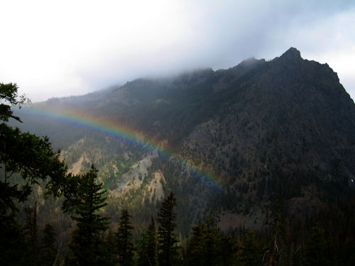
As with every other time I find myself in a forest east of the Cascades I kept thinking about how different it was compared to the west side forests. There was virtually no undergrowth and only sparse trees. The first portion of the trail climbed steeply, but gave us great views to the south to Esmerelda Peaks and a rainbow in the valley below us. (Never mind the rainbow meant water in the air and that meant the storms were approaching. It was still cool.)
The trail switchbacked relentlessly for the first half mile or so, but then leveled out. It still climbed, but in a much more sedate way. We met only two other hikers on the way up. They'd been out for several days and were coming down this trail before walking the road back to their car.
Before we knew it we were at the saddle looking down toward the Beverly Creek valley. Iron Peak was up the spur trail to the south across a barren, rocky landscape. A lone patch of snow sat at the base of the last hill. Tokul ran to tromp in it, but didn't spend much time there. The final climb was steeper than any other part of the trail, but short.
We walked along the ridge past trees that had been killed by the harsh weather and now just stood as a warning to any others that might try to gain a foothold there. We passed through a gully sheltered from the cold wind and pushed on to the summit itself.
Actually, Tokul and I pushed on to what we figured must be the summit, but Daryl called us back when he found the summit register. We read the entries, mostly written on trail maps, and found the most recent. "And God said let there be light! A glorious day with no clouds." That was a week before. I wrote our names and added "I wish there was light. It's snowing." It had, in fact, just began to snow.
We continued to the second "summit" just along the ridge and found a polished stone with the word, "Connection," etched into it. (No idea what that's about, but took a picture of it.) Daryl and I were both getting chilled by the wind so we retreated down the trail to the gully for lunch.
Just as we found shelter from the wind the sun popped out and started cooking us. It made for some better pictures of the flowers and freaky plants, but then it disappeared and it got cold again. We held out hope that the clouds would clear and we'd have the vistas I had expected, but it became clear we wouldn't be so lucky. The final straw was when the snow began coming down heavily. It didn't last, but that was as clear a sign as any that it was time to head down.
On the descent to the saddle we were treated to one, brief, view of Mt. Stuart between two unnamed peaks. (I tried to convince Daryl to make a scramble out of the one just to the north of the saddle, but he wisely declined.)
The trip down was pretty uneventful. We didn't see the bear or deer or goat or marmot or anything we'd hoped for. We did come back through a tiny little area as green as any spot on the west side and full of flowers. There must have been a spring there and in fact it might have been the headwaters of Eldorado Creek though there was no water on the surface.
The only other human encounter we had was a group of four in Tevas heading up. They asked how far and we let them know they were 1,000 feet short of the summit.
At the car we flipped through the guidebook (I know, blasphemy) for something short and easy since it was barely 1pm, but decided the whole area would be cloudy and not worth the effort. At Snoqualmie Pass the rain was coming down in sheets so even though the weather wasn't perfect on Iron Peak I felt like it was a lot better than it would have been at our original destination.
Total distance was about 7.7 miles and gain was roughly 2,500 feet. We hiked up for and hour and 45 minutes, spent an hour and 15 on or near the top, and took only an hour to get down.