I wasn't about to turn back now so I hung it up and hoped any ranger who saw it would be having a good day and let it slide.
Wrapped in Gortex Tokul and I started up the trail. It begins as a Twin Falls sort of trail. Big, wide, and flat. It runs right along the river. Looking up I could see a big rock wall hanging over and dripping down on the trail. I hurried past this thinking with my luck anything that fell would hit me just off center enough to severely wound me, but not quite finish me.
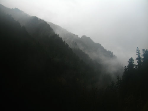
The trail began a slow climb through the woods with the creek a constant roar in the background. I figured it'd be like Twin Falls in that it would vaguely follow the water while switching up and down the hills. However, this was a different model of trail building. These folks decided to stick right with the river even when they had to blast the trail out of the cliffs. This made for some striking views and some rather terrifying ones as I kept Tokul on leash and my other hand white-knuckling the cable bolted into the cliff face.
The first falls we came to was Metlako Falls. It was off the trail a bit so we could only see it from an overlook a couple hundred yards away. It looked as though it burst from the cliff and shot out over the pool. As I was trying to get some pictures I realized it was going to be a tough day for the camera. The constant rain was soaking it along with everything else and the heat from me was fogging it up fiercely. Oh well. Onward!
Just a half mile later was Punchbowl Falls. I took the trail marked "Lower Punchbowl Falls," but was disappointed to not be able to see the falls themselves. I was in the lower part of the bowl, but the water was high enough I couldn't get a view directly upstream. Back up the trail to the overlook of the upper falls and I was tempted to go back down to see if I could see them, but a glance at the watch told me to continue. I was making good time, but had to be back by 3pm.
The route crossed tributaries on little bridges or rocks and climbed mellow slopes. It opened onto cliffs with unsurvivable drops and oodles and oodles of wildflowers all in bloom. I thought about counting trillium, but dismissed the idea given their abundance. Loowit Falls was gorgeous cascading down the opposite bank into a pool and then into a whirlpool where it joined the main creek. Just beyond was High Bridge, which crossed the creek way above a deep and narrow channel cut in the rock.
Skooknichuck Falls was a huge and wide falls on the main creek. I took a few minutes to scramble down to the creek for pictures and to enjoy the view. Even there where the creek was fairly wide it was bordered by towering cliffs. Way, way up top were freaky looking trees that looked dwarfed and stunted. I looked up a lot expecting to see something watching me making ready to throw a rock down. (Needless to say, the watchers were far more stealthy than I gave them credit for.)
A little beyond Skooknichuck I crossed "Four and a half mile bridge," which is only four miles from the current trailhead. (The old trailhead was an additional half mile dowstream.) Back on the east side of the creek was a long section of waterfall-free trail. There were a couple of spots where you could camp, though it seemed awfully close to the trailhead.
After the trail crossed a couple of old mossy talus slopes it moved away from the river just a little. Suddenly, an overwelming sense of peace came over me. I could still hear the river, the rain dripping on my hood, and Tokul's tags jingling at the end of the leash. I could still feel where my thermos bumped my back through a nearly empty pack and a droplet of water hanging from my nose, but it was as though that was all something else. I was just floating along knowing. I can't even say what it was I was knowing, but the closest description is that everything was as it should be.
Then, in an instant, I shivered and everything snapped back into place. The rain was again annoying, Tokul strained at the leash, and I was left looking back over my shoulder at the wide spot in the valley I had just left. (On the way back I searched in vain for this same place, but couldn't find it physically or spiritually. Hmph.)
A short while later I came to the boundary of the Hatfield Wilderness. There were no permits at the entrance so I just pressed ahead. Tokul went off leash briefly to cross a washed out bridge and we toyed with the idea of heading up the tributary to a waterfall we could just make out through the trees, but decided to stick to the main trail.
I have maps for all of Washington and they extende a little into Oregon. Up to this point my Washington map had done quite well, but now I was in the area of Boise Cascade White where there was no ink to guide me. It wasn't like I was going to lose the trail or anything (not even I could manage that), but I was unsure just how much farther my ultimate destination was. This section of the trail seemed to drag on and on. There were no views, nothing terribly exciting. Just the standard trail in the woods in the rain.
Until we turned a corner and saw Tunnel Falls plunging off the side of the cliff. Why "Tunnel Falls?' you ask. Because the trail disappears into a tunnel and goes behind the waterfall. Plus it's another cable walk with a big drop. So much fun! I figured Tokul would balk at the tunnel, but it was me that had problems once we were inside. It thrummed with the power of the water falling just on the other side of the rocks, but all I could think of was it collapsing on me so we hurried through. (How would you have done? Check it out.
Around the corner with a wider section of trail I looked back and took a bundle of pictures. What a feat to tunnel a trail behind a waterfall. I'm sure it pales in comparison to many of the engineering marvels of the world, but it still seems really cool to me.
Following the advice in the guide book we continued another fifth of a mile to an unnamed waterfall that seems to mark the end of the tightly constrained creek. The valley appears to open up and the river is much more sedate. The trail continues on, but 6.5 miles in was as much as I had time for so I reluctantly turned around.
All this time I hadn't seen anyone. Big surprise, I know, starting at 7:30am on a Friday, but still. The trip out was pretty uneventful. I ran into three couples and a solo hiker who looked like he was out for the weekend. We made good time on the way back probably more due to not stopping to take pictures than because it was downhill.
Nearly back at the trailhead I realized the funky dwarf trees high on the cliffs were really just standard Northwest deciduous trees with no leaves and lots of Spanish moss. Oh well. I still think was being stalked.
Total time was about five hours (three up, two back), 13 miles, and something like 1,300 feet of gain. And no ticket for an expired Forest Pass. What else could I have asked for?