I had checked the road conditions and forecasts (weather and avy) when I came downstairs at 6:30 and everything looked great. New snow on the west side meant the trip would be a little longer, but there was even new snow at Mission Peak where we were headed. Until Dan showed up, that is. Between 6:30 when I checked and 7am when he arrived multiple spinouts had closed the freeway.
I flipped open the snowshoe routes book and was overwelmed by the choices. We considered something down near Rainier, but opted for Skyline Lake and a ridge walk just north of Stevens Pass. It meant we'd have to drive through the Lower Snoqualmie Valley, but we should still be on the trail by 9am if Dan pushed it.
There was very little snow until we got right to the pass, but by the time we pulled into the lot there was at least a few feet of snow under the tires. We geared up and started up the unbroken trail. The first section is just a road past a few cabins, but the route described in the book told us to head straight up the hill at the power station so, like good little boys, we did.
Dan broke trail for most of the way up as punishment for being able to run a half marathon. When we crossed the road again we opted to follow it (a mercy call on Dan's part, I think). Pretty quickly we were at the radio tower marked on the map. They had a sweet sled strapped to the tower that we thought would make for a really fast trip down, but decided to be upstanding citizens and continue our climb.
At a barely discernable crossroads we took a reading from the GPS and headed due west. Previously we'd been on a road or trail and even if it was buried in snow it was clear where we should go. Now we wound our way through the trees trusting that there really was a lake less than half a mile to the west.
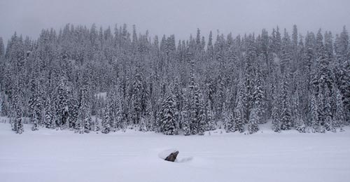
We popped out of the trees on the shore of Skyline Lake. We'd gained about 1,000 feet in a mile and a half and although warm in the few layers we hadn't already stripped off we quickly chilled once we stopped. We stepped under some trees and I broke out the hot chocolate. We pondered our next move and decided not to head along the plotted route under the outlet of the lake, but rather gradually climb out of the bowl on the far side of the lake.
Clearly not our best choice. We struggled up the steep slope, dropping elevation on occasion when necessary, but eventually gained the ridge. When the clouds cleared momentarily we could see we were on the edge of a steep drop off leading down to a tributary of Nason Creek. To regain the plotted route we headed west along the ridgeline, climbing up a knob in the process.
We topped out at about 5,400 feet, but dropped a bit and climbed again. We were stopped by a 20 foot drop. To the north was a steep slope with snow hanging perilously overhead. To the south was a 30 foot deep ravine, but it seemed like we could go back east and cross the ravine lower down so we turned that way.
Our first approach showed that the ravine was indeed getting shallower, but at 20 feet it was still too big a drop. Another try and it was down to 10 feet. Finally we were able to drop only a foot or two and cross to the other side. Unfortunately, the other side was not only blocked, it showed us that there would be no continuation to the west.
We stopped on the edge of a huge boulder garden. Each monster rock was at least 20 feet high. They were piled on and against each other, but the snow obscured what is probably a passable route in summer. Bugger.
On the way back to the lake we stopped under some trees to have lunch and figure out what we wanted to do. Since we were turned back so early we would wind up driving more than we were hiking. Oh well. What can you do? We resigned ourselves to a short trip and returned to the lake.
Under some trees at the end of the lake we met a couple who thanked us for breaking trail up to the lake. They admitted they'd never have found the lake without our track, though I admitted it was really the GPS that got us to the lake.
When we got back to the crossroads we decided to follow the road up rather than down. Once again, Dan was rewarded for his new fitness with the task of breaking trail. The road crested the ridge at a cell tower overlooking a tributary of Stevens Creek.
The snow had stopped a while ago and the clouds were starting to thin. Looking straight up rewarded us with a mostly blue sky and on occasion we could see our own shadows. I tried to convince Dan to head up the hill to a point at 5,447 feet and perhaps out a ridge to the north. However, we wound up heading down the steep hill in the forest intending to parallel the road we came up before picking up the trail lower on the slope.
Under the trees the snow was untouched and mostly powder. When we found an open area we would bound down through the snow just barely in control. Almost every one of these sprints wound us up face down in the snow, but it was well worth it.
After drinking in a gorgeous view across the highway from atop a dangerously steep slope we started traversing back toward the trail we had come up. The sun was setting in the west providing some amazing settings to 'shoe through. We hurried across the last slope in view of the car in order to try to get to the bottom in daylight. (We both had headlamps, but I wanted to try to see our track across the slope before it was too dark.)
The drive home was uneventful, but a little depressing. We could see the boulder-strewn peak that turned us back against a blue sky as we drove down the mountain. I still couldn't see a way through the rocks, but with better conditions we might have been more inclined to try.
In the end we did about 5.4 miles and 2,000 feet of gain. No permits were required, but I did have to buy a shake for Dan and Zeke's.