With the planning all but complete for another stab at the Pacific Crest Trail in August (go here for the 2002 installment) it was time to start training. The original plan called for a two day trip north from Snoqualmie Pass to Spectacle Lake, then east to Cooper Lake where we would have stashed a vehicle.
Nick had to bail to attend a wedding, but remained in the loop enough to suggest we might have problems with snow. Lo and behold, the rangers reported an eight to 10 foot wall of ice and snow blocking the path. We could make the attempt if we had climbing gear, but maybe we ought to look elsewhere.
So we plotted a course up past the Granite Lakes, over the ridge to Thompson Lake, up the western face of Mt. Defiance, down to Mason Lake, and over Pratt Saddle to Lower Tuscohotchie Lake. All that was day one. Day two was an easy downhill exit along the Pratt River to the Gateway Bridge where the truck would be parked. 15 miles on day one with about 6,000 feet of gain, not to mention 3,000 feet of loss. 10 miles on day two, but just about all 1,400 feet of elevation change would be loss.
Saturday dawned rainy with little promise of a drier Sunday. Still, this was training so off we went. The truck was parked, keys double-checked, and soon Dan was leading Paul and I up the trail. Actually Tokul and Emily (Paul's dog) were really leading, but Dan was the head of the human train.
Half way to Granite Lakes the rain really started to pour so we switched into rain gear including a wonderful poncho/halloween costume that Paul wore. It was a cross between a shower curtain and a black rider's outfit, but did keep him pretty dry. We passed by the Granite Lakes and up to the gap and down to Thompson Lake, arriving about 2pm. Miraculously, the wind and rain were blocked by the hills and lunch was dry if not warm. The trail down was brutal, though, and we all thanked our lucky stars we wouldn't have to go back up.
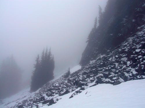
After lunch, about 3pm, we headed up the other side of the Thompson Lake basin and up the shoulder of Mt. Defiance. The mountain is about 5,600 feet tall. Unfortunately, the western approach is rather sheltered and the snow level had recently dropped to 5,000 feet so there was rotting snow beginning at about 4,500 feet.
At the first talus field I crossed using my trekking poles as probes to find the voids and mark a safe trail. In doing so, though, we lost the actual trail up the mountain. The GPS indicated it was above us, but so was a rock wall that we were definitely not climbing or going above. When we looked ahead we could see at least one more large talus field and the likelihood there were more before the summit was high. To make matters worse the weather was deteriorating and we had only four hours of daylight left.
We decided to abandon our original plan for fear we'd be stuck in the snow when it got dark and we weren't terribly thrilled by that prospect. After convincing Tokul that she could indeed go back the way she had come we retreated to Thompson Lake to make camp in the one, cramped, flat space.
We all had fitful nights, mostly thanks to the dogs, but morning came to find everything still damp from the day before. It was my first backpacking experience with rain and it's not all that great. Still, I'd trade a couple of weeks of rainy backpacking for a week like we had on the PCT last year.
After breakfast we recalled the hill we were glad we wouldn't have to go back up. Now, though, we did. Dang. We climbed out of the Thompson Lake basin to be blasted by a cold wind which would be with us for the rest of the day. Soon we found ourselves back on the Granite Creek road which would take us back to the spot we were dropped the previous morning. Of course, the truck was a solid 10 miles up the Middle Fork Road so something was going to need to happen.
That something turned out to be a climb up a nameless hill that topped out at 5,100 feet. With the fog swirling around we didn't get many views, but we did come across what we figure is a winter cabin perched on the hillside just below the summit. The only door was at least 10 feet off the ground and with no available source of water we figured it must be a snowmobiler's paradise.
After getting to the very top and standing on a stump to see if that would aid cell reception we headed down, down, down. We would wind up dropping 4,400 feet all on a dirt road that was at times packed sand and at other times sharp, loose rocks. Ugh.
We did get in contact with the rescue brigade (aka, our wives) who agreed to cut short their day in Seattle to pick us and the truck up. The adventure ended with pizza and blisters at home, but it was quite warm and inhabited by loveable little ones. A good trainer, even if it was a little less than enjoyable. We totaled 19 miles in two days with 6,700 feet of gain and 5,600 feet of loss.
Of course, rain on this trip means a dry PCT in August, right?