We bought the book and the map. We filled up the gas tank, Camelbak, and the diaper bag. We were ready to go. Too bad we didn't know exactly where we were going.
Our first full day in Kentucky was to be a six mile hike in the Red River Gorge east of Lexington in the Daniel Boone National Forest. Although the guy at the gear shop warned us of dangerous elevation gain (800 feet) we were determined to go anyway and found ourselves approaching the turnoff by 10am. Unfortunately, there was no turnoff, just a tunnel.
On the other side of the tunnel we looked at the map and realized the road we wanted to be on ran on the top of the ridge we had just passed through. The best way to get back there was not to go back through the one-lane tunnel (far scarier than the Snoqualmie railroad tunnel, though not nearly as long), but to continue the scenic driving loop we had planned on for after the hike.
The drive wasn't all that great and certainly wasn't worth the hour it took to drive 35 miles. We did wind up where we wanted to be and ready to go by a little after noon and were soon on the trail at a fork with no clue which way to go. My peerless navigation skills directed us to the right (stay on the ridge, always stay on the ridge), but soon we were on the correct trail to the left and making good time.
The trail went through deciduous forest (well, duh, it's all deciduous) before entering a field of wild rhodedendrons - all in bloom. The weather was great, about 65F will some sun, but certainly not the normal 80F weather we were expecting. We emerged into a clearing where the first step was a doozy.
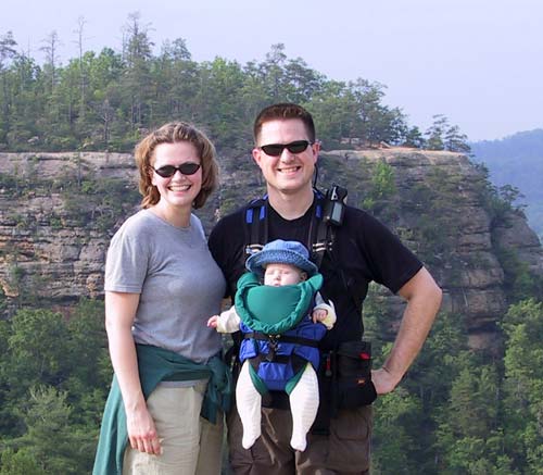
Auxier Ridge, where we now were, drops about 300 feet to the valley (aka "hollow" in Kentuckatonian) floor. The ridge continued with cliffs on both sides and a narrow walkway between the two main areas. It ended at Courthouse Rock, so named because it is as big as an old county courthouse.
We headed down, down into the valley along Auxier Branch (a creek) through the poison ivy and poison oak and probably poison everything else before heading back up to Double Arch.
Arches are big in Kentucky and this one was special because it had an upper and a lower opening. We climbed up and found a nice spot where Clara could get a snack while Amy looked over the valley back at Auxier Ridge. I climbed to the top of the arch where the view was even better.
The rest of this loop was rather boring. A climb out of the valley to the road and then two miles back along it to the parking lot. In the end it was 8.1 miles (according to the GPS), but well worth it.
We headed back across the freeway and into Natural Bridge State Resort Park. We're still not sure what the "Resort" part of that is, but the "Park" part included a 1.7 mile loop up to Natural Bridge which is one of the biggest and best known arches in Kentucky. Time was waning so we ran back down and started our trip back to Louisville without much more adventure.