Uh huh. Good plan.
Amy was heading to school by eight so I got up at 7:30. Later than I wanted to, but sleep is so precious it was hard to roust myself even for a hike. By 9am Clara, Tokul, and I were finally in the truck ready to head out. Until the oil light came on, that is. Bugger. So two quarts later we were finally off.
The day promised to be hot (for the Northwest, anyway, it was in the mid-80s) so I was a little doubtful I'd be able to get to the top in time. I had budgeted two and a half hours to get up and an hour and a half down. I needed to be back by 1pm when Amy would be home.
As I was heading up the road to the trailhead I saw a very large sign that said something to the effect of "if you're looking for a quiet place to be today this isn't the way you want to go." Sadly, that was the way I wanted to go. Turns out the Forest Service had finished the new Bandera Mountain trail and were dedicating it to the late Ira Spring who passed away recently. (Ira Spring wrote most of the hiking books I use.) The trailhead lot was already at capacity when I arrived so I shoehorned the truck into a ditch and got prepped to go. By the time I was ready to roll 10 more cars had shown up.
The trail I wanted is an unofficial trail that diverges from the Bandera trail at the first switchback. A group of slow-movers in front of me looked rather official so I figured I'd just hang back and disappear when the time came. Unfortunately, they were also polite and let me go past them about 10 feet before my junction. I'm sure they probably looked strangely at me as I wandered off into the forest as though I had missed the turn in the trail.
Putrid Pete's trail was tiny compared to the Bandera Mountain trail. It winds through the dark forest for a couple of miles, climbing about 1500 feet before breaking onto the exposed face of Putrid Pete's Peak for the last 1000 feet to the summit. The heavy canopy meant there was little undergrowth except at the dry creek beds which might trickle or even flow well during the wet season, but were only havens of cool air at this time of year.
A little ways in we came to an intersection marked by a cairn. A trail went down to the left (or more sort of straight) while another switched back up to the right. I assume the trail to the left is the connector to the Dirty Harry trail, but didn't pursue it. I took the trail heading up.
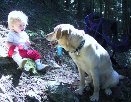
Clara was getting a bit fidgety in her pack so we stopped mid-trail for some snacking. The hill was very steep so I sat her on a rock and paid very close attention. She shared some raisins with Tokul and had some milk. When she started trying to eat the sticks, though, it was time to get back in the pack. Sorry, girly, but sticks are not for chewing. (That's the dog's job.)
After more switchbacks and crossing the dry creek repeatedly there was another junction marked by a cairn. Sadly, I didn't see this one. I went straight on what seemed to be a fine trail. Unfortunately, it petered out. Clearly someone else had made this same mistake for there were clear tracks to follow. By the time the tracks ended at the side of a large talus field I was way beyond the intersection and had no idea where the trail went. At the time, I figured it crossed the talus field, but couldn't see where it entered the forest again.
It was 11:30am and although I was only 1,000 feet short of the summit I knew it would take me a really long time to go that last half a mile without a trail even if I could get out of the forest and onto the exposed slope. Time to call it quits. Dang.
At the bottom of the talus field I was about to head back down to the right, but saw there was a faint trail to the left. Was this where I lost the trail? No, but it was clearly where others had gone in search of it. In fact, the real trail, as well-defined as it had been at the intersection, ran up the far side of the talus field. Good to know for next time (oh, there will be a next time), but not terribly useful now.
I headed back down until I found the cairn and realized how I had taken the wrong turn. I moved a couple of logs to block the "bad" trail and continued down the hill. It took me only an hour to get back to the trailhead which was even more crowded than when I left, if possible. In spite of some 100 cars in the lot, I saw nobody on my trail. They were obviously all there for the well-known Bandera Mountain, Mason Lake, or the dedication.
I figure the hike needs at least five hours of time to finish, but I don't know that Clara's ready for five hours in the pack. It was so much simpler when she was more of a napper and would sleep in the frontpack while I tromped through the woods. Now she waited until we were back in the car to finally take her nap. She didn't even wake up when I got her home and transferred her into bed. At least I got the lawn mowed.