It wasn't worth fighting. Another camper came up to see if he could help, but there was nothing to do but move. I could chalk it up to any number of things, giving him the benefit of the doubt, but as we were leaving we missed the trail back to the lake and were headed to the privy. He said nothing. We backtracked past his camp (while he stood and watched).
We wound up camping on a little patch of grass right where the trail first came to the lake. It killed me to camp there, impacting the grass that was clearly trying to recover, but it was the least of all evils. The kids fell asleep before I could make dinner. I packed up, hid our bear can, and crawled in.
Ace in the hole. Hmph.
Morning erased any negative thoughts from my head. Heart Lake was beautiful, berries were scattered about, and there wasn't a cloud in the sky.
While my oldest slept in I explained to everyone that came by why we were camped on the grass. It was a great way to ask everyone where they were camped and when they were leaving. "Oh, you're in #4? By the little lake? And you're leaving today? Great! Well, um, I don't mean like that." We relocated into the perfect spot and had a lazy morning. (If you want to see some sweet photos, check out hike2photo.com. That's the site of the former occupant of site #4.)
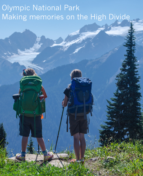
Our plan for the day was to get into the Seven Lakes Basin proper. It was over a little ridge and a couple of miles away. Actually, calling it Seven Lakes Basin is wrong. There are actually 27 distinct lakes and tarns. The ranger that gave us the bear cans at the Eagle Ranger Station showed us a researcher's hand-drawn map identifying each. Just like Henry's middle day, the kids got to run free while I carried a light load.
When we crested the ridge we were rewarded with a spectacular view of Mt. Olympus. I thought it was impressive from Hurricane Ridge a few weeks before, but here it was just across the Hoh River valley. The girls got to see the Blue Glacier, their first glacier that actually looked like a river instead of just a sloping ice field.
The ridge rises and falls as it approaches Bogachiel Peak, the high point of the High Divide. The basin, full of lakes was down to the right. The Hoh Valley was steeply down to the left. We passed a bunch of people hiking the loop as an impressive dayhike and they all remarked on the girls' presence. Still the girls weren't the youngest. We ran into a couple and their 20 month old kid (and grandparents) doing the loop over several days. Talk about impressive.
We made our way down to a lake in the basin and waded in. Whoa. Warm. Well, it was warm in places. Not just where someone might have relieved themselves (don't pretend you don't know what I'm talking about), but in odd spots. By the rock over here and randomly in the middle over there. Unfortunately, our blue skies were clouding up a little so we didn't linger over long. The girls were motivated by an irrational fear it was going to rain on their sleeping bags and the tent without a rain fly.
Like our morning, we had a relaxing evening around camp. I taught the kids some card games and we had an early dinner. There were enormous tadpoles, salamanders, and frogs in the little tarn by our camp so the girls had plenty to do. Lilly had no problem scooping them up while Clara was a little more timid. We never did catch a full-grown frog. (That's probably why they were full-grown.)
Even though we'd been mellow and only hiked about five miles, we were all tired and got to bed at an early hour. Unlike at home, there were no last minute runs to the bathroom, no drinks of water, just burrowing into our down bags and sleeping.
Even Lilly, our perpetual early riser, slept until 8am. Although I was thrilled, this threw off my timing. We didn't leave camp until about 10:30, about an hour and a half after I'd planned. (This will be important later.)
We could hear way too much laughter coming from the lake as we shouldered our packs and started down. A large group of girls were swimming. We thought they might have been Girl Scouts, but actually they were from Wild Whatcom on their "Advanced Backpack Adventure" for girls 12-15. (Oops, I guess my girls are too young for this trip. Don't tell them that.) They looked like they were having a ton of fun and when we saw them later in the day they were tired, but still doing well.
Climbing wasn't a big part of our day, but we did still have to get out of the Heart Lake Basin. Like the day before, it was a slow go, but this time because I was stopping to take pictures. This always happens when I don't know if I'll be back to a place. <click> <click> <click> <click> (I have a problem.)
We didn't hurry, especially with big packs on our backs. Somehow, we found more blueberries, too. Lots more. And good ones. Clara was more a fan of the shiny blues while Lilly and I favored the banana berries. My hands were fairly blue before long.
Mt. Olympus was partially obscured by clouds the day before, but was completely clear on our left. Somehow, I got no good pictures of it. I don't know how that happened and now I know I'll have to go back. (Or maybe I'll find three days to climb it properly.)
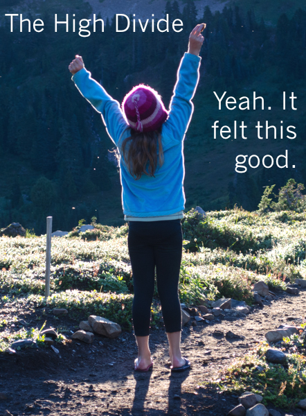
Almost at the summit of Bogachiel Peak, the highpoint on the loop, we found snow. Sweet, cool snow. Others came and went, but we reveled in the glorious white stuff. When we finally did leave a little snowman watched us go.
The High Divide trail doesn't go over the peak itself. However, a signed spur heads up to the site of the old lookout. Blueberries that had grown scarce earlier were suddenly abundant again and provided a nice boost. The views from the top weren't that much different than anywhere along the ridge except we were able to look down into the valley we'd be traversing above for much of the rest of the afternoon.
A herd of elk were tightly grouped in a large clearing. We'd been warned to keep an eye out for them from several of the groups we'd passed. <click> <click> <click> I zoomed in tight. <click> <click> <click> What's that black thing? It's... moving. It was the girls' first bear. And at a far more reasonable distance than Henry's bear last year in Mount Rainier National Park.
From the peak we began what seemed an interminable descent. Much of it was a long, long traverse below the ridge that separated Seven Lakes Basin from Elk Basin. (So named by me.) Blueberries on one side, a steep drop off on the other. (And that bear somewhere down below.) Way off in the distance we could see a trail continue around the ridge, but surely, we were turning more to the right, right?
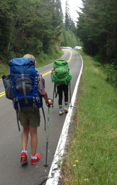
Wrong. The trail kept going with little of great interest beyond a few rock fields Clara dubbed, "her playground." We crossed over the ridge and finally we could see Deer Lake and were soon there. According to the map, Deer Lake was 2.9 miles from Sol Duc Falls, which was 0.8 miles from the trailhead. 3.7 miles, no problem. We'd be out around 7:30pm. Amy texted (yes, score one for Verizon) asking for an ETA. I said we were at Deer Lake and would be out in a few hours.
Big mistake.
The girls were slowing down, though I didn't realize it. Two long days and two nights were finally taking their toll on them. While we'd been averaging about 1.5 mph earlier and sometimes 2 mph downhill, we'd slowed to something a little less than a mile per hour. Plus we had to stop to filter water.
At Sol Duc Falls we donned headlamps for the short walk to the car. Clara and Lilly were dragging so the extra third of a mile on pavement (remember: the parking lot was full) was the final straw. I ran ahead to get the car ready. We changed and were on the road in minutes. A quick stop to drop the bear cans at the ranger station and out to the highway home. It was 9pm.
Even though I'd had great cell coverage on the trail, down on the valley floor there was nothing. While the girls curled up in the back I drove as quickly as I could down the winding road checking my phone every few moments for coverage. I knew I had it when a flood of texts came in.
"Just checking in. ETA?"
"Where are you?"
"Shouldn't you be out by now?"
"I'm calling the rangers at 9:30 if I haven't heard from you!"
9:39pm. Crud. I called home and prevented the call to emergency services. Eric was there reassuring her I wasn't dead (and more importantly, that the girls weren't dead) and that I'd obviously underestimated the time to get out. In fact, Eric's estimate of four hours from Deer Lake was spot on.
I'm now comparing locator beacons to determine which I'll be purchasing before my next big trip. I'm looking at the SPOT Gen3 or Connect as well as the Delorme inReach SE. The big benefit of the inReach is two-way communications while the SPOT is a lot cheaper to buy and operate. (Stay tuned for a decision.)
In spite of the challenges we faced on this trip it was one of our best. The girls exceeded my expectations and handled adversity like I would expect any of my adult adventurer buddies. Most of all, I loved seeing the two of them bonding and helping each other. When one of them was down on the long hikes the other would encourage and keep everyone's spirits up. They are far more effective doing that with each other than I am and it makes them a strong team.
If nothing else, I know that they'll be able to rely on each other on and off the trail and that's more important than everything we saw and did. (Though what we saw and did was pretty awesome, too.)