Since I didn't get to play in Chelan (including the requisite snowshoe outing with Martin) Amy suggested I set something up for Monday. I figured, no problem. Just about everyone got the day off in honor of MLK, right?
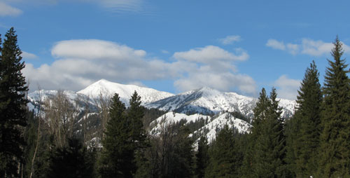
Turns out most of my friends work for companies that are too full of hate to give their employees a day off. (For the record, both the UW (aka, the State) and the Times recognize the holiday.) We tried to work around schedules and plan a late afternoon trip, but in the end it was just me and Josie heading to the Teanaway to snowshoe to its namesake peak. (That'd be Teanaway Butte.) We got a late start, but the drive was half what I had expected so we left the trailhead at 2:30 under mostly blue skies.
There are two routes to Teanaway Butte. One follows the gradually ascending Jungle Creek Road. I would describe this route as the easy route and clearly not worthy of our efforts. The other follows the ridge line above Jungle Creek, passing multiple high points, touching snowmobile roads, and offering a somewhat wild experience. I would describe this as the sucker's route. Needless to say, it is this latter route we chose.
We climbed a road with both snowmobile and ski tracks. Given that the road was churned up pretty well, but also fairly well frozen so we were able to boot up the road without snowshoes for a ways. There was pitifully little snow. Bushes that should be buried under feet of snow were completely exposed. This does not bode well for the summer's water supply. (I think we're at something like 65-80% of our usual snow pack. Not good.)
Originally, we'd thought about climbing over Tarzan Peak, but it was an extra 400 feet of gain for little value. The summit is apparently pretty well treed with limited views. Instead, we traversed to the south of the peak on some fairly steep slopes. Later, we'd refer to this as the Traverse of Terror, though that might be a tad melodramatic. Along the way we had to dodge snow bombs falling from trees, route around patches of brush, and sidehill with so little snow below our snowshoes that it slid away.
The traverse wasn't all terror, though. We found a magic tree that glowed freaky green at the edge of a gully (probably a dumping site for toxic waste. I hear that stuff makes for great fertilizer) and Josie claims an all-white bunny ran across the back of my snowshoes near the end of the traverse. There were tracks, but without photographic evidence it's hard to believe it really happened.
When we rejoined the ridge on the other side of Tarzan we had to drop about 500 feet to a saddle before starting the final 1,100 foot climb to the summit. This is probably where more sensible people would have determined that it was late in the day and our best bet was to climb Tarzan, pretend that was our destination all along, and be back home in time for an early bedtime.
Clearly, that wasn't us. Onward!
Although the ridge was somewhat pretty and open up high it quickly became... um... lame as we dropped. There were lots of downed logs (look out, Josie!) and not enough snow to be fully covered. At the bottom we put on headlamps and started climbing out of the valley. We did not look forward to climbing back up toward Tarzan and dubbed it as the Valley of Crap. This is not melodramatic and actually somewhat toned down from our conversation at the time.
We hadn't had a trail since leaving the road before the Traverse of Terror so we were bushwhacking and breaking trail through the wet, heavy snow. Now that it was dark it was even more fun, as you can no doubt imagine. The moon was out for a bit, just a slice, really, and we could see a few mountains and a touch of the sunset through the trees, but no clear views. Unlike some other trips that offer a steady climb this route was full of ups and downs. None were big, but each was a little traumatizing knowing we'd have to do the reverse on the way back.
As we climbed higher the snow got better. It was drier and fluffier, but probably only because the wind had dumped it there before it had gone all soggy. Even on the final approach to the summit (mostly treeless), the snow was stable.
When we finally did reach the summit it was blowing with gale force winds. (No, I don't really know what that means, but it sounds cool and I hear it all the time on the news.) The wind was so strong that getting warmer layers on was a bit challenging and pictures were difficult at best. It had taken five and a half hours to get to the summit about five and a half miles from the car. Not exactly the best time ever, but my excuse is that since TNAB ended and the only gym close to my building wants a monthly fee about what I was paying for almost six months at 24 Hour Fitness I haven't exactly been well exercised. MAAD trips like this help, but only so much.
On the subject of pictures, it's really too bad it was so dark. What we could see made us think that the views would have been spectacular. Earlier we'd had some minor views of the Teanaway Peaks, but this would have been so much more. Just on the other side of the hill the snow fell away in dramatic cliffs, but flash photography didn't do it justice and there wasn't even enough light for a long-exposure. (Of course, history tells us that long-exposure photos don't mesh well with high winds, but had there been any light I would have given it a shot.) We also noted that there were few pictures taken of the named features on the trip. While traversing in terror or valleying in... uh... crap we really didn't stop to shoot pics.
We hadn't had service since before we left the car so we called the spouses to let them know we'd be a wee bit later than we expected, but that there were no safety issues. (By "wee bit" I mean "about three hours.") We dropped off the summit to shelter in some trees and eat. We had thought about taking the Jungle Creek Road route out, but (a) that was the chump's route and (b) going back a way you didn't come in in the dark with no cell coverage and a timeline ain't exactly wise. So we resigned ourselves to another visit to the Valley of Crap and the Traverse of Terror.
We were much faster on the way out even though we were both feeling the results of our efforts. It took a solid half an hour of rest-stepping to climb out of the valley, but surprisingly little time to traverse. The biggest problem was that whoever was leading (no names, but it wasn't Josie) didn't think about switchbacking down. Afterall, who needs switchbacks when you're going down?
"Yay, though I walk through the Valley of Crap I know no fear for my boots are Gore-Tex and my snowshoes Atlas." (Except for the fear we each had when we spotted the "Stump that looked exactly like a charging bear except frozen in time." At least it got our adrenaline pumping.)
Just as we were happified by the end to the hard parts of our return it started to rain. With a change of gear we were again set and made good time back to the car arriving just before midnight and getting home at 1am to find Amy was still up and baking.
Our total distance was about 10.5 miles with just over 3,800 feet of gain. The biggest problem is I'm going to want to go back to see the views. Luckily, you can apparently drive almost to the summit in the summer so I think that's how I'll do it next time. Though it would make for a killer winter camp spot...
Bonus: Teanaway Butte is #94 in the Back Court 100. That means I'm 8% complete! (No, I'm not trying to finish that list. That'd be crazy.)