Those poor suckers that help guide TNAB through the season were looking for another trip. I haven't been on Denny Mountain (aka: the Alpental mountain) since the beginning of the nightshoe season in 2007. At that time Jeremy and I only made it as far as the saddle at the top of the first big lift.
("Lift?" Alpental is one of the Snoqualmie Pass ski areas. That's where people who are too lazy to climb the mountain themselves get a ride up.)
Since nobody we knew was able to provide a first-hand account of the route to the top of Denny (another 1,000+ feet from the saddle) we figured it was up to us to give it a whirl. Of course, when looking at the forecast before the trip it was:
Sunday: sunny
Monday: sunny
Tuesday: crappy
Wednesday: sunny
Thursday: sunny
(Can you guess which day we chose to go?)
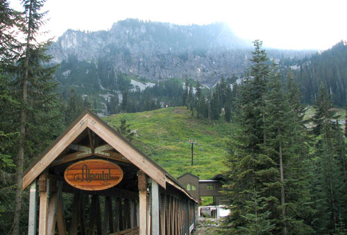
We (me, Scott, Steve, and Tisha) got to the trailhead and were ready to go a little before 6pm. We walked across the fancy covered bridge and through the skiers' plaza to the base of the snow-free slope. There was lots of low brush, but otherwise the way looked clear. We started looking for a way up and soon stumbled on a trail directly under the main lift.
Although really convenient what with a parking lot and a covered bridge there isn't much of a sense of wilderness when you're walking directly under a ski lift. Nonetheless, we made good time up. Snoqualmie Mountain and Guye Peak rose behind us, berries were ripe all around us, and although the brush was wet at least it wasn't actively raining on us.
At the top of the lift we paused to figure the next move. We had a trip report that showed generally how another group had made their way to the summit, but it wasn't clear exactly where they chose to leave the saddle. We found a semi-likely bit of talus and started climbing. (Turns out we didn't go far enough south. Hmph.) The talus petered out and we bashed through head-high brush and clambered over rocks. Eventually the brush gave out and we were on big crumbly slabs.
There was a bowl to our left, a ridge up the middle, and a little draw to the right. The others seemed to have gone up the right so we followed that way, too. Beneath a chair lift pole we found a pile of spent artillery shells that were likely used either to fight off the hordes from the other Snoqualmie ski areas or for avalanche control.
However, that wasn't the only garbage we found. It seems people must be awfully clumsy while riding the lifts. The ground is covered with bits and pieces of their trash. Everything from candy bar wrappers to lousy cameras to beer cans and bottles. So many cans and bottles I wonder if they give a beer to everyone that gets on the lift. The trash really brought us down a bit, which was too bad because the area above the brush was really lovely.
We found a loose gully that had been indicated as the way up and did our best not to kick rocks down on one another. Turns out we're really bad at that. Or at least the dogs are. (We had four dogs with us: Two of Scott's and two of Tisha's. Tokul stayed home on account of the rocks and her recent bath.) One of the rocks actually sparked as it bounded down the slope.
We walked along the cliffy area (with cool skier-falling-off-the-cliff graphic) below the top of the lift and then scurried up the loose rock to the summit block. Thankfully, our predecessors had found there was a crack behind a tree that granted passage to the summit itself. We dropped our packs, hoisted the dogs, and wriggled through. In Mammoth Caves National Park there's a passage called "Fat Man's Misery." This was narrower, but not as dark and not as long. It did have a 90 degree turn, though.
On the other side we had a bit more rock, a last few dog-lifts and we were on top. Mostly. There were three rocks that each might have been the true summit. We think the one by the tower is the actual summit, but to be sure we tagged them all. (Well, at least I did. Scott and Tisha both stopped at the likely suspect and Steve got that one and the next most likely.)
Without most of our gear we didn't stay long as it was a bit chilly. Just enough to get a few sunset pics and head down. Of course, then we had to come back up to take the summit shot, then we could head down.
When we left the last of the open rock and entered the brush again things got... interesting. It was dark by this time and we were following headlamps, intuition, and GPS tracks. None of them served us kindly. Steve did, however, and we were able to get back to the saddle via a far better route than I had led us up through the brush.
Sadly, our good luck didn't persist and we wound up off the trail down to the parking lot and instead were in a nasty little gully full of rotting logs, huckleberries (yum! except the ones that tasted like poop), slide alder, and at least three kinds of spiky plants. The brush was so thick the dogs were unable to push through it and had to resort to actually going around or over. Oh the caninity!
By the time we got back on track Scott and I (the dimwits without pants or tall gaiters on) were bleeding a decent amount. I personally demonstrated my mad mountain skillz by slapping myself in the face with a bunch of brush that had grabbed my trekking pole and by doing a face plant ending balanced only on one hand. The fingers on said hand were pretty close to touching my wrist, but the wrong way.
The only problem with the lower section, aside from the periodically disappearing trail, was that the trees the Alpental staff must have cut to ensure a smooth ride for their patrons were left in place. That meant that not only were there tons of mini-stumps perfect for tripping on and stabbing, but the dried out two foot lengths of trees they'd left were nice and sharp, too.
By the time we got to the car we were pretty sure there was no way this was a TNAB trip. The idea of coming down through the brush in the dark was not pleasant. (Time-wise, though, it fit perfectly at about four hours round trip with 30 minutes at the summit.) Heck. We didn't even go to the Pour House afterwards, though that might have been because it wasn't Thursday.
Total distance was about five miles with 2,500 feet of gain.