Bryant Peak is a blast, but it takes a wee bit of skill. Lucky for us, we actually had a non-leader with us this time. Heck, there were actually two of us that had made the trip before so certainly we couldn't experience any problems.
Chris, Scott, and I were the only regulars at the trailhead as we approached our departure time. We met one newbie who got a head start and a semi-regular joined us with two friends who hadn't been to TNAB before. Since the final part of the trip requires off-trail route-finding and scrambling we suggested everyone regroup at Hemlock Pass, several miles up the trail.
A mile in we crossed Denny Creek and were astounded at the damage done by the winter's floods. I know this is a tiresome refrain by now, but each time I see the remanants of a bridge's foundation and the scoured channel of a seemingly tame creek I'm always amazed.
The trail is easy to follow all the way up to Hemlock Pass. Scott set a quick pace and we didn't bother to stop for the usual pictures of either of the waterfalls along the way. We passed a regular who starts early, but is usually content to not actually summit in favor of a more moderate pace. Below the pass we waited for the three who had joined us and I tried a fancy new mosquito repellent that might just displace DEET in my pack.
One of the new hikers had a blister so she and her husband went to Melakwa Lake while the remaining four of us, plus the advance hiker, headed into the woods. We climbed the right talus field (this time), crossed a snowy meadow/swamp, and followed the same route as last year up a steep slope using huckleberry bushes as veggie belays and resting in the bends of trees struggling to stay upright.
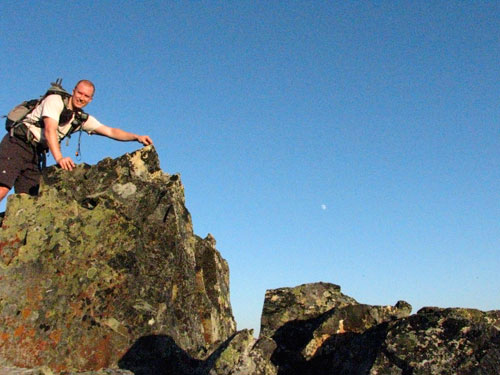
Above the slope we passed by Yet's Rock and started climbing the talus field toward the summit above. Two more regulars had started really early and were on their way down, but we conned them into returned to the summit for group shots. I donned my helmet mostly because I had it with me and because if I got hurt without the helmet on I'd never live it down.
Just below the summit, while clinging to rock, my phone rang. There was no chance I was going to answer it there and in fact I was surprised it got a signal at all. On top I tried to return the call, but there was no signal. I still can't explain while gaining an additional 20 feet lost my signal. Only two more months and we're done with T-Mobile!
From the summit we were treated to spectacular views on a nearly cloudless evening. The bugs weren't bad and we could see from Mt. Baker to Mt. Rainier with ease. We played name-that-peak for a while, but then headed down knowing it was a long hike out. (This is one of the longest trips TNAB does all year.)
Just below the summit, where we had convinced the early summitteers to turn back toward the top, we ran into another group of three TNAB hikers. We weren't as pliable and continued down while they tagged the summit. We made it back to the trail before dark and began the long hike out. The moon came out, but didn't really light up the terrain so headlamps were all the rage.
I skipped the PostNAB at the Pour House because the next day was Lilly's first backpack and I wanted to be fresh or at least remotely rested.
Total distance was about 8.6 miles and 3,500 feet of gain.