Clara started her backpacking career at age four at Scout Lake. I'd been there once before and then returned with Daryl to find a good camp site before we took Clara and Daryl's son, Lex.
The next year Clara and Lex overnighted at Margaret Lake with a similar scouting mission, though this time with Josie, not Daryl.
So now that it's time for Lilly to get in on the action it seemed only natural that I check out the spot that seemed so great in pictures and trip reports, right?
I had planned to go by myself, but at the last moment Daryl found he was free to come along. We left the west side early Saturday morning for the two hour drive to the end of the North Fork Teanaway Road.
As you can imagine, a two hour drive better be well rewarded and as we got out of the car it looked like it was going to be. Blue skies without a hint of clouds. There were a bunch of cars in the lot even at 7:30am, but we figured most had to be overnighters since you'd have to be crazy to be up early enough to beat us.
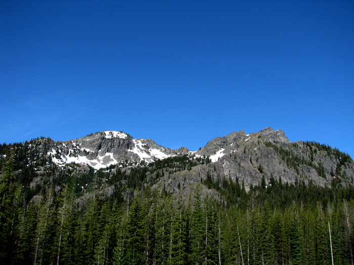
The Esmerelda Basin trail climbed leisurely through a sparse forest and the occasional meadow. Avalanche lilies and Jeffery's shooting stars colored the bright green yellow and purple while the dramatic faces of Esmerelda Peak and Hawkins Mountain lined the south exposure. The north rose more sedately, but just as high culminating in the ridge between Iron Peak and South Ingalls Peak.
I had read about "established camp sites" so we kept our eyes open as we made good time up the trail. There was an abundance of water flowing down to join the North Fork of the Teanaway River at the bottom of the valley. One of my fears was that this would be a dry basin and we'd have trouble getting water. No problem here.
At about a mile in we found a tent parked nearly in the middle of the trail. Actually, it was the middle of the trail, but it was the old trail. The new trail switched away from the tent and its slumbering inhabitants so we stealthily passed by. At about two miles we found the camp sites that had been written up. They looked great so we knew we had a winner. Of course, two miles is about an hour even at a very easy pace so we had tons more time. We continued up solely to look for a better site just around the next corner. (Yeah, that's why we kept going...)
The forest opened up as we climbed just a little higher and we were treated to unobstructed views to the south. Snow still clung to the steep, northern faces and although we didn't see any goats (DARN!) I could imagine them being there anyway. Higher, we turned on to the County Line Trail and found whoever maintains the Esmerelda Basin trail (#1394... why does that sound so familiar?) does a much better job than the maintainers of the County Line Trail. Or maybe it was just steeper and more prone to runoff.
Regardless of the reason, it was full of more annoying ankle twisters and exposed roots. When we crested a ridge and found a spring-laden plateau we ran into the first people we'd seen all day. Three women were camped in the only spot we'd seen since leaving the easily accessed sites below. They told us the pass above Lake Ann was just a few minutes up the slope so we pushed on. I had plotted a route up to the pass and then to a local high point, but looking at it in real life made me reconsider. It was far more rugged a route than I had counted on.
At the pass we could look down into Lake Ann's basin, still covered with snow, and up to the west sides of Ingalls, South Ingalls, and Fortune Peaks. (Interestingly, we saw very few larches in Esmerelda Basin, but Lake Ann's basin appeared full of them.) We broke out some food, even though it was barely 10:30, and found a pile of rocks to relax near. I tried to goad Daryl into climbing South Ingalls, but he was having none of it.
We did decide that it should take no more than an hour to get up and that he was find staying at the pass while I raced to the top. As I left I told him two whistle blows meant come get me. I was serious. I think he was thinking two whistle blows meant he should head back to the car.
As expected, there's a faint boot path up the ridge from the pass. I had to dodge through some rocks to avoid a fading snow patch, but otherwise it was a pretty quick and easy climb through the scree and hard packed rock. It took only 20 minutes to gain the 1,000 feet and get a killer view.
The views to the South and West weren't much different, but looking to the north and east I was treated to spectacular vistas. Ingalls Lake was just showing a touch of blue around the edges and the Headlight Basin was solidly locked in snow. Mt. Stuart raked the sky with its jagged series of peaks and tiny Lake Camp Fire Girls was just peaking out from under a blanket of snow along the ridge. It's probably good Daryl didn't climb with me or we definitely would have descended into the wintery basin for the trip back to the car. (You can make a loop on established trails if you can find them.)
As it was I lounged in the bright sun taking pictures and looking, in vain, for the summit register. Not wanting to leave Daryl baking down at the saddle I made quick work of the descent almost plunge-stepping down the scree. I found a couple of other parties at the pass and learned that at least one other party had been camping down in the Lake Ann basin and had already climbed up and out. (From the pass it wasn't clear how to get down to Lake Ann, but from the peak I could clearly see the trail.)
We headed down dodging sweat bees determined to ruin my pictures and the odd black fly. There were no mosquitos to speak of. Back on the firewire trail (ha!) we started seeing more and more people. They were mostly in larger groups and all seemed prepared for the heat and sun. Apparently, I wasn't, though, as I wound up with a wicked sunburn that overlapped the sunburn from the previous weekend.
Down at the camp sites we explored around and found the one we really really wanted. There were at least four or five others that would do if it was taken, but we spent the rest of the hike out thinking about how we could guarantee we'd have it.
(Daddy #1 could race up to the site from the trailhead, claim it, and then return to hike the rest of the way with the kids... nah. Daddy #2 could leave the west side before dark, hike to the camp site, set up, and then hike up from the trailhead with the kids... nah. Daddy #1 could come up the night before, claim the site, drive home, and then come up with everyone else... well, maybe, but... nah.)
In the end we decided we wouldn't push it too hard. Even though our camping weekend was July 3-4 we'd only leave at an acceptable time (8am) and mosey up the trail. Worst case scenario would be someone passing us as we made the final turn, but someone that fast wasn't likely to stop there anyway. Fingers crossed we headed down and back to the car.
We even scouted the ice cream selection at the Teanaway Mercantile. It was deemed delicious... um... I mean sufficient.
Totals for this only-for-the-kids trip: 10 miles and 3,000 feet of gain to the summit of South Ingalls Peak.