I threw out an invitation to neighbors and online friends: Buy a permit for the Snoqualmie Tree Farm and I'll drive and show you some cool things I've glimpsed with the kids. I've done more exploring and hiking this year than I have in years past and have identified a bunch of places I want to get to.
Unfortunately, there were no takers. Most serious hikers consider logged forests to be places undeserving of a hiker's boots. Most fisherman aren't into climbing mountains just to see what the view is from the top. So that left me. Just me.
And I had to be back by noon. Yikes.
So I got up at the time I would normally to go to work. Groggy and wondering why this seemed a good idea the previous night I stumbled through the routine of making coffee and got on the road by 5:15am. The coffee was gone by the time I got off the pavement, but I was a full hour more on Hancock's roads as I drove up drainages of three different rivers. The Mainline road, a near gravel highway when I got on it, dwindled to a standard dirt road with room for two cars to squeeze past each other if necessary.
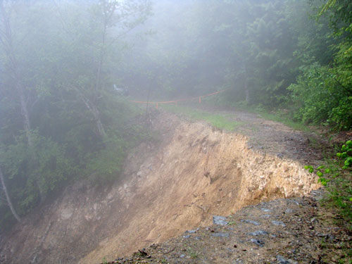
As I climbed up switchbacks through relatively recent clearcuts the fog was so thick I had to use my wipers and visibility dropped to near zero. Happily, it opened up so I could see at least a 100 feet when I saw a big branch and an orange ribbon strung across the road. Just beyond the road disappeared into a massive slide. The river was a LONG way below us, but unless there was just a big hole that opened in the earth this gouge was huge.
I was well below where I had hoped I'd be able to drive, but I did some math and figured I could still make good enough time to give me a realistic shot at my primary destination or at least my backup.
My primary was a lake for which I could find no references online. That's rare. The backup was to climb the ridgeline and see if I could join into a three-peak circuit usually accessed from the north off Highway 2. (I was just a couple of miles from the other main east-west highway.)
The road walk was going swimmingly (though it wasn't actually raining) when I found a talus field that looked like I could shortcut a long looping switchback on the road. Awesome! Up I went and found at the top there was no connection with the road. GPS told me where I had to bushwhack, but it was beastly through slide alder. Each tree I touched rained on me and soon I was soaked worse than if it had been raining from the sky. I did find some of my favorite flower, the bunchberry, but that was a pretty weak consolation.
When I did get back on the road I was soon presented with another talus opportunity. Learning from the last experience I marked it on the GPS and followed the road. It again looped long and far and when I was directly above my mark on the GPS I could see a potential way through the talus to connect. This time I should have taken the shortcut. Oh well.
At 3,600 feet I stopped and had some food, looked at the maps, and determined I'd be crazy to get to the lake. There was a fair amount of snow anywhere the sun didn't have direct access. The lake basin was sure to be full of snow making it both difficult and dangerous to go there by myself.
Instead I decided to climb the ridge above the lake. Perhaps the fog would clear and I'd get a view of the lake or down the other side of the ridge. Either way, it would get me some elevation and route-finding like that is always fun.
I stayed on talus where I could, or snow, or snow covering talus. The latter was a bit dicey at times as postholing in just the wrong spot could put me up to my hips in snow, but by using my poles to scout the way I had no problems. I was blocked from the ridge over the lake by steep cliffs and since I couldn't see how far they extended I followed a weakness in their line that headed back west. In theory this would put me at the westernmost highpoint of the ridge.
When I got to the ridge I saw the north-facing slope on the other side was still locked in snow. (The south side, with more sunlight, was mostly snow free except in local basins and where it was heavily shaded.) I found a highpoint, but the map indicated there was another just to the west. That one was also a falsie as was the next one. I was dispirited, but realized the last highpoint would be the true "summit" and my trek would be over. I arrived there at 8:18am. (Far too early to summit unless you got an alpine start.)
I was surprised to find a geocache that gave the point its name, "Persis View," but not surprised it hadn't been frequently visited. In fact, since being placed in 2003 it had only two parties sign the register. Both were in 2008. I took a self-portrait with the disposable camera in the box, signed in, ate some bar (from my pack not the box), and headed back the way I'd come.
I contemplated running the ridge further east, but remembering the cliffs I'd seen earlier and the drop-dead return time I followed my ascent route closely and got back to the road in 30 minutes. Another 30 minutes and I was at the car. (No, I didn't try to shortcut the upper loop by descending over the talus. Climbing the rocks is one thing. Dropping on them is another and to be avoided if unnecessary.)
In the three hours I'd been away from the car (1.5 hours up, half an hour on the summit, and hour down) I'd traveled only 4.2 miles and climbed only 1,860 feet.
On the drive out (about 30 miles on dirt roads) I saw a familiar and unwelcome light on the dashboard. Tire pressure was dropping in the back left tire. The same spot (though definitely not the same tire) I had shredded a tire on the road to Lake Dorothy last year. This time it was a slow leak (and one that could be repaired!) so I drove on it for a short while until I could find a good spot to change it. Sadly, I'm getting good a swapping tires.
I found out later that if I had followed the ridge and wound up at the more popular summits to the east I would likely have run into a couple of TNAB hikers who were also out there. Good thing I didn't try, though, they said the snow conditions were a little iffy and they wound up bailing due to the slow going and low visibility.
There's always next time...