It's 12:30pm on Friday afternoon and my neighbor Jeremy says he's leaving the house. Um... I really shouldn't leave until 2pm. No problem, he's got some stops before then. Nonetheless I got all but ready to bail and waited eagerly for him to arrive.
The plan was for three days of hiking in the Olympics. It wasn't our first choice. That was on fire. Mt. Adams had been on the calendar for months, but just a few weeks before we were to head south a fire closed the climbing route so we had to change plans.
Luckily, nobody else was foolish enough to try to camp where we were going to camp so getting backcountry permits weren't a problem as long as we could get to Port Angeles by 7pm when the ranger station closed. No problem... we're leaving at 2pm. We should be on the trail by 7pm without fail!
Yeah. Except it turns out the ferry system is woefully under capacity on the weekends. As a result we added two hours to our commute just waiting for our chance to fork over $35 for a round trip. (Ouch!) It could have been worse, though. The guy two in front of us accused us (falsely) of cutting in line and for the next hour or so I fretted he was going to get us kicked out of line. (He must have forgotten by the time we got to where such vigilantism might have been possible.)
At 6:30 we finally rolled into the Wilderness Information Center right behind a woman who needed 19 bear cans for a hike with kids on the beach. Ugh. And the permits were wrong. Ugh. Repeatedly. Ugh. At almost 7pm we finally got our permits and a single bear can and were on our way.
(A bear can, you say? What's a bear can? If you think of a little beer keg made of plastic that you can put your food in so the bear can bat it around, but not open it then you've got the basic concept except you're probably not thinking of the extra weight on my shoulders for the next three days.)
So by 8pm we were finally ready to start hiking from the Deer Park trailhead. I knocked on the door of the ranger since the sign said that's what I should do, but the Crazy Professor (his description, not mine) named Jim said it wasn't necessary. Nonetheless, we chatted for a few minutes as he told us he was just about to lock up and enjoy an adult beverage. Oh, where are you going, by the way? Roaring Winds? Well, get going! You've got a couple of good uphills before you get there. Go! Go!
So we went.
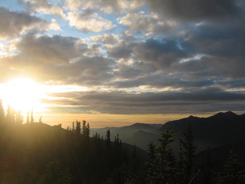
From Deer Park the trail follows a wooded ridge down to a saddle (losing about 700 feet) before climbing back onto Grand Ridge (gaining 1,500 feet) over the course of about four miles. The first section was in dark (and getting darker) woods with no views to speak of. We saw a rabbit and bunches of flowers, but nothing more interesting. As the sun set we entered into broken meadows with occasional views to the Strait of Juan de Fuca to the north and the heart of the Olympics to the south. By the time we were on the open slopes of Grand Ridge it was dark enough to justify headlamps absent a moon. We did see a buck atop the ridge, but could hardly make him out against the dark sky.
Two hours after starting we rolled into Roaring Winds. It's a one, maybe two tent campground with no facilities. Since it was 10pm and there were no views we quickly set up the tent and climbed in to our bags. We had taken Jeremy's two-man tent rather than his or my bigger three-man tents because we were hoping to save on weight. This mean it'd be a tight fit for both of us to be in there and all our gear would have to stay outside. "Tight" was a bit generous. Jeremy described it as "Snugglefest." No matter, I was asleep as soon as I lay down, much to Jeremy's displeasure since he claims I snore, but I'm not sure I believe him.
At about 6am we woke to a mostly gray sky. We had an ambitious day ahead of us so we fueled up with "eggs and bacon" (according to the label on the bag), hot chocolate, and coffee before leaving Roaring Winds.
From our spot on Grand Ridge we'd follow it all the way to its intersection with Lillian Ridge at Obstruction Point. Along the way we saw very few trees, a bunch of deer, grouse (an entire family unit including flightless chicks), and huge mounds of shale. In fact, it seemed as though the entire mountain was made of shale, but in places there was a touch of dirt sprinkled on top to hide it.
A few miles in it started to rain. Just a mist at first, then harder, and finally a true downpour. We put on rain gear just in time for the rain to stop and make us hot. (This will be a recurring theme so much so Jeremy accused my jacket of being in control of the weather like it was koala or something.) We passed the Badger Valley trail down into Grand Valley that we'd likely return on and arrived at Obstruction Point to the unwelcome site of a bunch of cars in the parking lot.
It wasn't a big surprise, but still an annoyance. We'd only started at Deer Park because the Obstruction Point road was closed when I was hastily planning the trip and making the trek from Deer Park to the bottom of the valley was too far for an evening hike. We could have parked at Obstruction Point, but then would have had to backtrack to Roaring Winds or camped outside an official camp site. Oh well. Sucks to be a law abiding citizen.
We'd been trending mostly west along Grand Ridge and now we needed to head more south along Lillian Ridge (named for Lilly, of course). This meant we'd go over a series of small peaks with no access to water. There were small lakes on both sides of the ridge, but it was unknown whether they'd be ice free or if there'd be a way from the trail down to them. As a last resort we'd melt snow for water along the way.
Although the weather was lousy we were in a really beautiful spot. The ridge extended into the clouds ahead and behind us and dropped off on either side into swirling white. The trail was mostly straight ahead along the ridge with occasional patches of snow and flanked by flowers. We had met one hiker at the Deer Park trailhead the day before and one other ("Stoner Dude") before Roaring Winds, but hadn't seen anyone since. We met our first hiker of the day returning from Moose Lake. He seemed very relaxed and mellow after a solo night in the valley.
After consulting the map we picked a spot and left the trail heading to the west in search of two lakes that were supposed to be just off the trail. Looking down into the fog it looked like they might be there, but it'd be really hard to get to them. They appeared to be far down a steep snow slope. At least there was snow. We both broke out stoves and started cooking. It was my first chance to use my JetBoil (Father's Day gift, Thanks!) and it worked great. I boiled up a liter before remembering that it was nearly impossible to cool a liter in a Nalgene even when burying it in the snow.
Instead of boiling more water we just melted it and used Jeremy's super cool purifier to kill the nasties. It uses a battery and rock salt to make the magic happen. The water tastes vaguely like a pool, but mixed with Nuun or dumped into a Camelbak (with its own "special" taste) it didn't bother me. And it was way faster than anything I could do short of iodine. (Yes, I carry iodine as a last ditch backup purifier.)
As we were finishing making our water the clouds blew away and we realized we were no more than 100 feet above the lakes. We had great views of them now, but didn't feel a need to drop to them without a need for more water.
Besides, we didn't need more adventure. We were about to leave the established trail in search of our next waypoint: Moose Peak.
On nwhikers.net there are a number of traveling summit registers. These are little books in a waterproof container that get placed on a summit and then moved to another by someone else. Pointless? Maybe, but fun. I had picked up the Olympics register from another hiker who had hurt his knee on the retrieval and how could I not put it on Moose Peak?
The not-a-trail started where a sign pointing down the hill reads, "Trail," in spite of the obvious trail extending along the ridge behind it. While the official trail is well maintained and is fine for just hiking the unofficial trail is rougher with patches of scrambling and route finding. We had good directions that led us to an arete and then we had to figure out what to do. (Um... an arete? What? Yeah, we didn't know either, but the directions told us to find it and descend the gully from the low point. Turns out it's fancy talk for "sharp mountain ridge." Dang French.)
As we got closer and closer to Moose Peak the route (note it's no longer a trail because a trail implies there's something to follow) got sketchier and sketchier. The directions were impossible to visualize, but when we'd get to a point we'd look around and suddenly it would make sense. We found the gully we were supposed to descend (though I've since recommended the next gully along the ridge might be better) and dropped into the basin below Moose Peak.
Now we had to choose to climb the screen and snow or continue our descent into Grand Valley. It wasn't much of a decision since the register in my pack was burning for the summit so we followed some month-old footsteps across the snow and kicked steps up through the scree and dirt. One step released a mini-torrent of muddy water so we quickly moved to the side just in case something bigger was lurking just below the surface.
As we gained the ridge leading to the summit we looked back and saw a group of three following our route. They, perhaps wisely, chose the second gully. On the summit Moose Peak we were about as high as we were likely to get for the entire trip. In fact, there were no other peaks that we were expecting to summit for this trip. After Jeremy and I signed the register I found a good spot in the summit cairn and said goodbye.
As we looked over the next part of our route we could see a gentle descent to Low Pass and then the steep drop into the Lillian River valley. From Low Pass we were highly unlikely to find more than a few markers showing the way so we looked long and hard at the terrain, especially once we crossed the Lillian. It looked like a rough go, though we could see lines that if we were able to follow would drop us right into the lower basin of Lake Lillian.
Looking back up the Grand Valley we could see tons of lakes from the big (it's called Grand for a reason) to the tiny (some little tarn that probably dries in summer). Gladys and Moose Lakes looked the most inviting. I was surprised at the density of the trees on the valley floor. For some reason I had a vision of open meadows throughout. Looks like our trip out the next day was going to be mostly in the woods. Oh well. That was a long time from now and we had bigger challenges ahead of us.
Just before we started down I had a moment of doubt and ran over to another high point that looked about the same elevation, but in fact was lower. Call it paranoia, but I'm not about to get to within just a few feet of the summit only to realize later I wasn't really on top.
As we descended to Low Pass I took advantage of the loose shale to high step my way down. Usually, this kind of behavior is only suitable in snow where you can almost leap down the hill and expect the ground to give and slide under you with every step. It was quite surreal to do it on rock.
At Low Pass we started trying to decode the next set of directions. We were supposed to find a scratch of a trail (apparently an old CCC trail) that dropped to avoid some talus before crossing a huge talus field in a level traverse. After a bit of searching we found the trail and followed it through the open terrain as it slowly dropped. We found some cairns marking the way that made route finding a little easier, but they ended at the end of the talus field.
As we were standing at the edge of the field trying to determine where we were headed next we heard the crash of rocks tumbling down the steep slope right across our path. The rocks were big enough and fast enough that even a helmet wasn't going to be of much use. (Good thing because neither of us had one.) When the dust had settled we started traversing across aiming for the base of a series of cliffs on the opposite side. (Looking back I could just barely discern a line from the last cairn at the edge of the field leading to the only feature of the field that sort of resembled a rock table.)
At the base of the cliffs we had to push through some small trees and drop down a mild gully. Jeremy got tripped up by an upstart tree and in the fall broke his... buckle. (Come on. He wasn't going to get hurt. That's my job.) Unfortunately, it was the buckle on his waist strap, a key piece of gear. We spent about 20 minutes devising a solution to the problem that involved the broken pieces of the buckle, a bunch of zip ties, and a need for Jeremy to shimmy into and out of his pack for the rest of the trip.
Reassured that Jeremy's hips would bear some of the load we continued traversing under the cliffs finding spots of the trail here and there, but nothing we could really follow. At the bottom of a steep grassy slope (so described in our notes) we dropped several hundred feet through fields of glacier lilies to a pair of muddy tarns surrounded by marmot holes. The marmots harumphed at us as we passed through and a few whistled. They kind of looked like tiny bears.
Below the tarns we found the Lillian River in miniature. Though it was still too wide and fast to jump it was smaller than the creek behind our houses at home. We followed it upstream until we found a spot to cross, then pushed ahead through the brush and bogs. The notes said we should avoid going too low, so we started climbing when we thought we could. This led us to a spot with trees directly in front of us, a deer munching on grass above, and a streak of talus below. We figured the deer must know what's up so we climbed to it, but found no trail. Instead we pushed into the thick woods and found the going very difficult. (The next day we could clearly see we should have taken the talus streak below us. It connected with a talus field that would have placed us in the lower basin.)
After much sweating and swearing and scratching and fighting we rounded the shoulder of the ridge between us and the lower basin. Our goal was in sight, but we'd have to drop elevation to the basin and then climb back out instead of being able to traverse without losing the precious feet we'd already climbed. Disheartened, we started down, but then caught a lucky break.
When we had started the trip I told Jeremy I wanted to see bear and goats, neither of which I'd seen on a hike before. Across the valley we could see a black form moving along the talus. It was a mid-sized black bear more than a mile away, but it was still a bear. Woo hoo!
Energized, we dropped the last bit to the valley floor, crossed a couple of little streams, and started climbing again. The last climb of the day always seems to be the second hardest, right after the first of the morning. This was no different. Although the lake was just over the rise we were struggling to get up the last little bit. Snow, shale, and fatigue combined to slow us to a crawl, but there was no alternative to climbing the last few hundred feet to our campsite.
We crested the ridge to see there was yet another climb ahead of us, but a small one. To the right were a couple of tiny, snow covered tarns just starting to melt out.
Lake Lillian, when we finally arrived, was beautiful in a strange way. Most of the lake was still locked in snow, but the shore was mostly snow-free and covered with a thick carpet of glacier lilies already gone to seed. A single red pod stood alone on the stock and from just the right angle looked like a little heart.
The snow on the lake was jumbled in big blocks and dirty. It likely came from the winter's avalanches on the cliffs surrounding the lake. The only open water was on the other side of the lake, but it was small enough that we decided to stick with the established site in the trees anyway.
Dropping the packs that had been on our backs all day made our next steps seem effortless and almost giddy. We had the tent set up in no time and dinner was cooking shortly after. Somehow dehydrated chili and beef stew is among the best food ever after a long day on the trail. Even pool water has a taste that can't be beaten.
Although I had plotted a route up McCartney Peak that loomed above us neither Jeremy nor I were inclined to try to get up there. It was only a mile and 1,000 feet of gain, but we were done. Even another bear sighting couldn't get us too excited. (It wasn't much closer than the one we saw earlier.) We went to bed by 8:30 hoping for blue skies for our hike out in the morning.
No such luck. At least not at 5:30 when we woke. I wish I could wake up that early without an alarm when its work that I have on the schedule. After a short four mile evening the first night out and a solid 10 miles and almost 3,000 feet of gain yesterday we weren't looking forward to the 15 miles and almost 4,200 feet it was going to take to get back to the car. We decided that we'd rather explore new territory through Grand Valley rather than go back the way we came even though it would be more gained elevation. Our goal was to get to the car by 6:30pm, about the time we had arrived at Lake Lillian.
And we didn't want to fight the brush in the Lillian valley the way we had the previous day. We saw another bear in the lower valley that actually took notice of us and galloped away. Instead of trying to stay high we decided to follow the stream draining the basin down to the Lillian and then climb back to the tarns and retrace our steps from there.
It didn't start well. We were cliffed out as the stream dropped off the edge of the basin over a waterfall. We climbed up a bit and found a way around and then took every opening in the trees to drop. We followed game trails (some were close to being human-quality) and whatever kept us out of the trees. At the Lillian we had to follow it upstream until we found a log jam we could cross on.
Soon we found ourselves below the tarns climbing through open meadows. Bits of blue sky were mixed in with the clouds, but I had little hope it would clear completely. I just wanted to be able to see all the peaks without clouds obscuring the summits.
Now we were on familiar ground and we made great time climbing out of the Lillian Valley. Going up the steep and unstable slopes was much easier than coming down so what seemed a perilous descent was just a matter of muscle power with a touch of finesse thrown in to prevent stepping on the wrong side of a teetering boulder.
As we passed beneath the cliffs where Jeremy's buckle had splintered we heard voices. I looked up and saw three hikers on top of the cliffs. Based solely on the color of one jacket (bright orange) they were probably the three we saw behind us climbing toward Moose Peak. I called out, Hello, and found they were heading to Lake Lillian. "That's where we were last night!" "Did you leave it clean?"
Huh? Really? That might be what you really want to ask, but is it what you should ask? Maybe they'd found the register on Moose Peak and were offended by it (though they left it since it was later picked up and moved to another peak), but come on, couldn't they have asked, "How was it?" before accusing us of making a mess.
At Low Pass we found the trail down to the Grand Valley and watched a group of four slowly climbing through the grass and then rock as they neared the pass. They were significantly more cordial than the previous group we'd seen and they were also heading to Lake Lillian, though they had the benefit of a previous visit and sounded like they knew the route far better than we did. (He claimed it would be better to follow the talus field down rather than across.)
Dropping into Grand Valley our real adventure was at an end. We had plenty of ground to cover still, but it was official trail and the likelihood of getting off-route was very low.
Gladys Lake was cute and small. It curled around a peninsula and appeared to have a bunch of sites for camping.
Just down the valley was Moose Lake and a ton of deer. One of which couldn't be bothered to stand up as we approached. I guess they see a lot of people. We stopped at Moose Lake to fill up with water (we'd been traveling water-light since the morning to cut down on weight) and have lunch. When I return to the Grand Valley it'll be to Moose Lake. The shore is flat and open with great dayhike opportunities in every direction. Maybe Clara will be ready for that trip in 2009 or 2010.
Just beyond Moose we confirmed our decision to follow the Grand Valley out rather than return to the ridges above. While the trail to Lillian Ridge climbed we continued dropping to Grand Lake. It wasn't really so grand. It's much more wooded than Moose Lake with few access points from the main trail (at least to hikers passing by). We saw a couple of guys fishing who reported they'd caught something so maybe it's not all bad news.
The bad news lay beyond Grand Lake as the trail kept dropping and dropping. We passed a couple of streams (complete with log bridge turned about 15 degrees so you really did have to hold on to the handline when crossing) and one nice waterfall (without an access trail, hmph) before coming to the bottom of the world at Badger Creek. (At least I assume it's Badger Creek, it's not labeled on the map, but it's called the Badger Valley.)
Now we were in solid, thick, dark trees. There was a fairly extensive camp set up, but no one was around. We started up the switchbacks with nothing to look at and the only challenge staying focused and avoiding blowdowns that blocked the trail. The trees seemed to go on and on before giving way to broken meadows.
Whenever we were in the open we'd look up to the peaks, but they were generally clouded in. I wanted to see more bears and my elusive goats, but no such luck. When we finally did emerge into a wide meadow we were at the turnoff that led back the Grand Ridge trail. Although the trail was hard to pick out among the blazing flowers it was also starting to rain. I made one last sacrifice and put on raingear to try to get the clouds to move away, but this time they were there to stay.
The trail climbs through meadows with occasional trees and finally a bear! And a close one, too. He was perhaps 20 or 30 feet above the trail a couple hundred feet in front of us. Even though we both had bells on he didn't seem to notice us (or at least care) so we watched as he came closer. I started ringing my bell and he looked up startled, then decided we weren't much of a threat and continued wandering away.
Not long after the bear we were back on the barren slopes of Grand Ridge walking through nearly lifeless rocks and the occasional patch of snow. At a distance we saw a deer, but he was too far away to confirm our observations that all the bucks were in the high country while the does were in the valleys.
When we rejoined the Grand Ridge trail we had about five miles back to the car and it was all about endurance and perseverance. It grew mistier and harder to see distances as we continued with the hope of getting to the car by 6pm. Particularly difficult was the last quarter mile or so that seemed to never end as we wound up around the Crazy Professor's cabin to the car. We arrived at 6:30pm a full 15 miles with 4,000 feet of gain.
After changing into fresh clothes we headed down the twisty road and caught a buck romancing a doe in the road. (Nothing dirty, just courting.) The doe took one look at us and vaulted into the woods over a six foot bank as though she was Clara caught doing something she knew she shouldn't. The buck wasn't quite as quick. He made one try at the bank, slid down, then put a little more effort into and was gone.
Down on the pavement we saw one last deer, a tiny fawn that couldn't have been more than a few days old, but was already fleet of foot enough to spring through the trees to the safety of its mother's side.
After dropping the bear can at the WIC and grabbing dinner for the ride home we sped out of town. We missed the ferry across the Sound by about five cars, but the next came in 30 minutes. I snoozed on the car deck while Jeremy had a little nap upstairs. We got home around midnight.
For a multi-day trip you can bet you get multi-day stats.
Day one: 4.4 miles and 1,475 feet of gain.
Day two: 9.7 miles and 2,700 feet of gain.
Day three: 15 miles and 4.209 feet of gain. (Yes, that nine feet of gain is important. Ugh.)
All told we tallied 29.1 miles and 8,384 feet of gain. More than if we'd actually been able to summit Mt. Adams. I don't know that I'd return to Lake Lillian. The payoff wasn't enough to justify the extra effort, but certainly I'll be back to Moose Peak and Moose Lake. If only there was a Fish Peak and Fish Lake around there somewhere it'd be a perfect trip.