Henry woke up super early again. The last couple of days it had been a chore to get up with him and stumble to Starbucks so the rest of the house could sleep. This morning, however, I was bursting with energy. If he hadn't woken up on schedule I might have considered waking him myself. (No, not really. I'm not that crazy.)
After driving up to one of the Echo Ridge trailheads yesterday I had prepared all the gear so this morning, after Starbucks, we could stretch our legs rather than sit in the truck surfing teh interwebs in the parking lot. The sun was well up, but it was still cool when we parked below Point 4326 on Echo Ridge.
It sure didn't look like much. What do you expect for a "peak" that doesn't even have a name? (Ok, that's not really fair. There are lots of really interesting summits back home without names.) Still, it wasn't an epic hike I was after this morning. I was trying to get the hang of the desert hiking thing. It's a whole different world.
For a hiker from the west side of the mountains every stick is a snake, every blade of grass is covered in blood-thirsty ticks, and the sun will dehydrate you quicker than you can drink down a bottle of water. (For someone familiar with these conditions they think the westsider is a paranoid all hopped up on caffeine driving a minivan masquerading as an SUV. Sounds pretty accurate, actually.)
We had left the bulky Kelty kid carrier at home in favor of the squishable Ergo carrier that Amy prefers. Even though Henry outgrew the frontpack a long time ago I strapped him to my front so I could wear my daypack on the back. I let Tokul out hoping she'd do her business before we started hiking and for once she complied. In a rare moment of brilliance I left her fresh baggie on the bumper rather than putting it in the truck to cook.
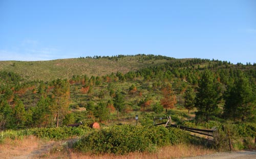
The route is a lollipop route around Point 4326 with a side trail to the summit. The description I'd found (while using the Internet at Starbucks, of course) described the route as having great views, which was good since the views right around you weren't really worth looking at. (They said it, not me.) It sounded delightful (um... yeah), but probably better when covered in snow. Nonetheless, we headed up along the abandoned road.
For the first few hundred yards I tried to avoid the tall grass. I'm not familiar with ticks, but my recollection is they're not fun. However, there was tall grass everywhere and it wasn't practical to stay out of it. Instead, I made sure Henry was well away from it and hoped the little buggers wouldn't crawl up me to get to him.
We went right (following the sign) at the base of the lollipop. The route took us around counterclockwise and had us marching directly into the rising sun. We flushed a grouse (that scared the hair off of Tokul), but generally had little other excitement. The views were long, but not that spectacular. Lots of low hills extending to the horizon. A very different experience than what we're used to. Back home there's always a tall ridge or jagged peak tearing at the skyline.
We entered some taller trees and the road/trail got a little more overgrown, but hardly felt like we were gaining any elevation at all. Around the northwest side we could see up to the next high point, but it wasn't that much more interesting than where we were.
In fact, it didn't get interesting until we found the summit trail. Up to this point we'd been following an old road. The summit trail was a real trail. Far narrower and less level. Of course, I got all spooked by the prospect of snakes on this trail (jumping out without warning, of course), but Tokul was ahead of us and surely she'd know what a poisonous snake looked like, right? Thankfully, we saw none, but I think I'll buy a snake-bite kit for my pack this year.
The trail wove through rock outcroppings through big dusty patches to the very mellow summit. It was actually difficult to figure where the summit actually was because there was little more than a few rocks to mark it. Never mind that, though, we were victorious! Henry had some celebratory snack and I drank some water. Amy called to tell us that the house was up (except Uncle Boppi, of course) so it was good timing. Tokul and I sped down the trail to the road and rejoined the loop.
This southern part of the road was better than the northern half. It was closer to a trail and had views down to Lake Chelan. The flowers were a little fresher here, though still probably a few weeks past their prime. When we got back to the stick of the lollipop it felt like we should be back at the car, but still had a short ways to go. Henry was getting fussy so I popped a bottle into him while we walked.
At the car I did a quick check of myself and Tokul for ticks, but didn't find any. No snake bites, either. Henry was content to sit back in his seat and Tokul crashed in the dirt. She'd been drinking all along and wasn't interested in a bowl of the last water so I felt I'd done right by her and not dehydrated her too much.
Looking back at the trip I'd tell people to pass on it. There are (supposedly) many better hikes in the area and unless the area is blanketed in snow it's just not that interesting. If you do want to go, though, go left instead of right at the stick intersection, follow the trail to the summit, and return the same way. It's a little shorter than doing the full loop, but you get all the goodness.
Our totals were 5.8 miles and about 800 feet of gain.