Thanks to a lot of hard work the new Sperling deck was all but complete by Saturday night. In fact, Amy and I had worked through a thunder storm to wrap up one of the last details. Sunday was all about the 60th Anniversary party that we'd really come down for and that left Memorial Day itself for a short hike.
I conned Chris (husband of Amy's cousin Shannon so that makes him my... uh... whatever) into going with me in spite of the lousy forecast. In fact, when he arrived at Gram's and Gramp's place it was raining with no respite in view.
We drove east about 30 miles to Cascade Locks and jumped on the PCT to cross the Columbia. (The "trail" crosses the river on the Bridge of the Gods, which even has a PCT sign on it just in case hikers get confused.) Another 12 miles east and we were at the Dog Mountain trailhead.
The info I had said you should get there early or you might not get a spot in the parking lot. Hm... must be a small space. Maybe there'd be room for a couple of cars... or a couple hundred. Apparently Dog Mountain is kind of like the Mt. Si of the Gorge. Along with many of our closest friends we geared up and headed up the trail.
Instead of following the Dog Mountain trail we opted for the Augspurger Mountain trail that is often used to make a loop out of Dog Mountain. The guide book indicated going up this trail instead of the main trail was preferable so that's the way we went.
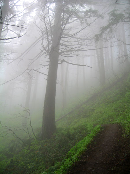
The grade alternated from mellow to steep, but never so steep as to be uncomfortable. We made good time climbing as the trail passed from drier, more open slopes to thicker, damper forest. Down low (below 1,000 feet) it was warm with some sun. As we got higher the clouds filled the woods with mist. When we stopped Chris said the trees looked like they were coming toward him. On the steeper slopes that were open I found that if I looked into the mist without a good reference point I'd get a little dizzy.
We had seen a few runners on their way down, but none of the hordes we had expected from the full parking lot. Once we gained the ridge the trail became very wet and full of mud. The few people we met talked about how we were in for a real treat on the way down on the other trail. This side might be wet, but the other side was supposed to be steeper and a real disaster.
Before we got there, though, we had the final upper section of the mountain that was open and full of wildflowers in bloom. Balsamroot (big, yellow flowers) dominated, but there were sections of red Indian Paintbrush, purple phlox, and even some chocolate lilies near the summit. And those were only the ones I could identify.
Unfortunately, the blowing mist made it difficult to really appreciate the flowers or the views. Supposedly, you'd be able to see Mt. Hood to the south and both Mt. St. Helens and Mt. Adams to the north. We could see no more than 30 feet and toward the end of that it was limited to ghostly shapes.
At the summit there were a few small clusters of people huddled together eating lunch. We ate quickly and headed down the way most everyone else had come up. We had climbed through only a small section of flower fields on the way to the summit, but as we descended we crossed through a much longer stretch of flowers before entering the forest again.
Back in the trees we found the mud, but it seemed less evil than it was described. There was some mud and one slippery bit, but nothing terrible. I can see how it might be a lot harder trying to go up, though.
We took the longer route down mostly because someone said there was a good viewpoint. We did indeed get a cool and mostly sunny view west up the Columbia that we couldn't see from up higher. From there we could see the clouds coming and going over the summit ridge, but declared that the actual summit was socked in the whole time.
The final descent was quick and easy. Through one spot it felt like the Cinque Terre trail through the olive groves in Italy on account of the narrow rocky tread and the stunted oak trees. Mostly, though, it was that weird Gorge forest with brown moss covered talus and a mix of deciduous and coniferous trees, though none prolific enough to claim it completely.
Somehow I had managed to develop healthy blisters on both heels somewhere along the way (though why here and not on Mailbox just a week or so earlier...) so that was unhappy, but otherwise it was a good trip.
I think perhaps next year Clara will be ready to get up there and if we find ourselves in Portland when the flowers are blooming and the weather is good we'll definitely give it a go. And without a doubt we'll head up the same way we did this time rather than the traditional Dog Mountain trail.
Total distance was right about seven miles with just over 2,800 feet of gain.