My fascination with the volcanoes of the Cascades has continued unrelenting. Of the 20 peaks on the list, I've summited 10. My goal remains to summit all of them by 2023. That means I better be climbing pretty regularly, right? Right.
After last summer's twopeaks in Oregon I was thinking about which would be next. When Twitter let slip plans for a climb of Shasta I stuck my digital foot in the door to make sure it didn't close.
I flew to Sacramento Thursday night and drove north. For ever. It's 224 miles, but felt much longer. I rolled into the town of Mt. Shasta around 10:30pm. I knew I needed to get permits so I swung by the ranger station. It was closed, of course, but I was able to discover I needed cash for my summit pass. I found about the only ATM in town and returned to register for the climb. By the time I made it to the Bunny Flat trailhead it was 11pm. The plan was to crash in the car and be ready to go at first light. Note to self: A Ford Fusion is too small for a normal sized guy to sleep in comfortably.
Still, by 7am I was ready to roll. So was the team: Amy. Josh. Jeff.
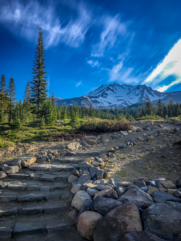
The first few miles of the trail wound through the forest to Horse Camp. It's a beautiful shelter, the camp sites are wonderful, the bathroom was clean, and the caretaker was friendly and generous with his time. But the water. Oh, my. Water so clean and refreshing it ranks right up there with the best I've had. And it just comes right out of the ground with no filtering necessary. Like magic.
The adventure changed from a hike to a climb after Horse Camp. We left the trees behind and followed "Olbermann's Causeway." The first caretaker of the shelter built the trail of raised rocks and although it cuts down on erosion it was harder to hop the rocks than walk on a trail. (And on the way down... ugh.) Beyond the Causeway was the first steep climb on loose rock. At the top of that first hill was 50/50 Flat where some camped, but we continued another 1,000 feet higher to Lake Helen just about 10,000 feet.
Adventuring at elevation is hard. Since I live below 1,000 feet I skipped a hotel in the town of Mt. Shasta and slept at the trailhead to try to acclimate at 7,000 feet. It didn't work all that well. By the time we reached camp I was dead tired, had no appetite, and a mild headache. Walking to the bathroom was easy, but coming back up the tiny slope left me breathing harder than it should.
We set up our camps in existing excavations in the snow. There was room for a couple dozen sites forming a mini tent city on the small plateau. The others set up tents, but I opted for a more minimalist approach. I brought my bivy sack and a tarp, but no actual tent. It was a big step up from my use of a bivy sack on Glacier Peak. I climbed into the shade under the tarp and snoozed through the hottest parts of the afternoon before melting snow. (Yes, we were camped at "Lake Helen," but there was no open water to be found.)
At 2am alarms all over the camp were going off. Shasta's not such a long climb we needed a midnight start, but early morning was certainly important given the daily freeze/melt cycle. By 3:30 we were ready to start our climb.
The first leg of the climb is 2,000 feet in a little more than a mile up Avalanche Gulch. Like many big mountains, it's not terribly exciting. In fact, it's best described as a "slog." Of course, at 10,000 feet a slog is still rather difficult. Step, step, rest. Step, step, rest. Rest. Rest. Curse. Step, step, rest.
Somewhere along the way the sun rose on the opposite side of the mountain. We were denied the warming rays that had reinvigorated me on Mount Rainier, but we were treated to a spectacular shadow cast to the west. As the light grew we could see we were nearing the next landmark: the Red Banks.
The Red Banks are a set of cliffs at the top of Avalanche Gulch. Although there are several chimneys that can be used to pass through, most stay to climber's right and use a gap between the Banks and Thumb Rock. It was the first level ground since leaving camp several hours before and with the sun shining it was a wonderful place to rest for the second half of the climb. Especially since the next section was called, "Misery Hill."
That's right. In order to encourage climbers to keep pushing the steep slope above the Red Banks is called, "Misery Hill." Thanks a lot, place-namers.
Actually, it wasn't that bad. It was more slogging. At least it was in the bright sunlight. Near the top of Misery Hill there were climbers huddling just below the ridge. The wind was mercilessly screaming across the gap between where we were and the summit plateau. We saw some head out to cross and turn back.
When it was our turn we leaned into the wind and slowly made our way across. The wind was blowing at least 40 mph with stronger gusts. The worst part was when it let up and we fell windward. Although the pass was easily 100 feet wide it felt like we were in danger of being blown off the mountain. The wind was less pronounced as we walked across the flats toward the summit block, but it'd be a lie to say it wasn't still pushing us around.
Ahead was the summit. The rock of the high point was coated in rime ice and was clearly too steep to climb up. Instead, the trail wound up around the summit to climber's left. Parts of the route had melted out leaving rotten snow and loose rock. It was probably the diciest part of the entire climb. We switchbacked up to a final ridge and then one last step onto the summit.
Shasta is a jumbled pile of rock. It's held together by ice and gravity. We took turns fighting the wind to stand on the high point and then signed the register. We had the summit to ourselves for a solid 15 minutes under blue skies. As others began to arrive we headed down.
We passed others, still on their way up. Some were high enough on the mountain that they had a good chance to summit. As we continued down we encountered groups that were far too low for the time of day to expect to get to the top. It was genuinely surprising how many people were on the mountain. It didn't seem there were that many while we were climbing, but as we descended open slopes like Misery Hill and the top of Avalanche Gulch were crowded.
Below the Red Banks just about everyone was sitting in the snow removing their crampons. With nearly 2,000 feet of descent before getting back to camp that could mean only one thing: Glissading!
Sometimes I forget that living in the PNW means access to snow well into summer. That exposure has resulted in familiarity and confidence on the snow. Those that come from warmer climes haven't had the opportunity to come to love the simple act of sliding down a mountain on their butt. I figured it was my job to share the joy of glissading.
I provided a little bit of instruction and sent Amy on her way. Then Jeff. Finally, Josh sat in the chute and took off downhill. There were two tracks side-by-side so I hopped in the parallel track and followed. It was glorious. Mt. Adams promises killer glissades, but when I climbed it was too late to realize the promise. No problem this time. For 2,000 feet we slid down the mountain at speeds no human had ever attained even in space flight. (That's probably not true, but it was pretty dang fast.) The only problem with the glissade is we wound up near camp, but still requiring a postholeriffic walk of 100 feet. (It can't all be easy, breezy glissades.)
After packing our camps into our backpacks, somehow significantly heavier, we began the walk out. It was after noon and the snow was soft enough to make the going particularly troublesome. It was a great reminder of how important it is to do the majority of on-snow travel when the snow is still firm from an overnight freeze or at least not actively melting beneath your feet.
From 50/50 Flat we could look back on the mountain that seemed so formidable and unknown just a day earlier. After climbing those slopes and standing on the summit the mountain looked familiar and approachable.
Maybe that's one of those lessons from adventure that applies to real life. New experiences are scary and seem impossible. But if you persevere you can do anything. If you carry and ice axe and wear crampons anything's possible. No mountain will be too tall and nobody will hold you back. (Because if they did you could kick them with your pointy shoes and you're carrying an axe.)
Bummed that's the whole story? Don't worry. I didn't fly all the way down to California for just one volcano...