Well, his last trip as a "child." After this it'll be an adult trip.
This story began in 2006. My eldest child was three years old. We spent a night "camping" in the backyard. The next year we did our first backpacking trip. And thus began the tradition that would continue for the next 19 years. Each year once the kids were four, we'd head into the mountains for a backpacking trip.
But this trip would be the last one with one of my "kids". Somehow, the boy is heading to college in the fall. He's no longer my baby boy. He's not a man, that's for sure, but he's at least partially grown up.
But before you (or I) get all sniffy, backpacking trips will continue.
Enough of all that! What about this trip?
Volcanos are always on my mind. I've already climbed all the volcanos in Washington. So what about Oregon? I've made a couple of attempts at volcanos in Oregon over the years. I've even been successful on occasion. One of my favorites was South Sister. It's a beautiful mountain with unparalleled views of central Oregon. And just to the north is... Middle Sister. (Did you think I was going to say, "North Sister"? LOL. That's just north of Middle Sister.)
So we headed south to climb Middle Sister. And maybe take a shot at North Sister. It's a long, long drive. About six hours. Lots of time to talk. Poor Henry. But I guess all the kids have come to understand this is time they're trapped with me and we get to talk. Suckers.
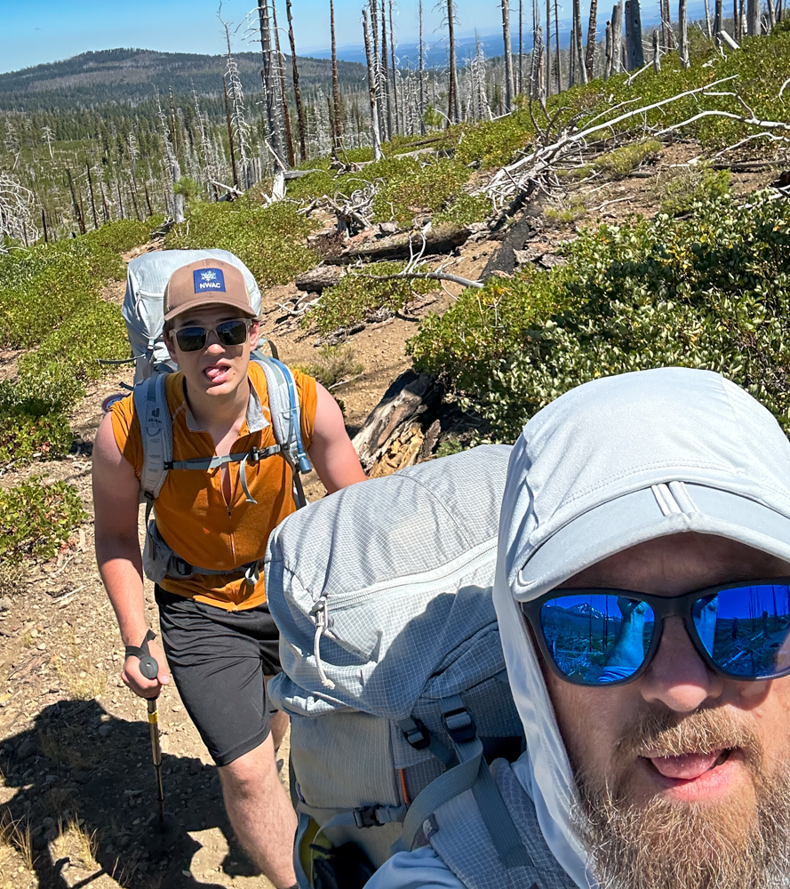
At the trailhead we were introduced to the heat. Brutal heat. And there's no shade. A fire had wiped out the forest in 2012. It was eerie walking through the recovering forest. Sure, there were plants growing amid the burned out trunks, but it was hardly the forest it was.
We set no speed records making our way up the mountain. When we crossed the first creek we dipped more than just our hats. It cooled us for a short while, but we were soon dry again. The first part of the route was relatively flat with rolling hills. As we got nearer to the peak it got steeper.
I had identified a spot that looked like it would be a good camp based on maps and satellite imagery. No chance. Instead we dropped our gear at the first spot that was remotely level and had running water. It also turned out to have a snow field providing deliciously cold air. And views of volcanos all around. It was perfect.
We woke early the next morning to get climbing before it got too hot. Not early enough, though. Thankfully, we were crossing a number of snow fields so we could fill our hats. The route wound up and over rock and snow. Off the snow, we could generally follow previous climbers. On the snow we made a beeline for the net waypoint.
This is probably a good time to demonstrate why my shoes don't last very long. I've been getting only 200-300 miles on a pair of shoes. Probably because I kick steps, climb rocks, and generally mistreat them. Hmph.
We gained the saddle between Middle and North Sister. The Collier Glacier separates the two peaks. It had refrozen overnight, but the sun was melting it quickly. Small rivulets flowed over the surface and made beautiful, bright blue pools. Looking up at North Sister, it was clear that wasn't on the itinerary for this trip. Middle, though...
We traversed along the edge of the glacier to get around Prouty Point. A narrow ridge runs between two more glaciers and provides a land bridge to the summit. Looking up at the summit it wasn't clear where we should go. The map didn't show even a climber's trail, but the ridge was clear.
In retrospect, we shouldn't have taken the direct approach. There were a few sketchy moments, but soon we were on the summit. Being on Middle Sister meant we were between North and South. Beyond South we could see Bachelor and Broken Top. And in almost every direction volcanos dotted the horizon. Some were familiar, some are future destinations.
While we didn't get the thick butterfly storm I'd seen before and had hoped for again, we had enough butterflies to make it interesting. In contrast. the route down, not direct, but switching back and forth across the steep slope, was a lot less sketchy than the climb up. in fact the whole hike back to camp was pretty mellow. We got back plenty early for dinner.
And glissading helped a lot.
Clouds rolled in over night. When I woke to look at the stars, half the sky was lit up while the other half was empty. In the morning, we packed up and made our way back through the burnt forest. The wind whistled through the trees adding an almost sinister character to the area. Between descending and it being 20 degrees cooler, it was a much more pleasant hike in spite of my mind reminding me this was the last backpacking trip I'd ever do with my kids.
Now I just need to con these young adults into going out with me.
📍 On the lands of the Cayuse, Umatilla and Walla Walla peoples.