How about we just cram it all into one day? (Yes. It says 25km.)
Let's review the Iceland checklist.
Volcano: check
Hot springs: check
Puffins: check
Black sand beaches: check
Reykjavik hot dogs: check
Waterfalls: check (and check)
Yarn stores: check
Scratch the horses: check
Separating continental plates: check
Craters: check
I think that's about everything... Oh wait. What about hiking? Is that something you can do in Iceland? Yeah. I guess you can. But why just go for a hike when you can go for an epic hike? So that's what we did.
The morning started early. Not so we could get on the trail at the break of dawn. No, that wasn't to be. We needed to get up so Henry and I could catch the bus. I hear you: Pfft. What kind of a trail starts at a bus stop? Except it wasn't a normal bus. This was a bus with six-wheel drive, big tires, and a driver with iron... lug nuts.
The bus was taking us to Ţórsmörk. (Remember: The saggy P is pronounced as TH so it's more like Thorsmork.) Why not just drive there ourselves? Because the Icelanders don't believe in bridges. Well, at least not for rivers that change coarse every season. Our wee little car would have been swept away. Heck, our bus was almost swept away! The driver assured us it had been worse last week so we had timed it well. (I'm glad we weren't there last week.)
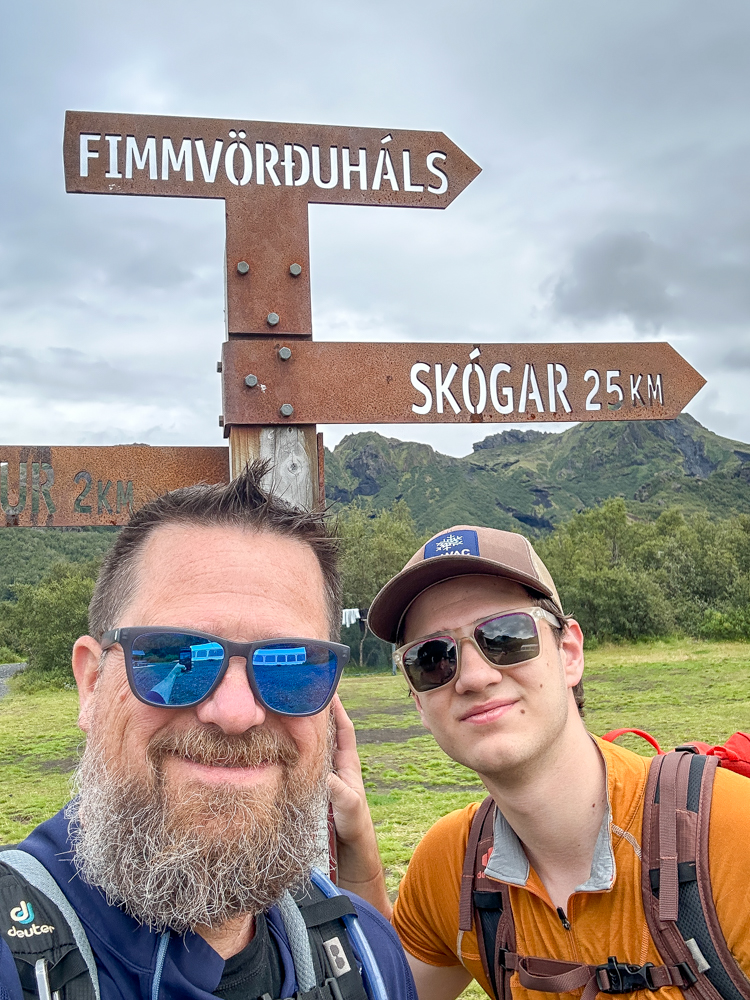
Virtually all the other riders got off at Ţórsmörk. The rest got off at Langidalur. That left just me and the boy riding to the Fimmvörđuháls trailhead. (No. I'm not even going to pretend to be able to pronounce that.) The sign did indicated we had 25km to go before we met up with the ladies at the Skógar waterfall. Onward.
We experienced three main sections of the trail. Sharp green, volcanic death zone, and mellow green.
Right off the bat the trail climbed steeply. We followed the ridgeline as it rose above the Strákagil Canyon. Since we were climbing while the river didn't we were soon way above it. We'd pause frequently and look around us completely amazed. And I mean completely amazed. Sharp cliffs, steep drops, and green everywhere. It was a combination of grass and moss. And of course, no trees.
As we climbed, the clouds rolled in. I'd been hoping we'd be able to have killer views for the entire day, but no. I downgraded my expectations to just being partially dry for the rest of the day.
From almost the trailhead, we could see where the trail climbed over a ridge far ahead. It never seemed to get closer. And there was no time we couldn't really see it. And then suddenly we were right under it. Strange how that happens.
Once we gained the ridge we found we were on a wide plateau. At least I think it was a wide plateau. We couldn't see more than a hundred meters. And no more green; just small rocks littering the dirt. We followed the trail and occasional markers into the void.
In fact, we followed too far and found ourselves looking down a cliff. A bit of backtracking and we descended a different cliff that was at least the route we were supposedly following. But what goes down obviously must go back up if you're not at the high point. So back up we went. And now that we were in the volcanic death zone (not the death zone) it was only appropriate we had to use ropes and chains as we climbed.
While the sharp green was gorgeous, this section was epic. There was almost no vegetation. Instead it was all loose rock and snow. As we climbed higher the clouds were rolling along the ground making for an otherworldly hike.
The rocks changed from brown to gray to lava red. We climbed to the top of Magni, one of the cinder cones created during the Eyjafjallajökull eruption in 2010. (You remember that one, right? It shut down European air traffic? Oh. Yeah. Now you remember.) It was surreal to stand on a mountain only 15 years old. (It would have been more surreal if we hadn't just touched rock that was only days old.)
Just around the corner we had to cross a plain of black pumice. By itself, it would have been impressive, but with the mist hanging just above the surface and slowly flowing along with us blew me away. Poor Henry had to hang out while I marveled at the sight.
Alas, we had to move on.
But we weren't done with the volcanic death zone. We had another three miles of pumice and snow and even an honest-to-goodness glacier. Unlike the types of adventures we have at home, it wasn't up, up, up. It was much more up, down, down, flat, up, down, up, up. Our mapping tools are usually wrong when calculating distance and gain, but it was completely befuddled by this terrain. So were some of the other hikers. It was clear they'd never really hike across snow or ice. They had traction, but we cruised right past them in our trail runners.
The upper parts of this section ran through the saddle between Eyjafjallajökull and Mýrdalsjökull. (No, I can't pronounce either of those. There are accent marks I didn't even know worked.) On either side we knew there were huge glaciers desperate to dazzle us, but the clouds kept a hold on the glaciated slopes.
The volcanic zone ended when we arrived at Baldvinsskáli. The roofline of the hut appeared from the mist. We'd heard it was one of those magical huts where you can buy food and drink. Nah. Not this one. There was space to cook, but nothing but candy bars and soft drinks to buy.
The final section of the route was the mellow green. Bear in mind, this section was by far the longest and although our maps calculate virtually no elevation gain, they lie. Up and down and crossing creeks and rivers. This was an "unmaintained" trail and was far more unmaintained than others. We had multiple spots where we stopped and looked around for the next marker. We saw only two others for the unmaintained section so we had the Skógá river all to ourselves.
Iceland is full of waterfalls. Drive for more than a few minutes and there's a waterfall. But this stretch was positively lousy with them. And they were all different types. Curtains and cascades and ones that spread out and then back together?
As we got closer to the end of the trail (or the beginning if you were starting at Skogafoss) we saw more and more people in fresher and fresher states. Many were carrying heavy loads that indicated they were likely camping somewhere on the mountain.
The final site on the trip was Skogafoss. It's so popular there are stairs and a viewing platform at the top. The crowds parted before our stink so we were able to look down to the parking lot where Amy and Clara were waiting.
Without a doubt, this was one of the most incredible hikes I've done. From the green of Ţórsmörk to the moonscape of the pass between the volcanos and back down to the green of the Skógá valley it was a constant feast for the eyes. If you have only one day to hike in Iceland and are up for 25km of trail, this is the hike.
And if you have three? Look north of Ţórsmörk in the Icelandic Highlands. There's a hut-to-hut trip there that will be on our itinerary when we go back.